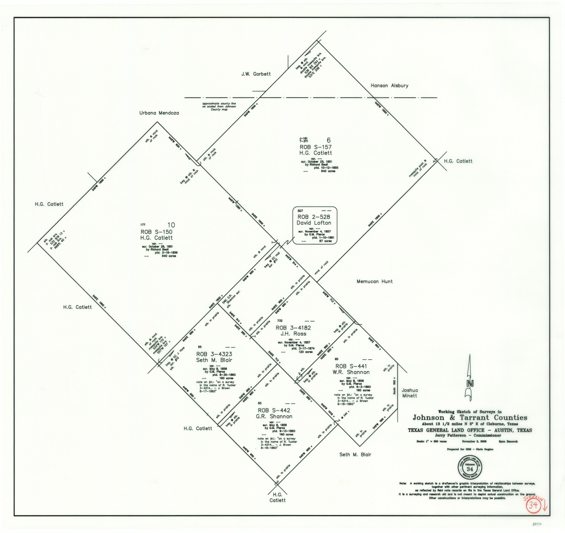
Johnson County Working Sketch 34
-
Map/Doc
88890
-
Collection
General Map Collection
-
Object Dates
11/6/2008 (Creation Date)
-
People and Organizations
Jerry E. Patterson (GLO Commissioner)
Ryan Hancock (Draftsman)
-
Counties
Johnson Tarrant
-
Subjects
Surveying Working Sketch
-
Height x Width
20.0 x 21.2 inches
50.8 x 53.9 cm
-
Scale
1" = 300 varas
Part of: General Map Collection
Shaw Farm, State Prison Farm, Bowie County

Print $20.00
- Digital $50.00
Shaw Farm, State Prison Farm, Bowie County
Size 16.1 x 17.9 inches
Map/Doc 73559
Val Verde County Sketch File B2

Print $20.00
- Digital $50.00
Val Verde County Sketch File B2
1910
Size 24.5 x 12.2 inches
Map/Doc 12544
Webb County Sketch File A

Print $20.00
- Digital $50.00
Webb County Sketch File A
1891
Size 35.3 x 17.1 inches
Map/Doc 12603
Robertson County Rolled Sketch 6

Print $20.00
- Digital $50.00
Robertson County Rolled Sketch 6
Size 22.8 x 15.6 inches
Map/Doc 7512
Wise County Sketch File 2a

Print $4.00
- Digital $50.00
Wise County Sketch File 2a
1856
Size 12.3 x 8.1 inches
Map/Doc 40526
Old Miscellaneous File 28

Print $6.00
- Digital $50.00
Old Miscellaneous File 28
1838
Size 10.2 x 8.4 inches
Map/Doc 75736
Tom Green Co.

Print $40.00
- Digital $50.00
Tom Green Co.
1887
Size 43.9 x 111.7 inches
Map/Doc 82063
Stephens County Sketch File 12a

Print $23.00
- Digital $50.00
Stephens County Sketch File 12a
Size 18.2 x 11.2 inches
Map/Doc 37061
Menard County Boundary File 3

Print $4.00
- Digital $50.00
Menard County Boundary File 3
Size 10.6 x 8.0 inches
Map/Doc 57072
Armstrong County Working Sketch 6

Print $20.00
- Digital $50.00
Armstrong County Working Sketch 6
1929
Size 24.3 x 19.4 inches
Map/Doc 67237
Culberson County Working Sketch 21

Print $40.00
- Digital $50.00
Culberson County Working Sketch 21
1936
Size 36.7 x 57.8 inches
Map/Doc 68473
Flight Mission No. DQO-7K, Frame 99, Galveston County

Print $20.00
- Digital $50.00
Flight Mission No. DQO-7K, Frame 99, Galveston County
1952
Size 18.7 x 22.5 inches
Map/Doc 85114
You may also like
San Augustine County Sketch File 9

Print $4.00
San Augustine County Sketch File 9
1860
Size 12.6 x 7.6 inches
Map/Doc 35650
[Plat of Victoria, Texas]
![76270, [Plat of Victoria, Texas], Texas State Library and Archives](https://historictexasmaps.com/wmedia_w700/maps/76270.tif.jpg)
Print $20.00
[Plat of Victoria, Texas]
1850
Size 14.1 x 11.5 inches
Map/Doc 76270
Jules A. Appler's Map of San Antonio, Texas and Suburbs

Print $20.00
Jules A. Appler's Map of San Antonio, Texas and Suburbs
1900
Size 43.0 x 29.7 inches
Map/Doc 79303
Carson County Boundary File 3

Print $2.00
- Digital $50.00
Carson County Boundary File 3
Size 13.3 x 8.3 inches
Map/Doc 51131
Flight Mission No. CRC-4R, Frame 172, Chambers County

Print $20.00
- Digital $50.00
Flight Mission No. CRC-4R, Frame 172, Chambers County
1956
Size 18.6 x 22.3 inches
Map/Doc 84923
Midland County Working Sketch 15

Print $20.00
- Digital $50.00
Midland County Working Sketch 15
1953
Size 27.2 x 28.6 inches
Map/Doc 70995
Points of Interest & Road Map of Scenicland, U.S.A. and United States [Recto]
![94192, Points of Interest & Road Map of Scenicland, U.S.A. and United States [Recto], General Map Collection](https://historictexasmaps.com/wmedia_w700/maps/94192.tif.jpg)
Points of Interest & Road Map of Scenicland, U.S.A. and United States [Recto]
1966
Size 34.7 x 22.4 inches
Map/Doc 94192
Van Zandt County Working Sketch 9

Print $20.00
- Digital $50.00
Van Zandt County Working Sketch 9
1982
Size 12.6 x 11.7 inches
Map/Doc 72259
Comanche County Working Sketch 13

Print $20.00
- Digital $50.00
Comanche County Working Sketch 13
1957
Size 18.4 x 15.0 inches
Map/Doc 68147
General Highway Map, DeWitt County, Texas

Print $20.00
General Highway Map, DeWitt County, Texas
1961
Size 18.3 x 24.5 inches
Map/Doc 79442
Jones County Sketch File 6

Print $2.00
- Digital $50.00
Jones County Sketch File 6
1873
Size 8.3 x 11.8 inches
Map/Doc 28494
Jasper County Boundary File 4a

Print $20.00
- Digital $50.00
Jasper County Boundary File 4a
Size 36.6 x 17.6 inches
Map/Doc 55491