Old Miscellaneous File 28
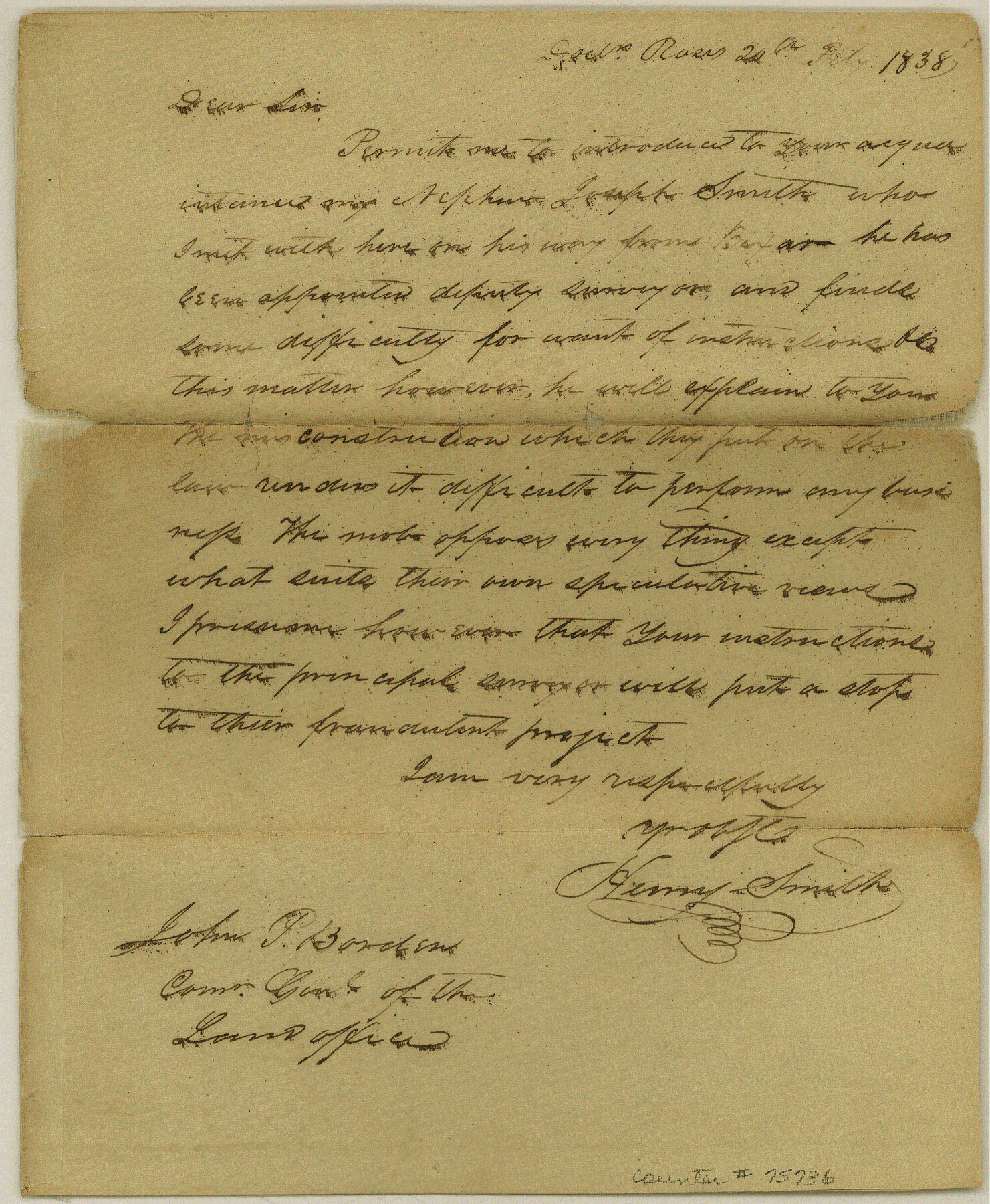
Letter regarding Deputy Surveyor
-
Map/Doc
75736
-
Collection
General Map Collection
-
Object Dates
1838/2/20 (Creation Date)
1985/2/8 (File Date)
-
People and Organizations
Henry Smith (Author)
-
Subjects
Legal
-
Height x Width
10.2 x 8.4 inches
25.9 x 21.3 cm
Part of: General Map Collection
Hopkins County Sketch File 2

Print $28.00
- Digital $50.00
Hopkins County Sketch File 2
1845
Size 11.1 x 7.9 inches
Map/Doc 26678
Flight Mission No. BRE-1P, Frame 147, Nueces County

Print $20.00
- Digital $50.00
Flight Mission No. BRE-1P, Frame 147, Nueces County
1956
Size 18.5 x 22.3 inches
Map/Doc 86707
Sherman County

Print $20.00
- Digital $50.00
Sherman County
1932
Size 39.8 x 37.3 inches
Map/Doc 95640
Presidio County Working Sketch 121b

Print $20.00
- Digital $50.00
Presidio County Working Sketch 121b
1984
Size 36.0 x 41.5 inches
Map/Doc 71799
Fort Bend County Sketch File 33

Print $20.00
- Digital $50.00
Fort Bend County Sketch File 33
1889
Size 23.6 x 24.5 inches
Map/Doc 11513
Robertson County Sketch File 2

Print $16.00
Robertson County Sketch File 2
1858
Size 10.1 x 8.2 inches
Map/Doc 35343
Lee County Working Sketch 12

Print $20.00
- Digital $50.00
Lee County Working Sketch 12
1980
Size 12.3 x 16.3 inches
Map/Doc 70391
Cass County Working Sketch 24

Print $20.00
- Digital $50.00
Cass County Working Sketch 24
1973
Size 35.6 x 27.7 inches
Map/Doc 67927
Blanco County Sketch File 18

Print $4.00
- Digital $50.00
Blanco County Sketch File 18
1877
Size 12.6 x 8.5 inches
Map/Doc 14594
Bandera County Working Sketch 35

Print $20.00
- Digital $50.00
Bandera County Working Sketch 35
1965
Size 20.8 x 21.6 inches
Map/Doc 67631
Coke County Boundary File 1

Print $50.00
- Digital $50.00
Coke County Boundary File 1
Size 8.9 x 4.0 inches
Map/Doc 51570
FT. W. & R. G. Ry. Right of Way Map, Whiteland to Lightner, Concho County, Texas

Print $40.00
- Digital $50.00
FT. W. & R. G. Ry. Right of Way Map, Whiteland to Lightner, Concho County, Texas
1918
Size 37.5 x 68.4 inches
Map/Doc 61413
You may also like
[Blocks 10T, O7, S2, S3, T2, T3, JB and A]
![89953, [Blocks 10T, O7, S2, S3, T2, T3, JB and A], Twichell Survey Records](https://historictexasmaps.com/wmedia_w700/maps/89953-1.tif.jpg)
Print $20.00
- Digital $50.00
[Blocks 10T, O7, S2, S3, T2, T3, JB and A]
Size 41.8 x 37.7 inches
Map/Doc 89953
Flight Mission No. DCL-7C, Frame 116, Kenedy County

Print $20.00
- Digital $50.00
Flight Mission No. DCL-7C, Frame 116, Kenedy County
1943
Size 18.6 x 22.4 inches
Map/Doc 86081
From Citizens of Austin County Requesting to be Attached to Washington County, January 4, 1842

Print $20.00
From Citizens of Austin County Requesting to be Attached to Washington County, January 4, 1842
2020
Size 20.2 x 21.7 inches
Map/Doc 96396
Santa Fe Lines - Texas, Oklahoma, and Louisiana

Print $20.00
- Digital $50.00
Santa Fe Lines - Texas, Oklahoma, and Louisiana
1923
Size 9.3 x 8.3 inches
Map/Doc 96595
[Sketch for Mineral Application 12206 - Cow Bayou, O. B. Sawyer]
![65569, [Sketch for Mineral Application 12206 - Cow Bayou, O. B. Sawyer], General Map Collection](https://historictexasmaps.com/wmedia_w700/maps/65569.tif.jpg)
Print $40.00
- Digital $50.00
[Sketch for Mineral Application 12206 - Cow Bayou, O. B. Sawyer]
Size 63.3 x 36.5 inches
Map/Doc 65569
Graham's Addition Being a Subdivision of a Portion of Lot No. 1 of Spear League

Print $20.00
- Digital $50.00
Graham's Addition Being a Subdivision of a Portion of Lot No. 1 of Spear League
1914
Size 13.6 x 33.0 inches
Map/Doc 542
Briscoe County Rolled Sketch 14A

Print $40.00
- Digital $50.00
Briscoe County Rolled Sketch 14A
1913
Size 34.6 x 48.1 inches
Map/Doc 8530
Childress County Rolled Sketch 19

Print $20.00
- Digital $50.00
Childress County Rolled Sketch 19
2004
Size 24.6 x 18.6 inches
Map/Doc 81937
Map of Erath County

Print $20.00
- Digital $50.00
Map of Erath County
1872
Size 21.0 x 19.4 inches
Map/Doc 4537
[Anderson County]
![5051, [Anderson County], General Map Collection](https://historictexasmaps.com/wmedia_w700/maps/5051-GC.tif.jpg)
Print $20.00
- Digital $50.00
[Anderson County]
1848
Size 26.0 x 19.9 inches
Map/Doc 5051
General Highway Map. Detail of Cities and Towns in Waller County, Texas [Hempstead and vicinity]
![79701, General Highway Map. Detail of Cities and Towns in Waller County, Texas [Hempstead and vicinity], Texas State Library and Archives](https://historictexasmaps.com/wmedia_w700/maps/79701.tif.jpg)
Print $20.00
General Highway Map. Detail of Cities and Towns in Waller County, Texas [Hempstead and vicinity]
1961
Size 24.8 x 18.2 inches
Map/Doc 79701
Genl. Austins Map of Texas With Parts of the Adjoining States

Print $20.00
- Digital $50.00
Genl. Austins Map of Texas With Parts of the Adjoining States
1840
Size 28.5 x 23.4 inches
Map/Doc 2116