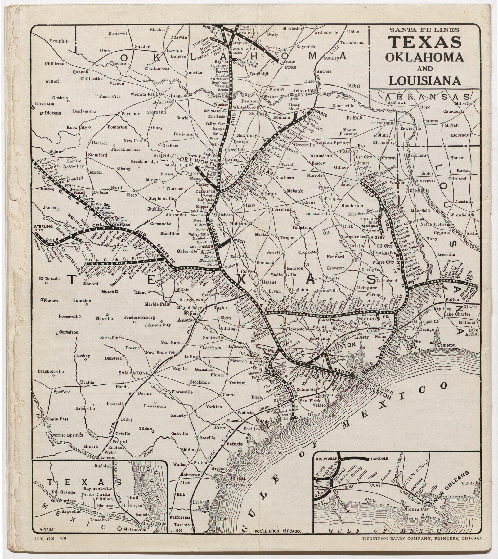
Santa Fe Lines - Texas, Oklahoma, and Louisiana
-
Map/Doc
96595
-
Collection
Cobb Digital Map Collection
-
Object Dates
7/1926 (Edition Date)
8/6/1923 (Creation Date)
-
People and Organizations
Poole Bros. (Publisher)
Hedstrom-Barry Company (Printer)
-
Subjects
Railroads State of Texas
-
Height x Width
9.3 x 8.3 inches
23.6 x 21.1 cm
-
Medium
digital image
-
Comments
Courtesy of John & Diana Cobb.
To view the booklet, "Texas along the G. C. & S. F. Ry.", in which this map was contained, click the "Download PDF" link above.
Part of: Cobb Digital Map Collection

Map showing those portions of Texas traversed by the Rock Island System and connecting lines

Print $20.00
- Digital $50.00
Map showing those portions of Texas traversed by the Rock Island System and connecting lines
1903
Size 16.4 x 24.0 inches
Map/Doc 96587
Houston - Where Seventeen Railroads Meet the Sea

Houston - Where Seventeen Railroads Meet the Sea
1913
Size 6.1 x 8.2 inches
Map/Doc 97069
State of Texas showing the Lower Rio Grande Valley

Print $20.00
- Digital $50.00
State of Texas showing the Lower Rio Grande Valley
1920
Size 14.0 x 13.4 inches
Map/Doc 95802
Map showing the route of the Corpus Christi, San Diego & Rio Grande Railroad, and its connections

Print $20.00
- Digital $50.00
Map showing the route of the Corpus Christi, San Diego & Rio Grande Railroad, and its connections
1880
Size 11.9 x 9.1 inches
Map/Doc 96765
Map of the Texas & Pacific Railway "Gould System" Lines and connections

Print $20.00
- Digital $50.00
Map of the Texas & Pacific Railway "Gould System" Lines and connections
1906
Size 17.7 x 36.6 inches
Map/Doc 95769

Three Through Trains for Texas Travelers via Katy Line - Missouri, Kansas and Texas Railway from Chicago, St. Louis, Kansas City and a comprehensive local service reaching all points in Missouri, Kansas, Texas and Indian Territory

Three Through Trains for Texas Travelers via Katy Line - Missouri, Kansas and Texas Railway from Chicago, St. Louis, Kansas City and a comprehensive local service reaching all points in Missouri, Kansas, Texas and Indian Territory
Size 9.5 x 6.3 inches
Map/Doc 96605
Sectional map of Central and Eastern Texas traversed by the Missouri, Kansas & Texas Railway, showing the crops adapted to each section, with the elevation and average annual rainfall

Print $20.00
- Digital $50.00
Sectional map of Central and Eastern Texas traversed by the Missouri, Kansas & Texas Railway, showing the crops adapted to each section, with the elevation and average annual rainfall
1902
Size 19.7 x 16.2 inches
Map/Doc 95812

Map of the Texas & Pacific Railway and connections

Print $20.00
- Digital $50.00
Map of the Texas & Pacific Railway and connections
1899
Size 17.9 x 36.6 inches
Map/Doc 95765
Map of the Texas & Pacific Railway and connections

Print $20.00
- Digital $50.00
Map of the Texas & Pacific Railway and connections
1898
Size 17.8 x 36.4 inches
Map/Doc 95764
You may also like

Delta County Sketch File 3

Print $6.00
- Digital $50.00
Delta County Sketch File 3
Size 10.2 x 12.6 inches
Map/Doc 20672
Parker County Sketch File 49

Print $6.00
- Digital $50.00
Parker County Sketch File 49
Size 10.6 x 8.8 inches
Map/Doc 33618
Hays County Rolled Sketch 31

Print $20.00
- Digital $50.00
Hays County Rolled Sketch 31
2001
Size 24.0 x 34.7 inches
Map/Doc 76421
Brewster County Rolled Sketch 114

Print $20.00
- Digital $50.00
Brewster County Rolled Sketch 114
1964
Size 11.6 x 17.3 inches
Map/Doc 5273
Map of the Military Department of the Gulf

Print $20.00
Map of the Military Department of the Gulf
1864
Size 24.4 x 45.7 inches
Map/Doc 93568
Dallas County Boundary File 5

Print $120.00
- Digital $50.00
Dallas County Boundary File 5
Size 11.5 x 72.2 inches
Map/Doc 52160
[Stone, Kyle and Kyle Block M6]
![90414, [Stone, Kyle and Kyle Block M6], Twichell Survey Records](https://historictexasmaps.com/wmedia_w700/maps/90414-1.tif.jpg)
Print $20.00
- Digital $50.00
[Stone, Kyle and Kyle Block M6]
1908
Size 18.6 x 25.5 inches
Map/Doc 90414
La Salle County Working Sketch 14

Print $20.00
- Digital $50.00
La Salle County Working Sketch 14
1941
Size 37.8 x 36.7 inches
Map/Doc 70315
Collingsworth County Working Sketch 2

Print $20.00
- Digital $50.00
Collingsworth County Working Sketch 2
1957
Size 10.2 x 32.6 inches
Map/Doc 63762
Henderson County Working Sketch 24

Print $20.00
- Digital $50.00
Henderson County Working Sketch 24
1952
Size 29.3 x 22.9 inches
Map/Doc 66157
Upton County Rolled Sketch 4

Print $20.00
- Digital $50.00
Upton County Rolled Sketch 4
Size 34.4 x 42.8 inches
Map/Doc 76025