Railroad and County Map of Texas

Print $20.00
- Digital $50.00
Railroad and County Map of Texas
1906
Size: 46.0 x 47.6 inches
10748
National Map Company's Map of Texas showing counties, cities, towns, villages and post offices, steam and electric railways with stations and distance between stations

Print $40.00
- Digital $50.00
National Map Company's Map of Texas showing counties, cities, towns, villages and post offices, steam and electric railways with stations and distance between stations
1920
Size: 50.3 x 51.1 inches
10749
National Map Company's Map of Texas showing counties, cities, towns, villages and post offices, steam and electric railways with stations and distance between stations

Print $40.00
- Digital $50.00
National Map Company's Map of Texas showing counties, cities, towns, villages and post offices, steam and electric railways with stations and distance between stations
1920
Size: 49.1 x 50.3 inches
10750
Natural Heritage of Texas

Print $40.00
- Digital $50.00
Natural Heritage of Texas
1986
Size: 54.3 x 56.0 inches
10786
Map of the State of Texas

Print $40.00
- Digital $50.00
Map of the State of Texas
1879
Size: 102.7 x 106.6 inches
16973
Map of the State of Texas

Print $40.00
- Digital $50.00
Map of the State of Texas
1879
Size: 102.3 x 106.1 inches
16974
Map of the State of Texas Showing Original Land Districts

Print $20.00
- Digital $50.00
Map of the State of Texas Showing Original Land Districts
1891
Size: 45.6 x 43.0 inches
1995
Post Route Map of the State of Texas showing post offices with the intermediate distances on mail routes in operation on the 1st of March, 1907

Print $40.00
- Digital $50.00
Post Route Map of the State of Texas showing post offices with the intermediate distances on mail routes in operation on the 1st of March, 1907
1907
Size: 50.1 x 68.0 inches
2090
Texas Railroad Map

Print $20.00
- Digital $50.00
Texas Railroad Map
1981
Size: 34.8 x 35.6 inches
2101
Carte du Texas par M. Maris

Print $20.00
- Digital $50.00
Carte du Texas par M. Maris
1846
Size: 19.3 x 17.2 inches
2119
Hoffman & Walker's Pictorial, Historical Map of Texas

Hoffman & Walker's Pictorial, Historical Map of Texas
1960
Size: 44.0 x 45.5 inches
2122
Karte des Staates, Texas

Print $20.00
- Digital $50.00
Karte des Staates, Texas
1851
Size: 25.5 x 30.8 inches
2123
Texas map showing principal forts

Print $20.00
- Digital $50.00
Texas map showing principal forts
1852
Size: 34.7 x 25.1 inches
2125
J. De Cordova's Map of the State of Texas Compiled from the records of the General Land Office of the State

Print $20.00
- Digital $50.00
J. De Cordova's Map of the State of Texas Compiled from the records of the General Land Office of the State
1858
Size: 31.6 x 29.6 inches
2127
Traveller's Map of the State of Texas

Print $20.00
- Digital $50.00
Traveller's Map of the State of Texas
1867
Size: 40.7 x 38.7 inches
2130
Map of the State of Texas

Print $40.00
- Digital $50.00
Map of the State of Texas
1879
Size: 47.1 x 51.4 inches
2133
Official Map of the State of Texas to accompany the Statistical and Descriptive Work, "Resources, Soil and Climate of Texas"

Print $20.00
- Digital $50.00
Official Map of the State of Texas to accompany the Statistical and Descriptive Work, "Resources, Soil and Climate of Texas"
1882
Size: 31.1 x 33.1 inches
2134
Rand, McNally and Co.'s New Enlarged Scale Railroad and County Map of Texas, Showing Every Railroad Station and Post Office in the State

Print $20.00
- Digital $50.00
Rand, McNally and Co.'s New Enlarged Scale Railroad and County Map of Texas, Showing Every Railroad Station and Post Office in the State
1882
Size: 23.7 x 29.8 inches
2135
Map of the State of Texas Showing Original Land Districts

Print $20.00
- Digital $50.00
Map of the State of Texas Showing Original Land Districts
1891
Size: 42.2 x 42.4 inches
2138
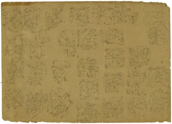
[Drawings of individual counties for Pressler and Langermann's 1879 Map of Texas]
Print $20.00
- Digital $50.00
[Drawings of individual counties for Pressler and Langermann's 1879 Map of Texas]
1878
Size: 28.5 x 42.0 inches
2140
Railroad and County Map of Texas

Print $20.00
- Digital $50.00
Railroad and County Map of Texas
1908
Size: 42.7 x 44.7 inches
2141
Correct Map of Texas and Louisiana

Print $40.00
- Digital $50.00
Correct Map of Texas and Louisiana
1917
Size: 41.6 x 53.6 inches
2142
Fifteenth Census 1930 Population - Texas

Print $20.00
- Digital $50.00
Fifteenth Census 1930 Population - Texas
1930
Size: 19.5 x 22.6 inches
2146
Rand McNally Standard Map of Texas

Rand McNally Standard Map of Texas
1930
Size: 34.6 x 28.0 inches
2147
Map of Defunct and Ghost Counties in Texas

Print $20.00
- Digital $50.00
Map of Defunct and Ghost Counties in Texas
1939
Size: 35.0 x 35.9 inches
2148
Railroad and County Map of Texas
Print $20.00
- Digital $50.00
Railroad and County Map of Texas
1906
-
Size
46.0 x 47.6 inches
-
Map/Doc
10748
-
Creation Date
1906
National Map Company's Map of Texas showing counties, cities, towns, villages and post offices, steam and electric railways with stations and distance between stations
Print $40.00
- Digital $50.00
National Map Company's Map of Texas showing counties, cities, towns, villages and post offices, steam and electric railways with stations and distance between stations
1920
-
Size
50.3 x 51.1 inches
-
Map/Doc
10749
-
Creation Date
1920
National Map Company's Map of Texas showing counties, cities, towns, villages and post offices, steam and electric railways with stations and distance between stations
Print $40.00
- Digital $50.00
National Map Company's Map of Texas showing counties, cities, towns, villages and post offices, steam and electric railways with stations and distance between stations
1920
-
Size
49.1 x 50.3 inches
-
Map/Doc
10750
-
Creation Date
1920
Natural Heritage of Texas
Print $40.00
- Digital $50.00
Natural Heritage of Texas
1986
-
Size
54.3 x 56.0 inches
-
Map/Doc
10786
-
Creation Date
1986
Map of the State of Texas
Print $40.00
- Digital $50.00
Map of the State of Texas
1879
-
Size
102.7 x 106.6 inches
-
Map/Doc
16973
-
Creation Date
1879
Map of the State of Texas
Print $40.00
- Digital $50.00
Map of the State of Texas
1879
Compiled from the records on file in the General Land Office of the State, the U.S. coast surveys,...
-
Size
102.3 x 106.1 inches
-
Map/Doc
16974
-
Creation Date
1879
Map of the State of Texas Showing Original Land Districts
Print $20.00
- Digital $50.00
Map of the State of Texas Showing Original Land Districts
1891
-
Size
45.6 x 43.0 inches
-
Map/Doc
1995
-
Creation Date
1891
Post Route Map of the State of Texas showing post offices with the intermediate distances on mail routes in operation on the 1st of March, 1907
Print $40.00
- Digital $50.00
Post Route Map of the State of Texas showing post offices with the intermediate distances on mail routes in operation on the 1st of March, 1907
1907
-
Size
50.1 x 68.0 inches
-
Map/Doc
2090
-
Creation Date
1907
State of Texas

Print $40.00
- Digital $50.00
State of Texas
1965
-
Size
42.8 x 52.5 inches
-
Map/Doc
2095
-
Creation Date
1965
Texas Railroad Map
Print $20.00
- Digital $50.00
Texas Railroad Map
1981
-
Size
34.8 x 35.6 inches
-
Map/Doc
2101
-
Creation Date
1981
Carte du Texas par M. Maris
Print $20.00
- Digital $50.00
Carte du Texas par M. Maris
1846
-
Size
19.3 x 17.2 inches
-
Map/Doc
2119
-
Creation Date
1846
Hoffman & Walker's Pictorial, Historical Map of Texas
Hoffman & Walker's Pictorial, Historical Map of Texas
1960
-
Size
44.0 x 45.5 inches
-
Map/Doc
2122
-
Creation Date
1960
Karte des Staates, Texas
Print $20.00
- Digital $50.00
Karte des Staates, Texas
1851
-
Size
25.5 x 30.8 inches
-
Map/Doc
2123
-
Creation Date
1851
Texas map showing principal forts
Print $20.00
- Digital $50.00
Texas map showing principal forts
1852
-
Size
34.7 x 25.1 inches
-
Map/Doc
2125
-
Creation Date
1852
J. De Cordova's Map of the State of Texas Compiled from the records of the General Land Office of the State
Print $20.00
- Digital $50.00
J. De Cordova's Map of the State of Texas Compiled from the records of the General Land Office of the State
1858
-
Size
31.6 x 29.6 inches
-
Map/Doc
2127
-
Creation Date
1858
Traveller's Map of the State of Texas
Print $20.00
- Digital $50.00
Traveller's Map of the State of Texas
1867
-
Size
40.7 x 38.7 inches
-
Map/Doc
2130
-
Creation Date
1867
Map of the State of Texas
Print $40.00
- Digital $50.00
Map of the State of Texas
1879
-
Size
47.1 x 51.4 inches
-
Map/Doc
2133
-
Creation Date
1879
Official Map of the State of Texas to accompany the Statistical and Descriptive Work, "Resources, Soil and Climate of Texas"
Print $20.00
- Digital $50.00
Official Map of the State of Texas to accompany the Statistical and Descriptive Work, "Resources, Soil and Climate of Texas"
1882
-
Size
31.1 x 33.1 inches
-
Map/Doc
2134
-
Creation Date
1882
Rand, McNally and Co.'s New Enlarged Scale Railroad and County Map of Texas, Showing Every Railroad Station and Post Office in the State
Print $20.00
- Digital $50.00
Rand, McNally and Co.'s New Enlarged Scale Railroad and County Map of Texas, Showing Every Railroad Station and Post Office in the State
1882
-
Size
23.7 x 29.8 inches
-
Map/Doc
2135
-
Creation Date
1882
Map of the State of Texas Showing Original Land Districts
Print $20.00
- Digital $50.00
Map of the State of Texas Showing Original Land Districts
1891
-
Size
42.2 x 42.4 inches
-
Map/Doc
2138
-
Creation Date
1891
[Drawings of individual counties for Pressler and Langermann's 1879 Map of Texas]
Print $20.00
- Digital $50.00
[Drawings of individual counties for Pressler and Langermann's 1879 Map of Texas]
1878
-
Size
28.5 x 42.0 inches
-
Map/Doc
2140
-
Creation Date
1878
Railroad and County Map of Texas
Print $20.00
- Digital $50.00
Railroad and County Map of Texas
1908
-
Size
42.7 x 44.7 inches
-
Map/Doc
2141
-
Creation Date
1908
Correct Map of Texas and Louisiana
Print $40.00
- Digital $50.00
Correct Map of Texas and Louisiana
1917
-
Size
41.6 x 53.6 inches
-
Map/Doc
2142
-
Creation Date
1917
Fifteenth Census 1930 Population - Texas
Print $20.00
- Digital $50.00
Fifteenth Census 1930 Population - Texas
1930
-
Size
19.5 x 22.6 inches
-
Map/Doc
2146
-
Creation Date
1930
Rand McNally Standard Map of Texas
Rand McNally Standard Map of Texas
1930
-
Size
34.6 x 28.0 inches
-
Map/Doc
2147
-
Creation Date
1930
Map of Defunct and Ghost Counties in Texas
Print $20.00
- Digital $50.00
Map of Defunct and Ghost Counties in Texas
1939
-
Size
35.0 x 35.9 inches
-
Map/Doc
2148
-
Creation Date
1939
Texas

Print $20.00
- Digital $50.00
Texas
1954
-
Size
33.8 x 35.4 inches
-
Map/Doc
2149
-
Creation Date
1954
Texas

Print $20.00
- Digital $50.00
Texas
1959
-
Size
32.8 x 34.5 inches
-
Map/Doc
2151
-
Creation Date
1959
Texas

Print $20.00
- Digital $50.00
Texas
1959
-
Size
33.4 x 34.6 inches
-
Map/Doc
2152
-
Creation Date
1959
Texas

Print $20.00
- Digital $50.00
Texas
1971
-
Size
32.6 x 36.8 inches
-
Map/Doc
2153
-
Creation Date
1971