"Iron Mountain Route" to all parts of Texas - I. & G. N., T. & P., Iron Mountain - "The Way to Texas"

Print $20.00
- Digital $50.00
"Iron Mountain Route" to all parts of Texas - I. & G. N., T. & P., Iron Mountain - "The Way to Texas"
1909
Size: 22.0 x 24.0 inches
95792
"Iron Mountain Route" to all parts of Texas - I. & G. N., T. & P., Iron Mountain - "The Way to Texas"

Print $20.00
- Digital $50.00
"Iron Mountain Route" to all parts of Texas - I. & G. N., T. & P., Iron Mountain - "The Way to Texas"
1909
Size: 21.8 x 24.0 inches
95793
"Texas New Yorker's" Railroad Map of Texas

Print $20.00
"Texas New Yorker's" Railroad Map of Texas
1874
Size: 22.8 x 32.3 inches
76210
1960 Texas Official Highway Travel Map

Digital $50.00
1960 Texas Official Highway Travel Map
Size: 28.4 x 36.2 inches
94329
1960 Texas Official Highway Travel Map

Digital $50.00
1960 Texas Official Highway Travel Map
Size: 28.3 x 36.5 inches
94330


1968 Texas Official State Highway Map

Digital $50.00
1968 Texas Official State Highway Map
Size: 28.2 x 36.3 inches
94320

2008 Official Travel Map Texas

Digital $50.00
2008 Official Travel Map Texas
Size: 33.4 x 36.5 inches
94310
A Geographically Correct Map of the State of Texas

Print $20.00
- Digital $50.00
A Geographically Correct Map of the State of Texas
1876
Size: 20.0 x 21.5 inches
93397
A Geographically Correct Map of the State of Texas

Print $20.00
- Digital $50.00
A Geographically Correct Map of the State of Texas
1876
Size: 20.4 x 21.7 inches
95361
A Geographically Correct Map of the State of Texas

Print $20.00
- Digital $50.00
A Geographically Correct Map of the State of Texas
1876
Size: 20.4 x 21.9 inches
95362
A Geographically Correct Map of the State of Texas

Print $20.00
- Digital $50.00
A Geographically Correct Map of the State of Texas
1878
Size: 19.5 x 21.0 inches
95757
A Geographically Correct Map of the State of Texas

Print $20.00
- Digital $50.00
A Geographically Correct Map of the State of Texas
1876
Size: 19.6 x 21.4 inches
96508
A Map of Texas Showing the State Parks and the Municipal Parks

Print $20.00
A Map of Texas Showing the State Parks and the Municipal Parks
1936
Size: 34.8 x 37.5 inches
76311
A Map of Texas published by the Dallas Morning News for the Texas Almanac and State Industrial Guide

A Map of Texas published by the Dallas Morning News for the Texas Almanac and State Industrial Guide
1936
Size: 20.3 x 26.1 inches
94293
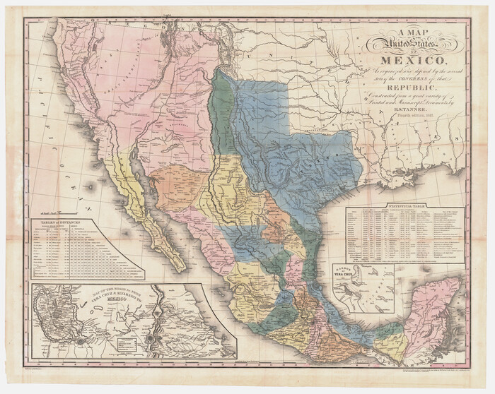
A Map of the United States of Mexico as organized and defined by the several Acts of the Congress of that Republic
Print $20.00
- Digital $50.00
A Map of the United States of Mexico as organized and defined by the several Acts of the Congress of that Republic
1847
Size: 25.3 x 31.8 inches
95913
A New and Correct County Map of the State of Texas

Print $20.00
- Digital $50.00
A New and Correct County Map of the State of Texas
1891
Size: 22.4 x 27.3 inches
95760
A new map of the states of Texas & California, the territories of Oregon, New Mexico, Utah, and the regions adjacent: compiled from the most recent authorities

Print $20.00
- Digital $50.00
A new map of the states of Texas & California, the territories of Oregon, New Mexico, Utah, and the regions adjacent: compiled from the most recent authorities
1851
Size: 22.4 x 20.4 inches
94051
A. R. Roessler's Latest Map of the State of Texas Exhibiting Mineral and Agricultural Districts, Post Offices and Mailroutes, Railroads projected and finished, Timber, Prairie, Swamp Lands, etc. etc. etc.

Print $20.00
- Digital $50.00
A. R. Roessler's Latest Map of the State of Texas Exhibiting Mineral and Agricultural Districts, Post Offices and Mailroutes, Railroads projected and finished, Timber, Prairie, Swamp Lands, etc. etc. etc.
1874
Size: 40.8 x 47.4 inches
93934
A.R. Roessler's Latest Map of the State of Texas Exhibiting Mineral and Agricultural Districts, Post Offices & Mailroutes, Railroads projected and finished, Timber, Prairie, Swamp Lands, etc. etc. etc.

Print $20.00
- Digital $50.00
A.R. Roessler's Latest Map of the State of Texas Exhibiting Mineral and Agricultural Districts, Post Offices & Mailroutes, Railroads projected and finished, Timber, Prairie, Swamp Lands, etc. etc. etc.
1874
Size: 39.9 x 44.6 inches
95369
A.R. Roessler's Latest Map of the State of Texas Exhibiting Mineral and Agricultural Districts, Post Offices and Mailroutes, Railroads projected and finished, Timber, Prairie, Swamp Lands, etc. etc. etc.

Print $20.00
A.R. Roessler's Latest Map of the State of Texas Exhibiting Mineral and Agricultural Districts, Post Offices and Mailroutes, Railroads projected and finished, Timber, Prairie, Swamp Lands, etc. etc. etc.
1874
Size: 39.7 x 46.8 inches
76254
Acreage in Texas by Counties

Print $20.00
- Digital $50.00
Acreage in Texas by Counties
Size: 19.3 x 20.0 inches
62974
America's Fun-Tier: Texas 1965 Official Highway Travel Map

Digital $50.00
America's Fun-Tier: Texas 1965 Official Highway Travel Map
Size: 28.2 x 36.4 inches
94325
"Iron Mountain Route" to all parts of Texas - I. & G. N., T. & P., Iron Mountain - "The Way to Texas"
Print $20.00
- Digital $50.00
"Iron Mountain Route" to all parts of Texas - I. & G. N., T. & P., Iron Mountain - "The Way to Texas"
1909
-
Size
22.0 x 24.0 inches
-
Map/Doc
95792
-
Creation Date
1909
"Iron Mountain Route" to all parts of Texas - I. & G. N., T. & P., Iron Mountain - "The Way to Texas"
Print $20.00
- Digital $50.00
"Iron Mountain Route" to all parts of Texas - I. & G. N., T. & P., Iron Mountain - "The Way to Texas"
1909
-
Size
21.8 x 24.0 inches
-
Map/Doc
95793
-
Creation Date
1909
"Texas New Yorker's" Railroad Map of Texas
Print $20.00
"Texas New Yorker's" Railroad Map of Texas
1874
-
Size
22.8 x 32.3 inches
-
Map/Doc
76210
-
Creation Date
1874
1960 Texas Official Highway Travel Map
Digital $50.00
1960 Texas Official Highway Travel Map
-
Size
28.4 x 36.2 inches
-
Map/Doc
94329
1960 Texas Official Highway Travel Map
Digital $50.00
1960 Texas Official Highway Travel Map
-
Size
28.3 x 36.5 inches
-
Map/Doc
94330
1968 Texas Official State Highway Map
Digital $50.00
1968 Texas Official State Highway Map
-
Size
28.2 x 36.3 inches
-
Map/Doc
94320
2008 Official Travel Map Texas
Digital $50.00
2008 Official Travel Map Texas
-
Size
33.4 x 36.5 inches
-
Map/Doc
94310
2008 Official Travel Map, Texas

2008 Official Travel Map, Texas
-
Size
33.5 x 36.4 inches
-
Map/Doc
94344
2016 Official Travel Map, Texas

2016 Official Travel Map, Texas
-
Size
33.3 x 36.2 inches
-
Map/Doc
94298
2017 Official Travel Map, Texas

2017 Official Travel Map, Texas
2017
-
Size
33.5 x 36.4 inches
-
Map/Doc
94414
-
Creation Date
2017
A Geographically Correct Map of the State of Texas
Print $20.00
- Digital $50.00
A Geographically Correct Map of the State of Texas
1876
-
Size
20.0 x 21.5 inches
-
Map/Doc
93397
-
Creation Date
1876
A Geographically Correct Map of the State of Texas
Print $20.00
- Digital $50.00
A Geographically Correct Map of the State of Texas
1876
-
Size
20.4 x 21.7 inches
-
Map/Doc
95361
-
Creation Date
1876
A Geographically Correct Map of the State of Texas
Print $20.00
- Digital $50.00
A Geographically Correct Map of the State of Texas
1876
-
Size
20.4 x 21.9 inches
-
Map/Doc
95362
-
Creation Date
1876
A Geographically Correct Map of the State of Texas
Print $20.00
- Digital $50.00
A Geographically Correct Map of the State of Texas
1878
-
Size
19.5 x 21.0 inches
-
Map/Doc
95757
-
Creation Date
1878
A Geographically Correct Map of the State of Texas
Print $20.00
- Digital $50.00
A Geographically Correct Map of the State of Texas
1876
-
Size
19.6 x 21.4 inches
-
Map/Doc
96508
-
Creation Date
1876
A Historical Map of Texas

A Historical Map of Texas
1930
-
Size
26.9 x 28.3 inches
-
Map/Doc
93628
-
Creation Date
1930
A Map of Texas Showing the State Parks and the Municipal Parks
Print $20.00
A Map of Texas Showing the State Parks and the Municipal Parks
1936
-
Size
34.8 x 37.5 inches
-
Map/Doc
76311
-
Creation Date
1936
A Map of Texas published by the Dallas Morning News for the Texas Almanac and State Industrial Guide
A Map of Texas published by the Dallas Morning News for the Texas Almanac and State Industrial Guide
1936
-
Size
20.3 x 26.1 inches
-
Map/Doc
94293
-
Creation Date
1936
A Map of the United States of Mexico as organized and defined by the several Acts of the Congress of that Republic
Print $20.00
- Digital $50.00
A Map of the United States of Mexico as organized and defined by the several Acts of the Congress of that Republic
1847
-
Size
25.3 x 31.8 inches
-
Map/Doc
95913
-
Creation Date
1847
A New and Correct County Map of the State of Texas
Print $20.00
- Digital $50.00
A New and Correct County Map of the State of Texas
1891
-
Size
22.4 x 27.3 inches
-
Map/Doc
95760
-
Creation Date
1891
A new map of the states of Texas & California, the territories of Oregon, New Mexico, Utah, and the regions adjacent: compiled from the most recent authorities
Print $20.00
- Digital $50.00
A new map of the states of Texas & California, the territories of Oregon, New Mexico, Utah, and the regions adjacent: compiled from the most recent authorities
1851
-
Size
22.4 x 20.4 inches
-
Map/Doc
94051
-
Creation Date
1851
A. R. Roessler's Latest Map of the State of Texas Exhibiting Mineral and Agricultural Districts, Post Offices and Mailroutes, Railroads projected and finished, Timber, Prairie, Swamp Lands, etc. etc. etc.
Print $20.00
- Digital $50.00
A. R. Roessler's Latest Map of the State of Texas Exhibiting Mineral and Agricultural Districts, Post Offices and Mailroutes, Railroads projected and finished, Timber, Prairie, Swamp Lands, etc. etc. etc.
1874
-
Size
40.8 x 47.4 inches
-
Map/Doc
93934
-
Creation Date
1874
A.R. Roessler's Latest Map of the State of Texas Exhibiting Mineral and Agricultural Districts, Post Offices & Mailroutes, Railroads projected and finished, Timber, Prairie, Swamp Lands, etc. etc. etc.
Print $20.00
- Digital $50.00
A.R. Roessler's Latest Map of the State of Texas Exhibiting Mineral and Agricultural Districts, Post Offices & Mailroutes, Railroads projected and finished, Timber, Prairie, Swamp Lands, etc. etc. etc.
1874
-
Size
39.9 x 44.6 inches
-
Map/Doc
95369
-
Creation Date
1874
A.R. Roessler's Latest Map of the State of Texas Exhibiting Mineral and Agricultural Districts, Post Offices and Mailroutes, Railroads projected and finished, Timber, Prairie, Swamp Lands, etc. etc. etc.
Print $20.00
A.R. Roessler's Latest Map of the State of Texas Exhibiting Mineral and Agricultural Districts, Post Offices and Mailroutes, Railroads projected and finished, Timber, Prairie, Swamp Lands, etc. etc. etc.
1874
-
Size
39.7 x 46.8 inches
-
Map/Doc
76254
-
Creation Date
1874
Acreage in Texas by Counties
Print $20.00
- Digital $50.00
Acreage in Texas by Counties
-
Size
19.3 x 20.0 inches
-
Map/Doc
62974
Acreage in Texas by Counties

Acreage in Texas by Counties
1983
-
Size
10.3 x 11.8 inches
-
Map/Doc
97033
-
Creation Date
1983
America's Fun-Tier: Texas 1965 Official Highway Travel Map
Digital $50.00
America's Fun-Tier: Texas 1965 Official Highway Travel Map
-
Size
28.2 x 36.4 inches
-
Map/Doc
94325