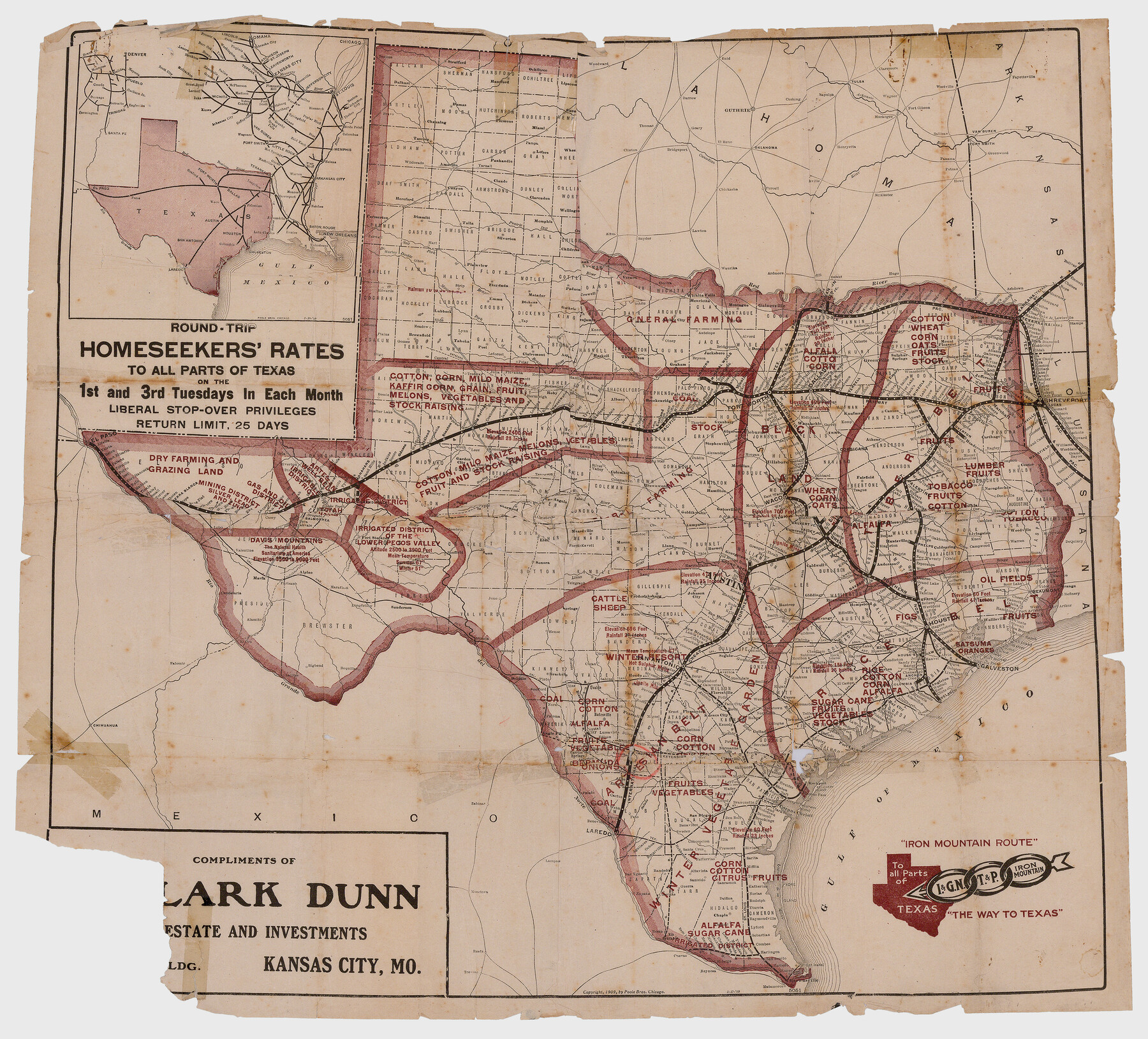
"Iron Mountain Route" to all parts of Texas - I. & G. N., T. & P., Iron Mountain - "The Way to Texas"
-
Map/Doc
95793
-
Collection
Cobb Digital Map Collection
-
Object Dates
1909 (Creation Date)
-
People and Organizations
Poole Bros. (Publisher)
-
Subjects
Railroads State of Texas
-
Height x Width
21.8 x 24.0 inches
55.4 x 61.0 cm
-
Medium
digital image
-
Comments
Courtesy of John & Diana Cobb.
Part of: Cobb Digital Map Collection
Geographically Correct County Map showing the lines of the Cotton Belt Route and connections

Print $20.00
- Digital $50.00
Geographically Correct County Map showing the lines of the Cotton Belt Route and connections
1902
Size 35.9 x 30.7 inches
Map/Doc 95840
Health Wealth and Happiness in the Texas Panhandle

Health Wealth and Happiness in the Texas Panhandle
1906
Map/Doc 96753
The Industrial Evolution of the agricultural wonderland of the southwest

Print $20.00
- Digital $50.00
The Industrial Evolution of the agricultural wonderland of the southwest
1927
Size 13.7 x 16.7 inches
Map/Doc 96760
[Plat map of Provident City and surrounding] / Map showing the Gulf Coast Country and Railways and Water Shipping Facilities of the Provident Land Tract
![95819, [Plat map of Provident City and surrounding] / Map showing the Gulf Coast Country and Railways and Water Shipping Facilities of the Provident Land Tract, Cobb Digital Map Collection](https://historictexasmaps.com/wmedia_w700/maps/95819.tif.jpg)
Print $20.00
- Digital $50.00
[Plat map of Provident City and surrounding] / Map showing the Gulf Coast Country and Railways and Water Shipping Facilities of the Provident Land Tract
1908
Size 22.0 x 22.9 inches
Map/Doc 95819
Corpus Christi, Where Texas Meets the Sea

Corpus Christi, Where Texas Meets the Sea
1927
Size 9.6 x 4.3 inches
Map/Doc 97064

[Map of Kentucky and Tennessee]
![96623, [Map of Kentucky and Tennessee], Cobb Digital Map Collection](https://historictexasmaps.com/wmedia_w700/maps/96623.tif.jpg)
Print $20.00
- Digital $50.00
[Map of Kentucky and Tennessee]
1869
Size 8.9 x 9.5 inches
Map/Doc 96623
Geological Map of the route explored by Capt. Jno. Pope, Corps of Topl. Engrs. near the 32nd Parallel of North Latitude from the Red River to the Rio Grande

Print $20.00
- Digital $50.00
Geological Map of the route explored by Capt. Jno. Pope, Corps of Topl. Engrs. near the 32nd Parallel of North Latitude from the Red River to the Rio Grande
1854
Size 11.1 x 24.8 inches
Map/Doc 95751

The Texas and Oklahoma Official Railway & Hotel Guide Map

Print $20.00
- Digital $50.00
The Texas and Oklahoma Official Railway & Hotel Guide Map
1918
Size 23.4 x 24.0 inches
Map/Doc 95893
Map of the State of Texas

Print $20.00
- Digital $50.00
Map of the State of Texas
1876
Size 13.0 x 16.3 inches
Map/Doc 95891
Correct Map of the Railway & Steamship Lines operated by the Southern Pacific Company

Print $20.00
- Digital $50.00
Correct Map of the Railway & Steamship Lines operated by the Southern Pacific Company
1893
Size 16.7 x 40.1 inches
Map/Doc 95762
You may also like
Map of South America engraved to illustrate Mitchell's new intermediate geography

Print $20.00
- Digital $50.00
Map of South America engraved to illustrate Mitchell's new intermediate geography
1885
Size 12.2 x 9.0 inches
Map/Doc 93525
Runnels County Working Sketch Graphic Index

Print $20.00
- Digital $50.00
Runnels County Working Sketch Graphic Index
1948
Size 46.8 x 36.9 inches
Map/Doc 76687
Presidio County Working Sketch Graphic Index, West Part, Sheet 1 (Sketches 1 to 74)

Print $20.00
- Digital $50.00
Presidio County Working Sketch Graphic Index, West Part, Sheet 1 (Sketches 1 to 74)
1974
Size 40.3 x 31.4 inches
Map/Doc 76672
Maps of Gulf Intracoastal Waterway, Texas - Sabine River to the Rio Grande and connecting waterways including ship channels

Print $20.00
- Digital $50.00
Maps of Gulf Intracoastal Waterway, Texas - Sabine River to the Rio Grande and connecting waterways including ship channels
1966
Size 14.6 x 22.3 inches
Map/Doc 61950
Hardin County Working Sketch 24

Print $20.00
- Digital $50.00
Hardin County Working Sketch 24
1950
Size 15.3 x 11.9 inches
Map/Doc 63422
[Surveys near Onion Creek]
![108, [Surveys near Onion Creek], General Map Collection](https://historictexasmaps.com/wmedia_w700/maps/108-1.tif.jpg)
Print $2.00
- Digital $50.00
[Surveys near Onion Creek]
1841
Size 11.0 x 7.8 inches
Map/Doc 108
Hemphill County Sketch File 6

Print $8.00
- Digital $50.00
Hemphill County Sketch File 6
1902
Size 14.2 x 8.6 inches
Map/Doc 26299
Taylor County Rolled Sketch 28

Print $20.00
- Digital $50.00
Taylor County Rolled Sketch 28
Size 34.4 x 23.9 inches
Map/Doc 7921

Nueces County Rolled Sketch 12

Print $40.00
- Digital $50.00
Nueces County Rolled Sketch 12
Size 40.3 x 54.1 inches
Map/Doc 9587
[Blocks 3T, 1, and 6T]
![91421, [Blocks 3T, 1, and 6T], Twichell Survey Records](https://historictexasmaps.com/wmedia_w700/maps/91421-1.tif.jpg)
Print $20.00
- Digital $50.00
[Blocks 3T, 1, and 6T]
Size 26.2 x 25.7 inches
Map/Doc 91421
Brewster County Rolled Sketch 123

Print $25.00
- Digital $50.00
Brewster County Rolled Sketch 123
Size 10.1 x 15.3 inches
Map/Doc 43129