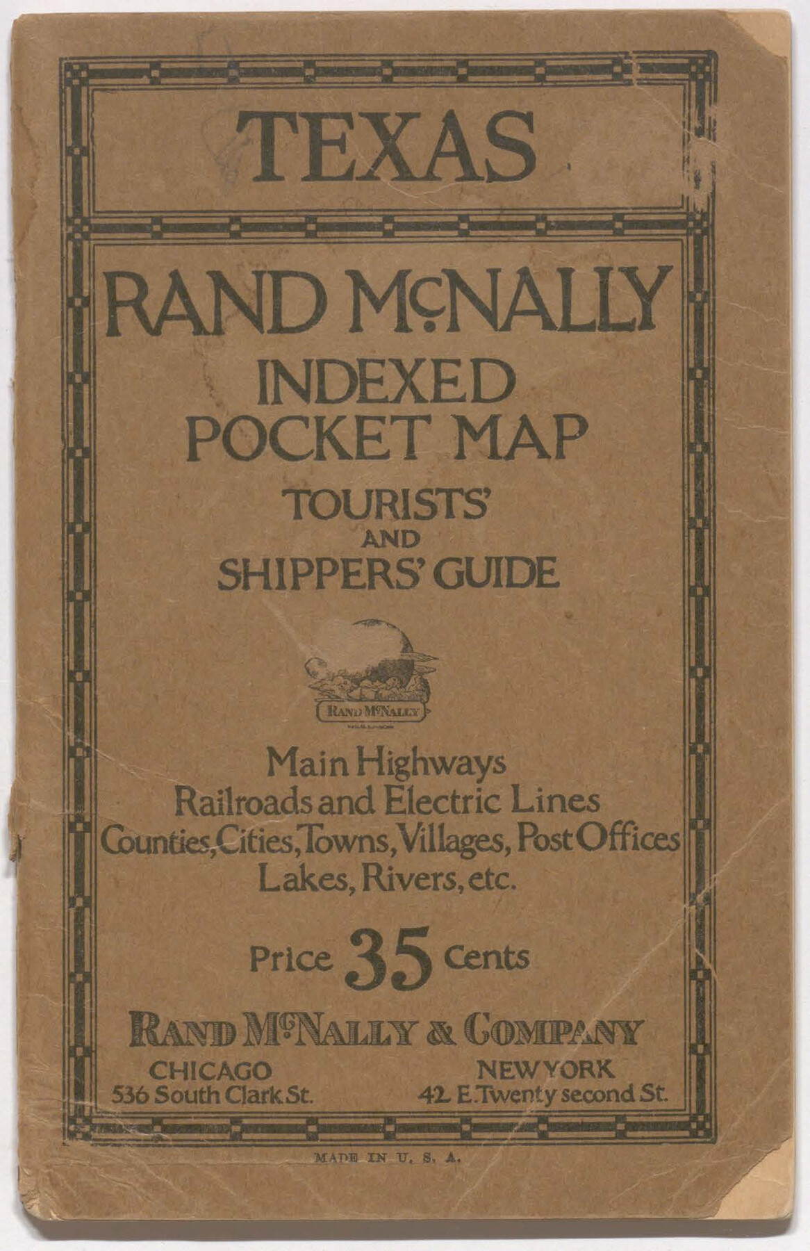
Texas - Rand McNally Indexed Pocket Map - Tourists' and Shippers' Guide - Main Highways, Railroads, and Electric Lines, Counties, Cities, Towns, Villages, Post Offices, Lakes, Rivers, etc.
-
Map/Doc
95854
-
Collection
Cobb Digital Map Collection
-
Object Dates
1924 (Creation Date)
-
People and Organizations
Rand, McNally & Co. (Publisher)
-
Subjects
Bound Volume Railroads
-
Medium
pdf
-
Comments
Courtesy of John & Diana Cobb. Booklet only, no map.
Part of: Cobb Digital Map Collection
Map of the State of Texas

Print $20.00
- Digital $50.00
Map of the State of Texas
1876
Size 13.0 x 16.3 inches
Map/Doc 95891

A Splendid Endorsement of the Red River Valley Lands in the Famous Red River Valley of North Texas

Print $20.00
- Digital $50.00
A Splendid Endorsement of the Red River Valley Lands in the Famous Red River Valley of North Texas
1901
Size 10.2 x 12.7 inches
Map/Doc 96601

The Newest Land Of Promise - The Pecos Valley in Texas

Print $20.00
- Digital $50.00
The Newest Land Of Promise - The Pecos Valley in Texas
1900
Size 17.8 x 22.9 inches
Map/Doc 97038
Geographically Correct County Map showing the lines of the Cotton Belt Route and connections

Print $20.00
- Digital $50.00
Geographically Correct County Map showing the lines of the Cotton Belt Route and connections
1902
Size 35.9 x 30.7 inches
Map/Doc 95840
Texas: Her Resources and Capabilities: being a description of the State of Texas and the inducements She offers to those seeking homes in a new country

Texas: Her Resources and Capabilities: being a description of the State of Texas and the inducements She offers to those seeking homes in a new country
1881
Size 9.3 x 6.1 inches
Map/Doc 96615
The Beautiful Valley of the Lower Rio Grande of Texas

The Beautiful Valley of the Lower Rio Grande of Texas
1928
Map/Doc 96739
Your Opportunity - the Magic Valley - Money Will Grow on Trees! Learn Where How and Why!

Your Opportunity - the Magic Valley - Money Will Grow on Trees! Learn Where How and Why!
1928
Map/Doc 96740
The "Magic Valley" of the Lower Rio Grande - the Land of Golden Fruit

The "Magic Valley" of the Lower Rio Grande - the Land of Golden Fruit
1930
Map/Doc 96745

Map of the Great Air Line Route, Ohio & Mississippi Railway and connections

Print $20.00
- Digital $50.00
Map of the Great Air Line Route, Ohio & Mississippi Railway and connections
1878
Size 12.8 x 26.4 inches
Map/Doc 95820
You may also like
Crockett County Rolled Sketch 58

Print $20.00
- Digital $50.00
Crockett County Rolled Sketch 58
Size 19.0 x 32.8 inches
Map/Doc 5600
El Paso County Sketch File 35 (1)

Print $8.00
- Digital $50.00
El Paso County Sketch File 35 (1)
Size 13.0 x 8.3 inches
Map/Doc 22166

San Patricio County Rolled Sketch 33

Print $141.00
- Digital $50.00
San Patricio County Rolled Sketch 33
Size 10.2 x 15.0 inches
Map/Doc 48874
Coast Chart No. 210 Aransas Pass and Corpus Christi Bay with the coast to latitude 27° 12' Texas

Print $20.00
- Digital $50.00
Coast Chart No. 210 Aransas Pass and Corpus Christi Bay with the coast to latitude 27° 12' Texas
1887
Size 27.1 x 18.3 inches
Map/Doc 72804
Flight Mission No. DQN-5K, Frame 23, Calhoun County

Print $20.00
- Digital $50.00
Flight Mission No. DQN-5K, Frame 23, Calhoun County
1953
Size 18.5 x 22.1 inches
Map/Doc 84374
Railroad Track Map, H&TCRRCo., Falls County, Texas

Print $4.00
- Digital $50.00
Railroad Track Map, H&TCRRCo., Falls County, Texas
1918
Size 11.6 x 18.6 inches
Map/Doc 62848
[Sketch showing Block M-20, Sections 9 through 46 and Block 22, Sections 1 through 12]
![91717, [Sketch showing Block M-20, Sections 9 through 46 and Block 22, Sections 1 through 12], Twichell Survey Records](https://historictexasmaps.com/wmedia_w700/maps/91717-1.tif.jpg)
Print $3.00
- Digital $50.00
[Sketch showing Block M-20, Sections 9 through 46 and Block 22, Sections 1 through 12]
Size 10.9 x 13.9 inches
Map/Doc 91717
Flight Mission No. CGI-4N, Frame 192, Cameron County

Print $20.00
- Digital $50.00
Flight Mission No. CGI-4N, Frame 192, Cameron County
1955
Size 18.6 x 22.2 inches
Map/Doc 84695
Cottle County Sketch File 6

Print $20.00
- Digital $50.00
Cottle County Sketch File 6
1883
Size 20.3 x 29.8 inches
Map/Doc 11190
Aransas County NRC Article 33.136 Sketch 15

Print $42.00
- Digital $50.00
Aransas County NRC Article 33.136 Sketch 15
Size 24.0 x 36.0 inches
Map/Doc 95316
From Citizens to Redefine the Boundary Between Gonzales and Victoria Counties, April 14, 18

Print $20.00
From Citizens to Redefine the Boundary Between Gonzales and Victoria Counties, April 14, 18
2020
Size 24.9 x 21.7 inches
Map/Doc 96378