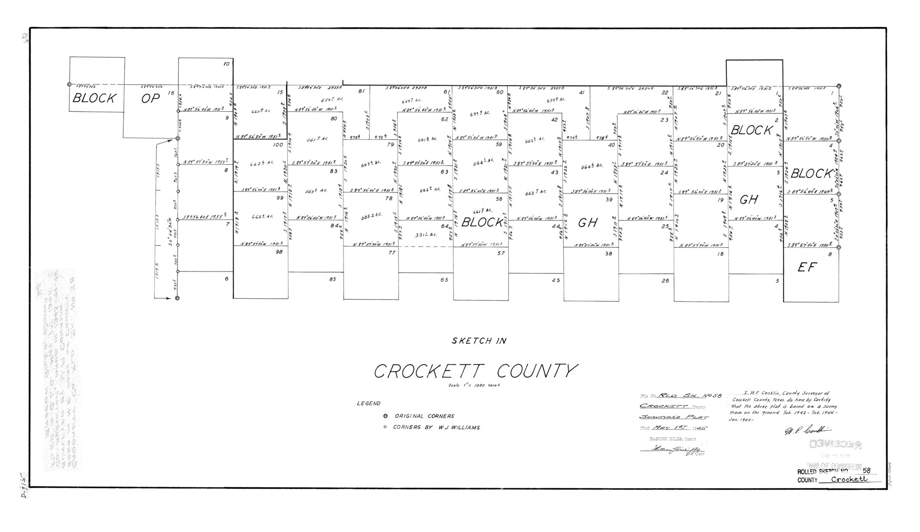
Crockett County Rolled Sketch 58
Sketch in Crockett County
-
Map/Doc
5600
-
Collection
General Map Collection
-
Object Dates
1945 (Survey Date)
1945/5/1 (File Date)
-
People and Organizations
W.P. Conklin (Surveyor/Engineer)
-
Counties
Crockett
-
Subjects
Surveying Rolled Sketch
-
Height x Width
19.0 x 32.8 inches
48.3 x 83.3 cm
-
Scale
1" = 1000 varas
Part of: General Map Collection
Van Zandt County Working Sketch 10

Print $20.00
- Digital $50.00
Van Zandt County Working Sketch 10
1982
Size 12.4 x 13.1 inches
Map/Doc 72260
Maverick County Sketch File 24

Print $36.00
- Digital $50.00
Maverick County Sketch File 24
1890
Size 9.1 x 8.7 inches
Map/Doc 31145
Parker County Sketch File 4

Print $6.00
- Digital $50.00
Parker County Sketch File 4
1856
Size 6.2 x 5.8 inches
Map/Doc 33525
Galveston County Sketch File 70

Print $26.00
- Digital $50.00
Galveston County Sketch File 70
1983
Size 11.3 x 8.7 inches
Map/Doc 23928
Medina County Rolled Sketch 3

Print $40.00
- Digital $50.00
Medina County Rolled Sketch 3
Size 40.9 x 54.5 inches
Map/Doc 9504
Callahan County Sketch File 12

Print $40.00
- Digital $50.00
Callahan County Sketch File 12
1872
Size 17.8 x 26.2 inches
Map/Doc 11041
Erath County Sketch File 15

Print $4.00
- Digital $50.00
Erath County Sketch File 15
1872
Size 6.2 x 7.6 inches
Map/Doc 22292
Brazoria County Sketch File 37

Print $40.00
- Digital $50.00
Brazoria County Sketch File 37
1916
Size 20.6 x 30.1 inches
Map/Doc 10959
[Map of Surveys in Dallam, Texas]
![1768, [Map of Surveys in Dallam, Texas], General Map Collection](https://historictexasmaps.com/wmedia_w700/maps/1768.tif.jpg)
Print $20.00
- Digital $50.00
[Map of Surveys in Dallam, Texas]
1910
Size 19.5 x 27.8 inches
Map/Doc 1768
Leon County Rolled Sketch 5

Print $20.00
- Digital $50.00
Leon County Rolled Sketch 5
1947
Size 33.7 x 34.8 inches
Map/Doc 9427

Hardin County Sketch File 7

Print $6.00
- Digital $50.00
Hardin County Sketch File 7
Size 7.2 x 5.9 inches
Map/Doc 25099
You may also like
English Field Notes of the Spanish Archives - Book 5

English Field Notes of the Spanish Archives - Book 5
1835
Map/Doc 96531
Orange County Sketch File 27

Print $20.00
- Digital $50.00
Orange County Sketch File 27
1915
Size 18.6 x 21.8 inches
Map/Doc 12123
Sketch from the map of Bailey Co.

Print $2.00
- Digital $50.00
Sketch from the map of Bailey Co.
Size 8.4 x 7.6 inches
Map/Doc 464
La Salle County Sketch File 39

Print $6.00
- Digital $50.00
La Salle County Sketch File 39
1912
Size 16.4 x 11.4 inches
Map/Doc 29592
Reeves County Rolled Sketch 33

Print $20.00
- Digital $50.00
Reeves County Rolled Sketch 33
Size 24.9 x 36.8 inches
Map/Doc 7503
Foard County Boundary File 4

Print $24.00
- Digital $50.00
Foard County Boundary File 4
Size 14.2 x 8.8 inches
Map/Doc 53524
The Republic County of Shelby. January 28, 1839

Print $20.00
The Republic County of Shelby. January 28, 1839
2020
Size 21.1 x 21.7 inches
Map/Doc 96281
Dawson County Sketch File A

Print $28.00
- Digital $50.00
Dawson County Sketch File A
1903
Size 11.4 x 8.8 inches
Map/Doc 20461
Webb County Sketch File 12d

Print $20.00
- Digital $50.00
Webb County Sketch File 12d
1886
Size 17.0 x 17.9 inches
Map/Doc 12629
Terrell County Rolled Sketch 41

Print $20.00
- Digital $50.00
Terrell County Rolled Sketch 41
Size 18.6 x 34.3 inches
Map/Doc 9990
Map of Cooke County

Print $20.00
- Digital $50.00
Map of Cooke County
1857
Size 34.1 x 37.9 inches
Map/Doc 1973
W.D. Twichell's and R.S. Hunnicutt's Resurvey in Oldham County, Texas May to October 1915

Print $20.00
- Digital $50.00
W.D. Twichell's and R.S. Hunnicutt's Resurvey in Oldham County, Texas May to October 1915
1915
Size 47.6 x 38.3 inches
Map/Doc 89970