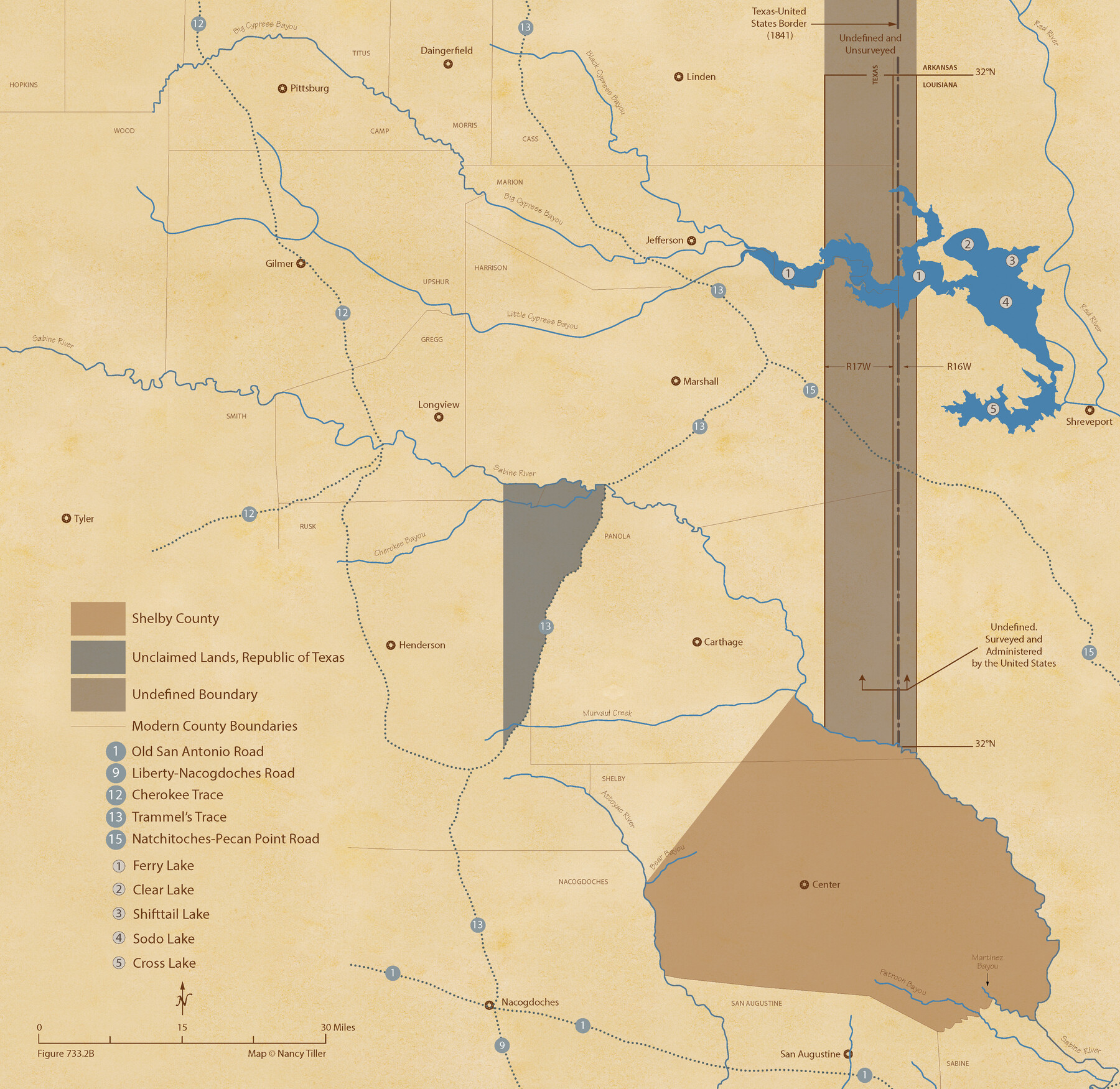
The Republic County of Shelby. January 28, 1839
Figure No. 733.2 from 'A Boundary Atlas of Texas, 1821-1845' by Jim Tiller
-
Map/Doc
96281
-
Collection
Nancy and Jim Tiller Digital Collection
-
Object Dates
2020/1/1 (Creation Date)
-
People and Organizations
Jim Tiller (Author)
Nancy Tiller (Cartographer)
Gang Gong (GIS Professional)
-
Counties
Shelby
-
Subjects
Atlas County Republic of Texas Texas Boundaries
-
Height x Width
21.1 x 21.7 inches
53.6 x 55.1 cm
-
Medium
digital image
-
Comments
To purchase a digital PDF copy of "A Boundary Atlas of Texas, 1821-1845" see 96437.
Part of: Nancy and Jim Tiller Digital Collection
The Republic County of Shelby. December 31, 1844

Print $20.00
The Republic County of Shelby. December 31, 1844
2020
Size 20.0 x 21.7 inches
Map/Doc 96286
The Republic County of San Patricio. December 31, 1838

Print $20.00
The Republic County of San Patricio. December 31, 1838
2020
Size 22.2 x 21.7 inches
Map/Doc 96275
From Citizens of Brazoria County to Annex the Island of San Luis, December 12, 1839

Print $20.00
From Citizens of Brazoria County to Annex the Island of San Luis, December 12, 1839
2020
Size 13.8 x 21.7 inches
Map/Doc 96387
The Judicial District/County of Menard. December 7, 1841

Print $20.00
The Judicial District/County of Menard. December 7, 1841
2020
Size 22.4 x 21.7 inches
Map/Doc 96336
The Republic County of Harris. January 25, 1840

Print $20.00
The Republic County of Harris. January 25, 1840
2020
Size 17.7 x 21.7 inches
Map/Doc 96165
The Chief Justice Counties. Late Summer 1837

Print $20.00
The Chief Justice Counties. Late Summer 1837
2020
Size 16.8 x 19.1 inches
Map/Doc 96079
The Republic County of Gonzales. December 18, 1837

Print $20.00
The Republic County of Gonzales. December 18, 1837
2020
Size 14.7 x 21.7 inches
Map/Doc 96154
The Republic County of Matagorda. Refined, January 25, 1841

Print $20.00
The Republic County of Matagorda. Refined, January 25, 1841
2020
Size 19.3 x 21.8 inches
Map/Doc 96221
The Land Offices. No. 3, Liberty, December 22, 1836

Print $20.00
The Land Offices. No. 3, Liberty, December 22, 1836
2020
Size 16.0 x 21.7 inches
Map/Doc 96416

The Republic County of Gonzales. January 29, 1842

Print $20.00
The Republic County of Gonzales. January 29, 1842
2020
Size 14.7 x 21.7 inches
Map/Doc 96157
The Republic County of Victoria. December 29, 1845

Print $20.00
The Republic County of Victoria. December 29, 1845
2020
Size 24.3 x 21.7 inches
Map/Doc 96301
You may also like
A Part of Blocks 31 and 32 Township 5 North

Print $20.00
- Digital $50.00
A Part of Blocks 31 and 32 Township 5 North
Size 19.6 x 23.8 inches
Map/Doc 92458
Gregg County Rolled Sketch 20

Print $20.00
- Digital $50.00
Gregg County Rolled Sketch 20
1957
Size 34.0 x 44.4 inches
Map/Doc 9070
Kent County Sketch File 10

Print $42.00
- Digital $50.00
Kent County Sketch File 10
1924
Size 22.1 x 35.5 inches
Map/Doc 11914
The Republic County of Refugio. Proposed, Late Fall 1837

Print $20.00
The Republic County of Refugio. Proposed, Late Fall 1837
2020
Size 22.3 x 21.6 inches
Map/Doc 96256
Upton County Working Sketch 4

Print $20.00
- Digital $50.00
Upton County Working Sketch 4
Size 21.8 x 33.9 inches
Map/Doc 69500

Oil Fields of the Texas-Louisiana Gulf Coastal Plain

Oil Fields of the Texas-Louisiana Gulf Coastal Plain
1903
Map/Doc 97518
Hamilton County Rolled Sketch 13

Print $20.00
- Digital $50.00
Hamilton County Rolled Sketch 13
1982
Size 34.0 x 28.0 inches
Map/Doc 6062
Coryell County Sketch File 2

Print $4.00
- Digital $50.00
Coryell County Sketch File 2
Size 13.0 x 8.0 inches
Map/Doc 19338

Lipscomb County Sketch File 3

Print $20.00
- Digital $50.00
Lipscomb County Sketch File 3
Size 36.5 x 8.4 inches
Map/Doc 10526
Liberty County Working Sketch 67

Print $20.00
- Digital $50.00
Liberty County Working Sketch 67
1971
Size 35.3 x 44.5 inches
Map/Doc 70527