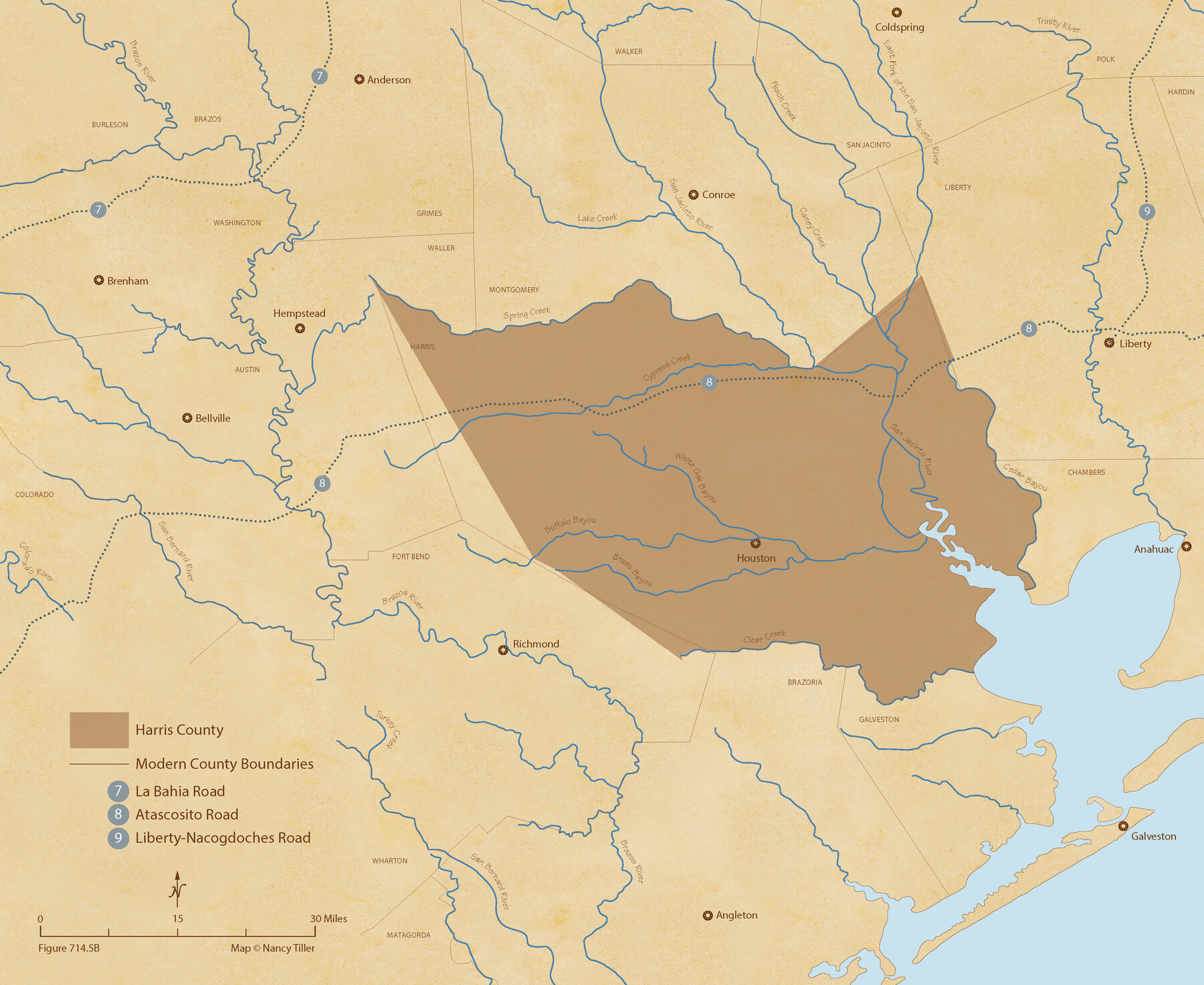
The Republic County of Harris. January 25, 1840
Figure No. 714.5 from 'A Boundary Atlas of Texas, 1821-1845' by Jim Tiller
-
Map/Doc
96165
-
Collection
Nancy and Jim Tiller Digital Collection
-
Object Dates
2020/1/1 (Creation Date)
-
People and Organizations
Jim Tiller (Author)
Nancy Tiller (Cartographer)
Gang Gong (GIS Professional)
-
Counties
Harris
-
Subjects
Atlas County Republic of Texas Texas Boundaries
-
Height x Width
17.7 x 21.7 inches
45.0 x 55.1 cm
-
Medium
digital image
-
Comments
To purchase a digital PDF copy of "A Boundary Atlas of Texas, 1821-1845" see 96437.
Part of: Nancy and Jim Tiller Digital Collection
The Judicial District/County of Panola. Abolished, Spring 1842

Print $20.00
The Judicial District/County of Panola. Abolished, Spring 1842
2020
Size 19.3 x 21.7 inches
Map/Doc 96342
The Republic County of Jasper. Boundaries Defined, December 14, 1837

Print $20.00
The Republic County of Jasper. Boundaries Defined, December 14, 1837
2020
Size 19.5 x 21.7 inches
Map/Doc 96193
The Mexican Municipality of Mina. January 11, 1836

Print $20.00
The Mexican Municipality of Mina. January 11, 1836
2020
Size 10.7 x 21.7 inches
Map/Doc 96030
From Citizens Living in Red River County for the Creation of a New County (Unnamed), Undated

Print $20.00
From Citizens Living in Red River County for the Creation of a New County (Unnamed), Undated
2020
Size 16.6 x 21.7 inches
Map/Doc 96405
Republic Counties. January 1, 1839

Print $20.00
Republic Counties. January 1, 1839
2020
Size 24.5 x 21.7 inches
Map/Doc 96312
Leftwich Empresario Colony. April 15, 1825

Print $20.00
Leftwich Empresario Colony. April 15, 1825
2020
Size 19.5 x 21.7 inches
Map/Doc 95997
The Republic County of Harris. Proposed, Late Fall 1837-May 15, 1838

Print $20.00
The Republic County of Harris. Proposed, Late Fall 1837-May 15, 1838
2020
Size 17.7 x 21.7 inches
Map/Doc 96162
The Republic County of Gonzales. May 3, 1838

Print $20.00
The Republic County of Gonzales. May 3, 1838
2020
Size 14.7 x 21.7 inches
Map/Doc 96155
DeWitt Empresario Colony. April 15, 1825

Print $20.00
DeWitt Empresario Colony. April 15, 1825
2020
Size 18.1 x 21.7 inches
Map/Doc 95991
The Chief Justice County of Milam. April 16, 1837

Print $20.00
The Chief Justice County of Milam. April 16, 1837
2020
Size 16.8 x 21.7 inches
Map/Doc 96059
A Boundary Atlas of Texas, 1821-1845

Digital $50.00
A Boundary Atlas of Texas, 1821-1845
2020
Map/Doc 96437
From Citizens of Victoria County to Redefine the Boundary Between Jackson and Victoria Counties, November 25, 1841

Print $20.00
From Citizens of Victoria County to Redefine the Boundary Between Jackson and Victoria Counties, November 25, 1841
2020
Size 23.3 x 21.7 inches
Map/Doc 96394
You may also like
Estes Quadrangle

Print $20.00
- Digital $50.00
Estes Quadrangle
1971
Size 27.8 x 23.6 inches
Map/Doc 73442
Red River County Working Sketch 1

Print $20.00
- Digital $50.00
Red River County Working Sketch 1
1918
Size 26.8 x 22.1 inches
Map/Doc 71984
Nueces County Rolled Sketch 12

Print $40.00
- Digital $50.00
Nueces County Rolled Sketch 12
Size 40.3 x 54.1 inches
Map/Doc 9587
Liberty County Working Sketch 23

Print $20.00
- Digital $50.00
Liberty County Working Sketch 23
1941
Size 29.9 x 26.4 inches
Map/Doc 70482
General Highway Map, Throckmorton County, Texas

Print $20.00
General Highway Map, Throckmorton County, Texas
1940
Size 24.9 x 18.2 inches
Map/Doc 79258
Bosque County Working Sketch 9

Print $20.00
- Digital $50.00
Bosque County Working Sketch 9
1943
Size 11.2 x 18.3 inches
Map/Doc 67442
[T. & P. Block U and H. & T. C. Block 1]
![91871, [T. & P. Block U and H. & T. C. Block 1], Twichell Survey Records](https://historictexasmaps.com/wmedia_w700/maps/91871-1.tif.jpg)
Print $20.00
- Digital $50.00
[T. & P. Block U and H. & T. C. Block 1]
Size 20.5 x 16.7 inches
Map/Doc 91871

Aransas County Working Sketch 14

Print $20.00
- Digital $50.00
Aransas County Working Sketch 14
1951
Size 22.5 x 22.3 inches
Map/Doc 67181
Flight Mission No. DIX-10P, Frame 72, Aransas County

Print $20.00
- Digital $50.00
Flight Mission No. DIX-10P, Frame 72, Aransas County
1956
Size 18.8 x 22.4 inches
Map/Doc 83933
Johnson County Sketch File 1

Print $48.00
- Digital $50.00
Johnson County Sketch File 1
Size 8.0 x 6.9 inches
Map/Doc 28427
Leon County Sketch File 34

Print $10.00
- Digital $50.00
Leon County Sketch File 34
1962
Size 11.1 x 8.7 inches
Map/Doc 94787