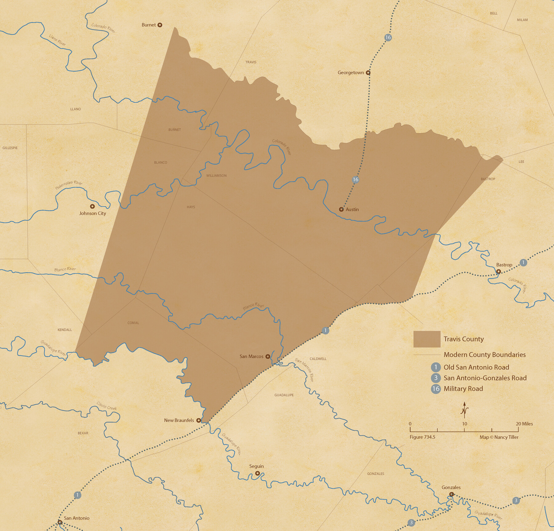
The Republic County of Travis. December 29, 1845
Figure No. 734.5 from 'A Boundary Atlas of Texas, 1821-1845' by Jim Tiller
-
Map/Doc
96293
-
Collection
Nancy and Jim Tiller Digital Collection
-
Object Dates
2020/1/1 (Creation Date)
-
People and Organizations
Jim Tiller (Author)
Nancy Tiller (Cartographer)
Gang Gong (GIS Professional)
-
Counties
Travis
-
Subjects
Atlas County Republic of Texas Texas Boundaries
-
Height x Width
20.8 x 21.6 inches
52.8 x 54.9 cm
-
Medium
digital image
-
Comments
To purchase a digital PDF copy of "A Boundary Atlas of Texas, 1821-1845" see 96437.
Please note that the labels for Williamson and Travis Counties on this map have been transposed in error.
Part of: Nancy and Jim Tiller Digital Collection
The Chief Justice County of Gonzales. Lands in Conflict with Victoria County

Print $20.00
The Chief Justice County of Gonzales. Lands in Conflict with Victoria County
2020
Size 22.3 x 21.7 inches
Map/Doc 96048
The Republic County of Bowie. Created, December 17, 1840

Print $20.00
The Republic County of Bowie. Created, December 17, 1840
2020
Size 19.5 x 21.7 inches
Map/Doc 96102
The Mexican Department of Bexar. Created, 1827

Print $20.00
The Mexican Department of Bexar. Created, 1827
2020
Size 16.6 x 21.7 inches
Map/Doc 95967
From Citizens to Redefine the Boundary Between Gonzales and Victoria Counties, April 14, 18

Print $20.00
From Citizens to Redefine the Boundary Between Gonzales and Victoria Counties, April 14, 18
2020
Size 24.9 x 21.7 inches
Map/Doc 96378
The Republic County of Brazoria. January 1, 1838

Print $20.00
The Republic County of Brazoria. January 1, 1838
2020
Size 14.7 x 21.8 inches
Map/Doc 96111
Republic Counties. December 29, 1845

Print $20.00
Republic Counties. December 29, 1845
2020
Size 24.5 x 21.7 inches
Map/Doc 96319
The Republic County of Red River. January 28, 1841

Print $20.00
The Republic County of Red River. January 28, 1841
2020
Size 21.0 x 21.7 inches
Map/Doc 96253
The Chief Justice County of Liberty. Lands in Conflict with Harrisburg County

Print $20.00
The Chief Justice County of Liberty. Lands in Conflict with Harrisburg County
2020
Size 20.5 x 21.7 inches
Map/Doc 96056
The Judicial District/County of Panola. Abolished, Spring 1842

Print $20.00
The Judicial District/County of Panola. Abolished, Spring 1842
2020
Size 19.3 x 21.7 inches
Map/Doc 96342
The Chief Justice County of Brazoria. April 24, 1837

Print $20.00
The Chief Justice County of Brazoria. April 24, 1837
2020
Size 14.8 x 21.7 inches
Map/Doc 96042
The Mexican Municipality of San Patricio. April 1834

Print $20.00
The Mexican Municipality of San Patricio. April 1834
2020
Size 16.0 x 21.7 inches
Map/Doc 96034
The Republic County of Red River. December 17, 1840

Print $20.00
The Republic County of Red River. December 17, 1840
2020
Size 17.4 x 21.7 inches
Map/Doc 96252
You may also like
Map of the Country Between the Frontiers of Arkansas and New Mexico embracing the section explored in 1849, 51, and 52

Print $40.00
Map of the Country Between the Frontiers of Arkansas and New Mexico embracing the section explored in 1849, 51, and 52
1852
Size 29.6 x 62.1 inches
Map/Doc 76219
Gillespie County

Print $40.00
- Digital $50.00
Gillespie County
1918
Size 39.6 x 49.5 inches
Map/Doc 66837
Clay County Sketch File 18

Print $4.00
- Digital $50.00
Clay County Sketch File 18
1875
Size 12.6 x 8.4 inches
Map/Doc 18427
Flight Mission No. BQR-3K, Frame 159, Brazoria County

Print $20.00
- Digital $50.00
Flight Mission No. BQR-3K, Frame 159, Brazoria County
1952
Size 18.6 x 22.3 inches
Map/Doc 83986
Trinity River, Extension Crab Tree Ferry Sheet/Red Oak Sheet

Print $4.00
- Digital $50.00
Trinity River, Extension Crab Tree Ferry Sheet/Red Oak Sheet
1922
Size 17.5 x 25.4 inches
Map/Doc 65187
Flight Mission No. CGI-4N, Frame 30, Cameron County

Print $20.00
- Digital $50.00
Flight Mission No. CGI-4N, Frame 30, Cameron County
1954
Size 18.6 x 22.3 inches
Map/Doc 84663
Guadalupe County Sketch File 7

Print $20.00
- Digital $50.00
Guadalupe County Sketch File 7
Size 15.6 x 19.5 inches
Map/Doc 11590
Controlled Mosaic by Jack Amman Photogrammetric Engineers, Inc - Sheet 34

Print $20.00
- Digital $50.00
Controlled Mosaic by Jack Amman Photogrammetric Engineers, Inc - Sheet 34
1954
Size 20.0 x 24.0 inches
Map/Doc 83487
[Capitol Leagues 217-228, 238, and vicinity]
![90693, [Capitol Leagues 217-228, 238, and vicinity], Twichell Survey Records](https://historictexasmaps.com/wmedia_w700/maps/90693-1.tif.jpg)
Print $20.00
- Digital $50.00
[Capitol Leagues 217-228, 238, and vicinity]
Size 24.7 x 10.6 inches
Map/Doc 90693
Frio County Working Sketch 26

Print $20.00
- Digital $50.00
Frio County Working Sketch 26
2001
Size 38.0 x 42.7 inches
Map/Doc 69300
Van Zandt County Sketch File 47

Print $7.00
- Digital $50.00
Van Zandt County Sketch File 47
Size 10.0 x 8.1 inches
Map/Doc 39504
PSL Field Notes for Block B9 in Ector and Winkler Counties, Block B13 in Ector, Ward, and Winkler Counties, and Blocks A55, A56, A57, B1, B2, B3, B5, B6, B7, B10, B11, and B12 in Winkler County

PSL Field Notes for Block B9 in Ector and Winkler Counties, Block B13 in Ector, Ward, and Winkler Counties, and Blocks A55, A56, A57, B1, B2, B3, B5, B6, B7, B10, B11, and B12 in Winkler County
Map/Doc 81676