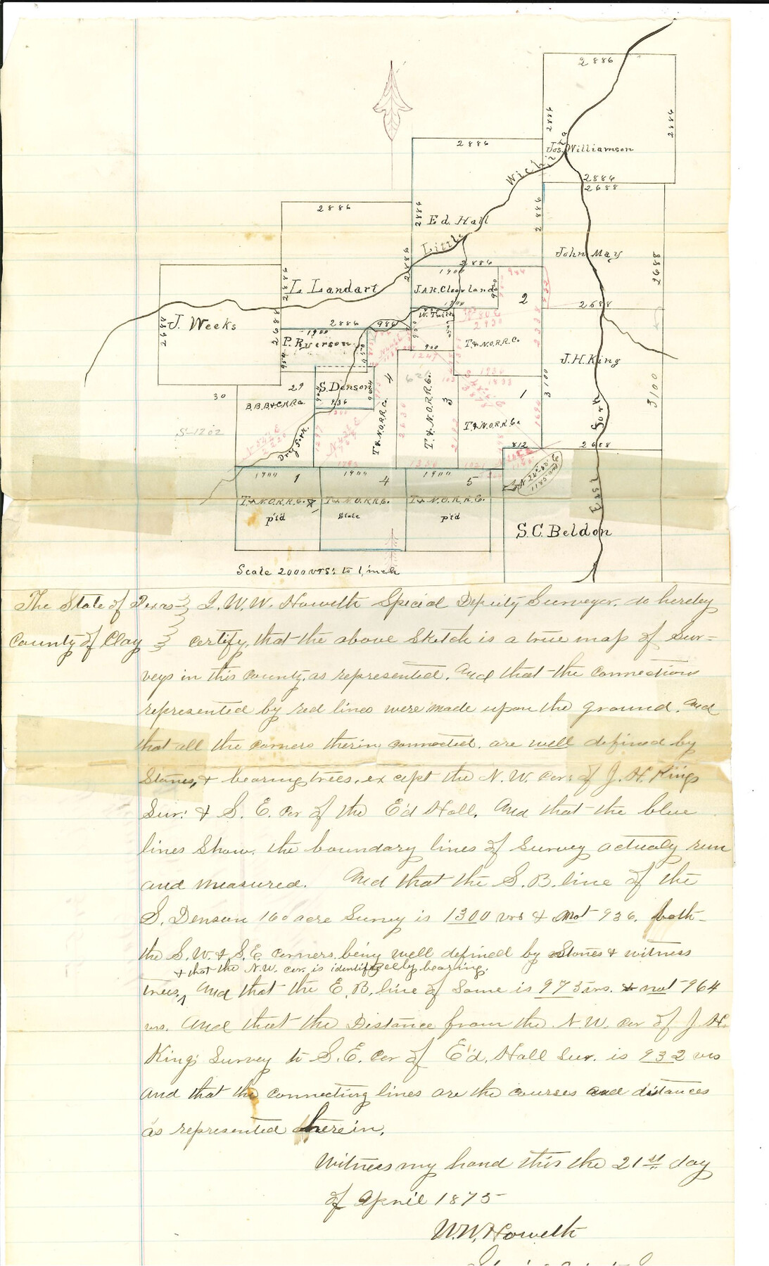
Clay County Sketch File 18
[Sketch of connecting line between surveys on Little Wichita]
-
Map/Doc
18427
-
Collection
General Map Collection
-
Object Dates
4/21/1875 (Creation Date)
5/10/1875 (File Date)
-
People and Organizations
W.W. Howeth (Surveyor/Engineer)
-
Counties
Clay
-
Subjects
Surveying Sketch File
-
Height x Width
12.6 x 8.4 inches
32.0 x 21.3 cm
-
Medium
paper, manuscript
Part of: General Map Collection
Bexar County Rolled Sketch 3

Print $20.00
- Digital $50.00
Bexar County Rolled Sketch 3
1873
Size 25.5 x 18.0 inches
Map/Doc 5136
[Plat of Trinity River w/ Midstream Profile in Liberty County by US Government 1899]
![65340, [Plat of Trinity River w/ Midstream Profile in Liberty County by US Government 1899], General Map Collection](https://historictexasmaps.com/wmedia_w700/maps/65340.tif.jpg)
Print $20.00
- Digital $50.00
[Plat of Trinity River w/ Midstream Profile in Liberty County by US Government 1899]
1899
Size 12.8 x 18.2 inches
Map/Doc 65340
Flight Mission No. DAH-17M, Frame 19, Orange County

Print $20.00
- Digital $50.00
Flight Mission No. DAH-17M, Frame 19, Orange County
1953
Size 18.6 x 22.6 inches
Map/Doc 86882
[Surveys in the Bexar District along the Guadalupe River]
![124, [Surveys in the Bexar District along the Guadalupe River], General Map Collection](https://historictexasmaps.com/wmedia_w700/maps/124.tif.jpg)
Print $3.00
- Digital $50.00
[Surveys in the Bexar District along the Guadalupe River]
1841
Size 17.2 x 10.8 inches
Map/Doc 124
Val Verde County Rolled Sketch 67

Print $20.00
- Digital $50.00
Val Verde County Rolled Sketch 67
1958
Size 24.5 x 31.6 inches
Map/Doc 8130
Jeff Davis County Working Sketch Graphic Index - central part

Print $40.00
- Digital $50.00
Jeff Davis County Working Sketch Graphic Index - central part
1982
Size 55.7 x 42.6 inches
Map/Doc 76593
Shelby County Rolled Sketch 6

Print $20.00
- Digital $50.00
Shelby County Rolled Sketch 6
Size 26.7 x 20.9 inches
Map/Doc 7776
Flight Mission No. BQR-9K, Frame 49, Brazoria County

Print $20.00
- Digital $50.00
Flight Mission No. BQR-9K, Frame 49, Brazoria County
1952
Size 18.6 x 22.3 inches
Map/Doc 84053
Throckmorton County Rolled Sketch 5A

Print $20.00
- Digital $50.00
Throckmorton County Rolled Sketch 5A
2001
Size 25.2 x 36.0 inches
Map/Doc 76406
Knox County Sketch File 1-1a

Print $30.00
- Digital $50.00
Knox County Sketch File 1-1a
1872
Size 8.2 x 12.4 inches
Map/Doc 29212
Dimmit County Rolled Sketch CHM

Print $20.00
- Digital $50.00
Dimmit County Rolled Sketch CHM
1935
Size 38.4 x 43.4 inches
Map/Doc 8795
Bowie County Sketch File 4

Print $4.00
- Digital $50.00
Bowie County Sketch File 4
Size 10.8 x 8.4 inches
Map/Doc 14835
You may also like
Webb County Sketch File 58

Print $10.00
- Digital $50.00
Webb County Sketch File 58
1942
Size 14.4 x 8.9 inches
Map/Doc 39846
Sutton County Working Sketch 24

Print $20.00
- Digital $50.00
Sutton County Working Sketch 24
1985
Size 32.6 x 42.5 inches
Map/Doc 62367
Hamilton County Boundary File 6

Print $4.00
- Digital $50.00
Hamilton County Boundary File 6
Size 11.2 x 8.6 inches
Map/Doc 54225
Lipscomb County Sketch File 2

Print $20.00
- Digital $50.00
Lipscomb County Sketch File 2
1902
Size 10.7 x 8.2 inches
Map/Doc 30223
Flight Mission No. BQR-13K, Frame 21, Brazoria County

Print $20.00
- Digital $50.00
Flight Mission No. BQR-13K, Frame 21, Brazoria County
1952
Size 18.8 x 22.4 inches
Map/Doc 84069
Gonzales County Sketch File 11

Print $4.00
- Digital $50.00
Gonzales County Sketch File 11
1842
Size 12.8 x 7.9 inches
Map/Doc 24392
Runnels County Working Sketch 12

Print $20.00
- Digital $50.00
Runnels County Working Sketch 12
1950
Size 27.7 x 33.0 inches
Map/Doc 63608
Map of C. W. Post's Land in Hockley County, Texas

Print $20.00
- Digital $50.00
Map of C. W. Post's Land in Hockley County, Texas
Size 24.7 x 15.7 inches
Map/Doc 91095
Flight Mission No. CUG-3P, Frame 17, Kleberg County

Print $20.00
- Digital $50.00
Flight Mission No. CUG-3P, Frame 17, Kleberg County
1956
Size 18.6 x 22.3 inches
Map/Doc 86227
Chambers County Rolled Sketch 11

Print $20.00
- Digital $50.00
Chambers County Rolled Sketch 11
Size 20.0 x 26.5 inches
Map/Doc 5424
[State Capitol Leagues along Bailey-Lamb County Line]
![90163, [State Capitol Leagues along Bailey-Lamb County Line], Twichell Survey Records](https://historictexasmaps.com/wmedia_w700/maps/90163-1.tif.jpg)
Print $20.00
- Digital $50.00
[State Capitol Leagues along Bailey-Lamb County Line]
Size 20.7 x 21.3 inches
Map/Doc 90163
Bosque County Sketch File 23

Print $6.00
- Digital $50.00
Bosque County Sketch File 23
1863
Size 10.2 x 8.2 inches
Map/Doc 14806