Hamilton County Boundary File 6
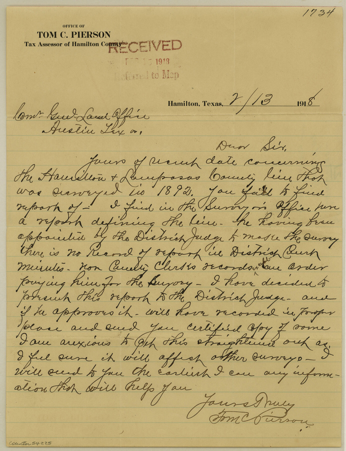
[Letter regarding Hamilton-Lampasas Boundary line]
-
Map/Doc
54225
-
Collection
General Map Collection
-
Counties
Hamilton
-
Subjects
County Boundaries
-
Height x Width
11.2 x 8.6 inches
28.5 x 21.8 cm
Part of: General Map Collection
Flight Mission No. DIX-6P, Frame 180, Aransas County

Print $20.00
- Digital $50.00
Flight Mission No. DIX-6P, Frame 180, Aransas County
1956
Size 19.0 x 22.6 inches
Map/Doc 83842
Tyler County Sketch File 19a

Print $4.00
- Digital $50.00
Tyler County Sketch File 19a
Size 8.1 x 14.1 inches
Map/Doc 38672
Plot of a survey made to connect the surveys in Jackson County with those heretofore made in connection with Colorado County

Print $2.00
- Digital $50.00
Plot of a survey made to connect the surveys in Jackson County with those heretofore made in connection with Colorado County
1847
Size 12.8 x 7.7 inches
Map/Doc 188
Dickens County Rolled Sketch 7

Print $20.00
- Digital $50.00
Dickens County Rolled Sketch 7
1947
Size 33.6 x 23.6 inches
Map/Doc 5706
Brewster County Rolled Sketch 122

Print $20.00
- Digital $50.00
Brewster County Rolled Sketch 122
1974
Size 31.9 x 24.6 inches
Map/Doc 5298
Glasscock County Working Sketch 9

Print $40.00
- Digital $50.00
Glasscock County Working Sketch 9
1957
Size 77.9 x 25.5 inches
Map/Doc 63182
Rusk County Working Sketch 5

Print $20.00
- Digital $50.00
Rusk County Working Sketch 5
1983
Size 33.1 x 25.7 inches
Map/Doc 63640
Reagan County Sketch File 32

Print $6.00
- Digital $50.00
Reagan County Sketch File 32
1954
Size 11.5 x 9.0 inches
Map/Doc 35025

Coke County Rolled Sketch 1

Print $20.00
- Digital $50.00
Coke County Rolled Sketch 1
1943
Size 26.9 x 21.6 inches
Map/Doc 5503
Travis County Sketch File 75B

Print $20.00
- Digital $50.00
Travis County Sketch File 75B
1992
Size 37.4 x 26.7 inches
Map/Doc 12479
Fisher County Sketch File 1

Print $20.00
- Digital $50.00
Fisher County Sketch File 1
Size 43.5 x 18.3 inches
Map/Doc 10448
You may also like
Red River, Kelsey Sheet, Upshur County

Print $4.00
- Digital $50.00
Red River, Kelsey Sheet, Upshur County
1933
Size 21.1 x 24.2 inches
Map/Doc 65056
Fannin County Sketch File 8

Print $4.00
- Digital $50.00
Fannin County Sketch File 8
Size 8.7 x 13.3 inches
Map/Doc 22453
Colorado County Sketch File 12

Print $20.00
- Digital $50.00
Colorado County Sketch File 12
Size 14.6 x 17.8 inches
Map/Doc 11135
San Patricio County Rolled Sketch 49

Print $20.00
- Digital $50.00
San Patricio County Rolled Sketch 49
1979
Size 21.2 x 20.3 inches
Map/Doc 7735
Yoakum County Sketch File 21

Print $2.00
- Digital $50.00
Yoakum County Sketch File 21
2005
Size 8.5 x 14.0 inches
Map/Doc 83597
Flight Mission No. DQN-1K, Frame 122, Calhoun County

Print $20.00
- Digital $50.00
Flight Mission No. DQN-1K, Frame 122, Calhoun County
1953
Size 18.5 x 22.2 inches
Map/Doc 84188

Sterling County Working Sketch 1

Print $20.00
- Digital $50.00
Sterling County Working Sketch 1
1926
Size 30.3 x 29.6 inches
Map/Doc 63983
San Patricio County Sketch File 32

Print $20.00
- Digital $50.00
San Patricio County Sketch File 32
Size 13.7 x 30.3 inches
Map/Doc 12287
Jefferson County Sketch File X

Print $42.00
- Digital $50.00
Jefferson County Sketch File X
Size 17.1 x 13.3 inches
Map/Doc 28087
Harris County Sketch File B

Print $4.00
- Digital $50.00
Harris County Sketch File B
1860
Size 8.0 x 5.5 inches
Map/Doc 25309
Edwards County Working Sketch 28

Print $20.00
- Digital $50.00
Edwards County Working Sketch 28
1946
Size 30.0 x 33.5 inches
Map/Doc 68904