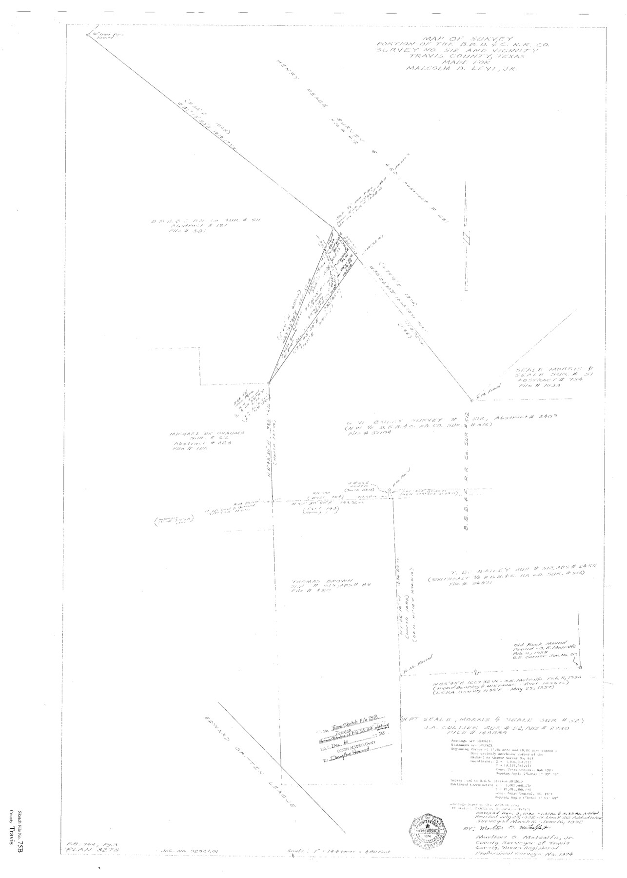
Travis County Sketch File 75B
Map of survey - portion of the B. B. B. & C. R.R. Co. survey no. 512 and vicinity
-
Map/Doc
12479
-
Collection
General Map Collection
-
Object Dates
6/1992 (Creation Date)
12/16/1992 (File Date)
7/23/1992 (Revision Date)
12/9/1992 (Revision Date)
3/16-6/16/1992 (Survey Date)
-
People and Organizations
Marlton O. Metcalfe, Jr. (Surveyor/Engineer)
-
Counties
Travis
-
Subjects
Surveying Sketch File
-
Height x Width
37.4 x 26.7 inches
95.0 x 67.8 cm
-
Medium
paper, print
-
Scale
1" = 144 varas
-
Comments
See SF-16524 and Travis County Rolled Sketch 58 (8049) for sketch.
-
Features
Pedernales River
Related maps
Travis County Rolled Sketch 58

Print $20.00
- Digital $50.00
Travis County Rolled Sketch 58
Size 37.4 x 25.5 inches
Map/Doc 8049
Part of: General Map Collection
Hardeman County Working Sketch 11

Print $40.00
- Digital $50.00
Hardeman County Working Sketch 11
1960
Size 40.0 x 58.1 inches
Map/Doc 63392
Travis County Working Sketch 36

Print $20.00
- Digital $50.00
Travis County Working Sketch 36
1967
Size 23.4 x 30.8 inches
Map/Doc 69420
PSL Field Notes for Blocks B14 and B16 in Crane and Ector Counties, Blocks B18 and B20 in Crane and Ward Counties, and Blocks B17, B21, B22, B23, B24, B25, and B26 in Crane County

PSL Field Notes for Blocks B14 and B16 in Crane and Ector Counties, Blocks B18 and B20 in Crane and Ward Counties, and Blocks B17, B21, B22, B23, B24, B25, and B26 in Crane County
Map/Doc 81646
The North Coast of the Gulf of Mexico from St. Marks to Galveston

Print $20.00
- Digital $50.00
The North Coast of the Gulf of Mexico from St. Marks to Galveston
1844
Size 27.5 x 41.1 inches
Map/Doc 97396
Fort Bend County Sketch File 3a

Print $6.00
- Digital $50.00
Fort Bend County Sketch File 3a
1874
Size 8.3 x 8.0 inches
Map/Doc 22882
Flight Mission No. DQO-8K, Frame 56, Galveston County

Print $20.00
- Digital $50.00
Flight Mission No. DQO-8K, Frame 56, Galveston County
1952
Size 18.7 x 17.6 inches
Map/Doc 85163
Current Miscellaneous File 65

Print $8.00
- Digital $50.00
Current Miscellaneous File 65
Size 11.2 x 8.6 inches
Map/Doc 74109
[Sketch for Mineral Application 1112 - Colorado River, H. E. Chambers]
![65638, [Sketch for Mineral Application 1112 - Colorado River, H. E. Chambers], General Map Collection](https://historictexasmaps.com/wmedia_w700/maps/65638.tif.jpg)
Print $20.00
- Digital $50.00
[Sketch for Mineral Application 1112 - Colorado River, H. E. Chambers]
1918
Size 17.5 x 28.2 inches
Map/Doc 65638
Leon County Working Sketch 3

Print $20.00
- Digital $50.00
Leon County Working Sketch 3
1920
Size 15.9 x 14.4 inches
Map/Doc 70402
Aransas County Working Sketch 19

Print $20.00
- Digital $50.00
Aransas County Working Sketch 19
1978
Size 25.1 x 31.1 inches
Map/Doc 67186
San Jacinto County Rolled Sketch 14

Print $20.00
- Digital $50.00
San Jacinto County Rolled Sketch 14
1998
Size 29.0 x 40.6 inches
Map/Doc 7567
Texas Intracoastal Waterway - Laguna Madre - Dagger Hill to Potrero Grande

Print $20.00
- Digital $50.00
Texas Intracoastal Waterway - Laguna Madre - Dagger Hill to Potrero Grande
1956
Size 38.6 x 27.2 inches
Map/Doc 73509
You may also like
Plat of Land Purchased by C. W. Post in Hockley County, Texas

Print $20.00
- Digital $50.00
Plat of Land Purchased by C. W. Post in Hockley County, Texas
1913
Size 24.1 x 14.5 inches
Map/Doc 91116
Flight Mission No. CLL-4N, Frame 34, Willacy County

Print $20.00
- Digital $50.00
Flight Mission No. CLL-4N, Frame 34, Willacy County
1954
Size 18.4 x 22.2 inches
Map/Doc 87107
Map of that part of Comal County in Bexar District

Print $20.00
- Digital $50.00
Map of that part of Comal County in Bexar District
Size 16.3 x 22.1 inches
Map/Doc 3431
Map of Permanent Lakes & Marshes in Calhoun, Victoria & Jackson Counties for Mineral Development

Print $20.00
- Digital $50.00
Map of Permanent Lakes & Marshes in Calhoun, Victoria & Jackson Counties for Mineral Development
1937
Size 31.3 x 37.2 inches
Map/Doc 3021
Galveston County Sketch File 65

Print $70.00
- Digital $50.00
Galveston County Sketch File 65
1892
Size 8.7 x 5.8 inches
Map/Doc 23717
Official Map of the Highway System of Texas

Print $20.00
Official Map of the Highway System of Texas
1933
Size 26.1 x 27.0 inches
Map/Doc 79308
Flight Mission No. BRE-1P, Frame 72, Nueces County

Print $20.00
- Digital $50.00
Flight Mission No. BRE-1P, Frame 72, Nueces County
1956
Size 18.4 x 22.3 inches
Map/Doc 86654
[Sketch of Fred Turner Survey 7]
![91542, [Sketch of Fred Turner Survey 7], Twichell Survey Records](https://historictexasmaps.com/wmedia_w700/maps/91542-1.tif.jpg)
Print $2.00
- Digital $50.00
[Sketch of Fred Turner Survey 7]
1928
Size 9.0 x 12.2 inches
Map/Doc 91542
Map Showing Position of Surveys Represented Hereon

Print $40.00
- Digital $50.00
Map Showing Position of Surveys Represented Hereon
Size 38.9 x 57.2 inches
Map/Doc 75809
Town of Lubbock, Texas and Additions

Print $20.00
Town of Lubbock, Texas and Additions
1935
Size 43.8 x 43.5 inches
Map/Doc 76271
[Sketch for Mineral Application 16700 - Pecos River Bed]
![2811, [Sketch for Mineral Application 16700 - Pecos River Bed], General Map Collection](https://historictexasmaps.com/wmedia_w700/maps/2811.tif.jpg)
Print $20.00
- Digital $50.00
[Sketch for Mineral Application 16700 - Pecos River Bed]
1927
Size 20.6 x 28.6 inches
Map/Doc 2811
