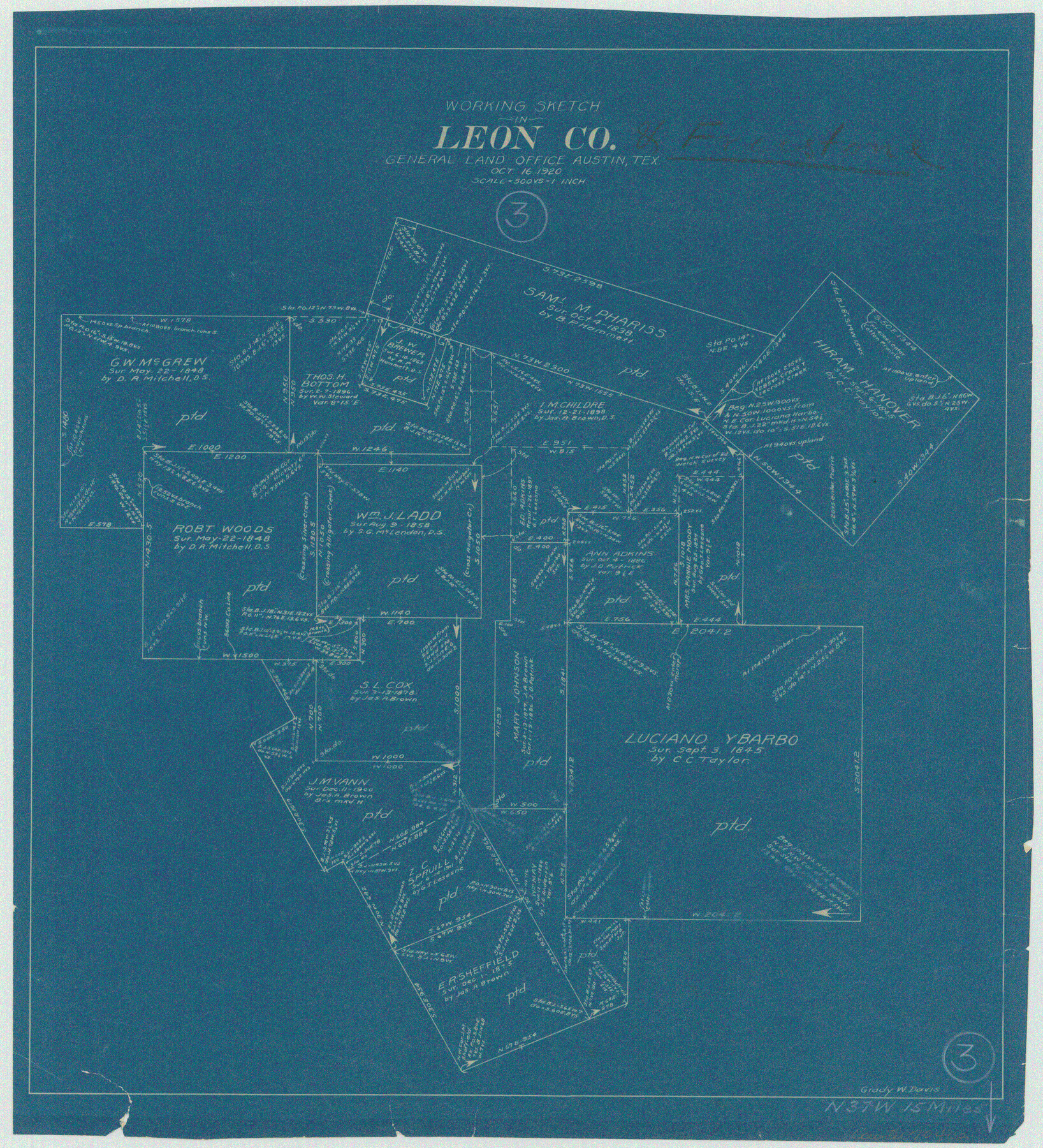
Leon County Working Sketch 3
-
Map/Doc
70402
-
Collection
General Map Collection
-
Object Dates
10/16/1920 (Creation Date)
-
People and Organizations
Grady W. Davis (Draftsman)
-
Counties
Leon
-
Subjects
Surveying Working Sketch
-
Height x Width
15.9 x 14.4 inches
40.4 x 36.6 cm
-
Scale
1" = 500 varas
Part of: General Map Collection
Brazos River, Brazos River Sheet 7

Print $20.00
- Digital $50.00
Brazos River, Brazos River Sheet 7
1926
Size 22.8 x 27.8 inches
Map/Doc 69671
Flight Mission No. BRA-6M, Frame 144, Jefferson County

Print $20.00
- Digital $50.00
Flight Mission No. BRA-6M, Frame 144, Jefferson County
1953
Size 18.5 x 22.3 inches
Map/Doc 85445
Archer County Working Sketch 23

Print $40.00
- Digital $50.00
Archer County Working Sketch 23
1981
Size 31.7 x 48.3 inches
Map/Doc 67164
Crosby County Sketch File 2

Print $22.00
- Digital $50.00
Crosby County Sketch File 2
Size 8.5 x 9.9 inches
Map/Doc 19991
Kinney County Working Sketch 50

Print $20.00
- Digital $50.00
Kinney County Working Sketch 50
1980
Size 19.4 x 26.9 inches
Map/Doc 70232
Ellis County Boundary File 3a

Print $10.00
- Digital $50.00
Ellis County Boundary File 3a
Size 11.2 x 8.9 inches
Map/Doc 52960
Nueces County NRC Article 33.136 Location Key Sheet

Print $20.00
- Digital $50.00
Nueces County NRC Article 33.136 Location Key Sheet
1975
Size 27.0 x 22.8 inches
Map/Doc 77033
Angelina County Sketch File 4

Print $4.00
- Digital $50.00
Angelina County Sketch File 4
1854
Size 8.3 x 9.0 inches
Map/Doc 12926
Blanco County Sketch File 31a

Print $4.00
- Digital $50.00
Blanco County Sketch File 31a
1889
Size 8.6 x 14.1 inches
Map/Doc 14631
Sketch of the route from the camp on the Concho River to Phantom Hill, Texas

Print $20.00
- Digital $50.00
Sketch of the route from the camp on the Concho River to Phantom Hill, Texas
1852
Size 30.0 x 11.9 inches
Map/Doc 2005
Map of South America engraved to illustrate Mitchell's school and family geography

Print $20.00
- Digital $50.00
Map of South America engraved to illustrate Mitchell's school and family geography
1839
Size 11.8 x 9.5 inches
Map/Doc 93501
Mapa del Rio Grande desde su Desembocadura en el Golfo hasta San Vicente, Presidio Antíguo

Print $20.00
- Digital $50.00
Mapa del Rio Grande desde su Desembocadura en el Golfo hasta San Vicente, Presidio Antíguo
1873
Size 38.1 x 32.3 inches
Map/Doc 97126
You may also like
Sutton County Sketch File 14

Print $20.00
- Digital $50.00
Sutton County Sketch File 14
1924
Size 17.8 x 20.0 inches
Map/Doc 12380
Grimes County Working Sketch 18

Print $20.00
- Digital $50.00
Grimes County Working Sketch 18
1990
Size 33.1 x 42.5 inches
Map/Doc 63309
Hemphill County Rolled Sketch 17

Print $40.00
- Digital $50.00
Hemphill County Rolled Sketch 17
1965
Size 24.0 x 64.1 inches
Map/Doc 9157
Sketch of Surveys on Peach Point, J. Perry's Property

Print $20.00
- Digital $50.00
Sketch of Surveys on Peach Point, J. Perry's Property
1832
Size 14.0 x 20.6 inches
Map/Doc 219
Right of Way and Track Map of The Wichita Falls & Southern Railroad Company

Print $40.00
- Digital $50.00
Right of Way and Track Map of The Wichita Falls & Southern Railroad Company
1942
Size 24.6 x 56.1 inches
Map/Doc 64516
[H. &GN Blk. 2, HGN Blk. 1, I, S]
![93212, [H. &GN Blk. 2, HGN Blk. 1, I, S], Twichell Survey Records](https://historictexasmaps.com/wmedia_w700/maps/93212-1.tif.jpg)
Print $40.00
- Digital $50.00
[H. &GN Blk. 2, HGN Blk. 1, I, S]
Size 84.0 x 53.3 inches
Map/Doc 93212
Walker County Sketch File 8

Print $4.00
- Digital $50.00
Walker County Sketch File 8
1944
Size 9.7 x 6.8 inches
Map/Doc 39561
Louisiana and Texas Intracoastal Waterway, Section 7, Galveston Bay to Brazos River and Section 8, Brazos River to Matagorda Bay

Print $20.00
- Digital $50.00
Louisiana and Texas Intracoastal Waterway, Section 7, Galveston Bay to Brazos River and Section 8, Brazos River to Matagorda Bay
1928
Size 30.8 x 42.9 inches
Map/Doc 61839
Hardeman County Working Sketch 1

Print $20.00
- Digital $50.00
Hardeman County Working Sketch 1
Size 16.3 x 21.3 inches
Map/Doc 63382
Johnson County Sketch File 11

Print $8.00
- Digital $50.00
Johnson County Sketch File 11
1880
Size 8.0 x 6.8 inches
Map/Doc 28447
Blanco County Sketch File 36

Print $8.00
- Digital $50.00
Blanco County Sketch File 36
1889
Size 11.2 x 8.8 inches
Map/Doc 14642
General Highway Map, Navarro County, Texas

Print $20.00
General Highway Map, Navarro County, Texas
1939
Size 24.6 x 18.5 inches
Map/Doc 79207