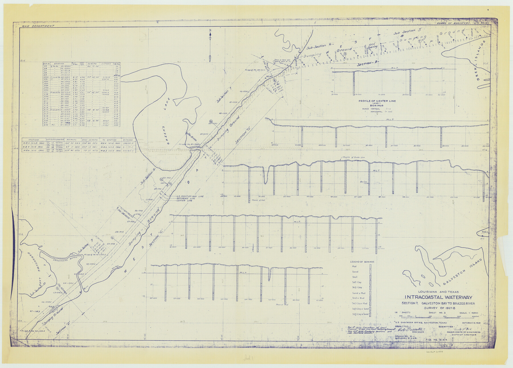
Louisiana and Texas Intracoastal Waterway, Section 7, Galveston Bay to Brazos River and Section 8, Brazos River to Matagorda Bay
-
Map/Doc
61839
-
Collection
General Map Collection
-
Object Dates
1928 (Creation Date)
-
Subjects
Intracoastal Waterways
-
Height x Width
30.8 x 42.9 inches
78.2 x 109.0 cm
Part of: General Map Collection
Map of the Survey of the Parallel 36 1/2 Degrees North Latitude, Commencing at the 100th and Running to the 103rd Degree of Longitude West of Greenwich

Print $40.00
- Digital $50.00
Map of the Survey of the Parallel 36 1/2 Degrees North Latitude, Commencing at the 100th and Running to the 103rd Degree of Longitude West of Greenwich
1862
Size 87.1 x 11.1 inches
Map/Doc 3084
Mills County Working Sketch 22

Print $20.00
- Digital $50.00
Mills County Working Sketch 22
1984
Size 28.7 x 19.8 inches
Map/Doc 71052
Armstrong County

Print $20.00
- Digital $50.00
Armstrong County
1933
Size 42.3 x 41.0 inches
Map/Doc 73071
Nueces County Sketch File 86

Print $2.00
- Digital $50.00
Nueces County Sketch File 86
Map/Doc 81935
Carson County Sketch File 3

Print $32.00
- Digital $50.00
Carson County Sketch File 3
1888
Size 5.4 x 8.4 inches
Map/Doc 17335
Robertson County Sketch File 2

Print $16.00
Robertson County Sketch File 2
1858
Size 10.1 x 8.2 inches
Map/Doc 35343
Flight Mission No. DCL-4C, Frame 7, Kenedy County

Print $20.00
- Digital $50.00
Flight Mission No. DCL-4C, Frame 7, Kenedy County
1943
Size 18.6 x 22.3 inches
Map/Doc 85808
Texas Intracoastal Waterway - Laguna Madre - Rincon de San Jose to Chubby Island

Print $20.00
- Digital $50.00
Texas Intracoastal Waterway - Laguna Madre - Rincon de San Jose to Chubby Island
1957
Size 38.9 x 27.3 inches
Map/Doc 73513
Harris County Working Sketch 63

Print $20.00
- Digital $50.00
Harris County Working Sketch 63
1954
Size 34.0 x 36.8 inches
Map/Doc 65955
Kendall County Sketch File 16a

Print $40.00
- Digital $50.00
Kendall County Sketch File 16a
1891
Size 15.3 x 13.7 inches
Map/Doc 28707
[Galveston, Harrisburg & San Antonio Railroad from Cuero to Stockdale]
![64187, [Galveston, Harrisburg & San Antonio Railroad from Cuero to Stockdale], General Map Collection](https://historictexasmaps.com/wmedia_w700/maps/64187.tif.jpg)
Print $20.00
- Digital $50.00
[Galveston, Harrisburg & San Antonio Railroad from Cuero to Stockdale]
1906
Size 13.3 x 32.9 inches
Map/Doc 64187
Map of Nacogdoches County

Print $40.00
- Digital $50.00
Map of Nacogdoches County
1846
Size 83.7 x 76.1 inches
Map/Doc 82243
You may also like
Tarrant County State Real Property Sketch 3

Print $20.00
- Digital $50.00
Tarrant County State Real Property Sketch 3
2018
Size 35.1 x 23.8 inches
Map/Doc 95402
Ward County Rolled Sketch 24A

Print $20.00
- Digital $50.00
Ward County Rolled Sketch 24A
Size 19.9 x 42.3 inches
Map/Doc 8164
Comal County Working Sketch 8

Print $20.00
- Digital $50.00
Comal County Working Sketch 8
1971
Size 41.6 x 25.6 inches
Map/Doc 68174
Duval County Sketch File 83

Print $20.00
- Digital $50.00
Duval County Sketch File 83
1933
Size 13.7 x 8.8 inches
Map/Doc 21521
Runnels County Rolled Sketch 49

Print $20.00
- Digital $50.00
Runnels County Rolled Sketch 49
Size 28.8 x 29.1 inches
Map/Doc 7534
Flight Mission No. CLL-1N, Frame 197, Willacy County

Print $20.00
- Digital $50.00
Flight Mission No. CLL-1N, Frame 197, Willacy County
1954
Size 18.4 x 22.1 inches
Map/Doc 87067
Briscoe County Sketch File 16

Print $4.00
- Digital $50.00
Briscoe County Sketch File 16
1913
Size 13.4 x 9.1 inches
Map/Doc 16535
Brewster County Sketch File D-1

Print $12.00
- Digital $50.00
Brewster County Sketch File D-1
1909
Size 14.4 x 8.8 inches
Map/Doc 15740
Liberty County Rolled Sketch N

Print $20.00
- Digital $50.00
Liberty County Rolled Sketch N
1954
Size 45.1 x 39.1 inches
Map/Doc 10721
Tarrant County Sketch File 31

Print $20.00
- Digital $50.00
Tarrant County Sketch File 31
Size 27.2 x 39.3 inches
Map/Doc 10380
Hamilton County Boundary File 5

Print $35.00
- Digital $50.00
Hamilton County Boundary File 5
Size 11.1 x 8.6 inches
Map/Doc 54217
