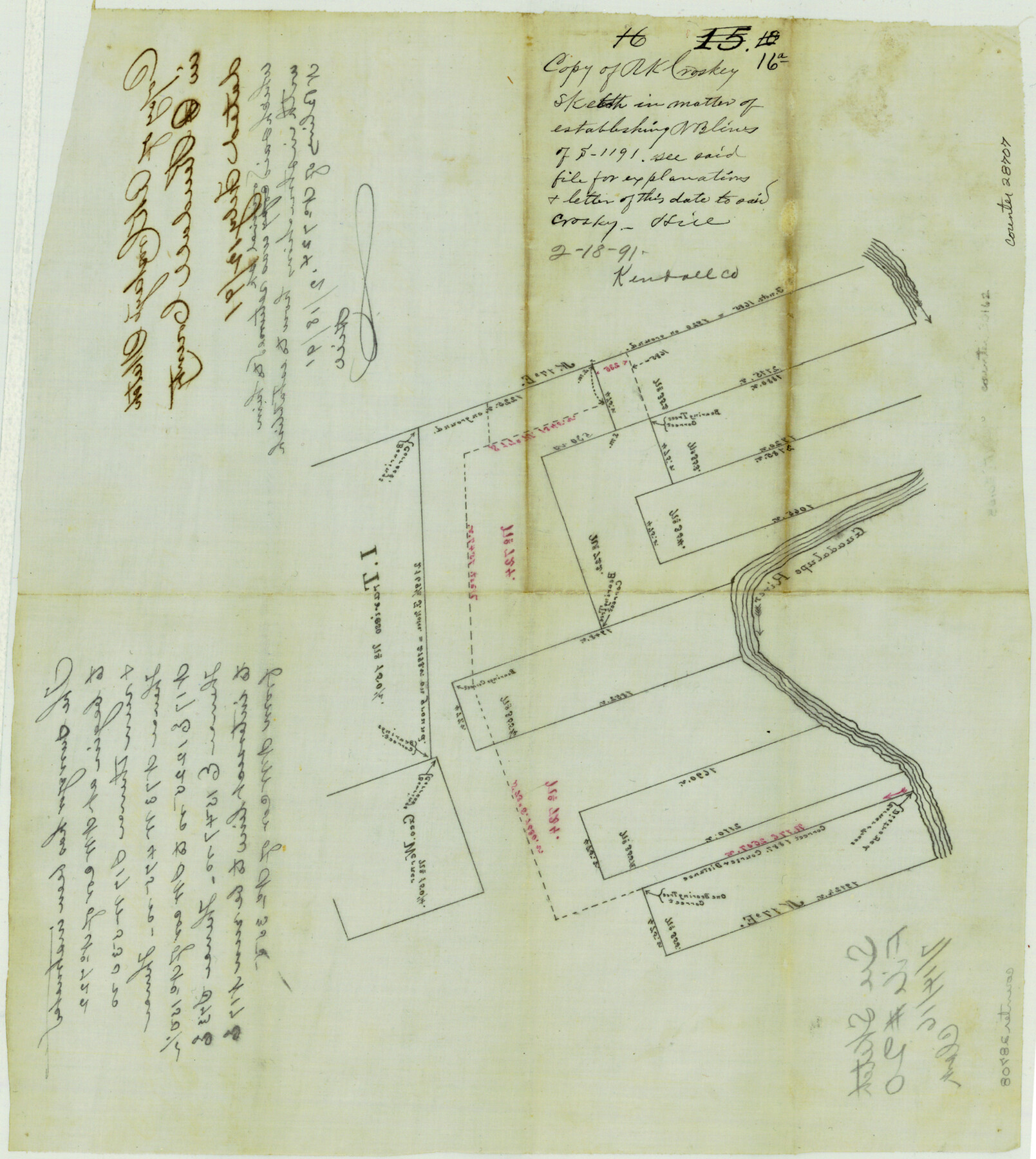
Kendall County Sketch File 16a
[Copy of sketch to determine north boundary line of survey 724]
-
Map/Doc
28707
-
Collection
General Map Collection
-
Object Dates
2/18/1891 (Creation Date)
-
People and Organizations
R.K. Croskey (Surveyor/Engineer)
-
Counties
Kendall
-
Subjects
Surveying Sketch File
-
Height x Width
15.3 x 13.7 inches
38.9 x 34.8 cm
-
Medium
paper, manuscript
-
Features
Guadalupe River
Part of: General Map Collection
Angelina County Sketch File 13

Print $4.00
- Digital $50.00
Angelina County Sketch File 13
1860
Size 13.0 x 8.2 inches
Map/Doc 12957
Flight Mission No. BQR-9K, Frame 5, Brazoria County

Print $20.00
- Digital $50.00
Flight Mission No. BQR-9K, Frame 5, Brazoria County
1952
Size 18.7 x 22.3 inches
Map/Doc 84034
Map showing connection of land-lines with M. & P. E. Ry. through Uvalde Co.

Print $40.00
- Digital $50.00
Map showing connection of land-lines with M. & P. E. Ry. through Uvalde Co.
1882
Size 11.8 x 86.3 inches
Map/Doc 64179
Atascosa County Working Sketch 34

Print $20.00
- Digital $50.00
Atascosa County Working Sketch 34
1958
Size 13.3 x 25.5 inches
Map/Doc 67230
Denton County Working Sketch 21

Print $20.00
- Digital $50.00
Denton County Working Sketch 21
1983
Size 37.3 x 35.8 inches
Map/Doc 68626
Refugio County Boundary File 5

Print $4.00
- Digital $50.00
Refugio County Boundary File 5
Size 11.2 x 8.6 inches
Map/Doc 58256
Loving County Working Sketch 6

Print $40.00
- Digital $50.00
Loving County Working Sketch 6
1947
Size 31.3 x 51.0 inches
Map/Doc 70638
Pecos County Rolled Sketch 22

Print $40.00
- Digital $50.00
Pecos County Rolled Sketch 22
1886
Size 73.4 x 45.2 inches
Map/Doc 93461
[Surveys along the Cibolo, Balcones and Leon Creeks]
![69728, [Surveys along the Cibolo, Balcones and Leon Creeks], General Map Collection](https://historictexasmaps.com/wmedia_w700/maps/69728-1.tif.jpg)
Print $20.00
- Digital $50.00
[Surveys along the Cibolo, Balcones and Leon Creeks]
1841
Size 14.5 x 21.0 inches
Map/Doc 69728
Wharton County Working Sketch 9

Print $3.00
- Digital $50.00
Wharton County Working Sketch 9
1982
Size 12.4 x 10.4 inches
Map/Doc 72473
Gray's Geological Map of the United States

Print $20.00
- Digital $50.00
Gray's Geological Map of the United States
1873
Size 17.6 x 28.8 inches
Map/Doc 95174
Map of Wilbarger County

Print $20.00
- Digital $50.00
Map of Wilbarger County
1874
Size 23.8 x 22.2 inches
Map/Doc 4147
You may also like
Moore County Sketch File 6

Print $16.00
- Digital $50.00
Moore County Sketch File 6
1902
Size 7.3 x 8.6 inches
Map/Doc 31939
Cottle County Working Sketch 1

Print $20.00
- Digital $50.00
Cottle County Working Sketch 1
1895
Size 27.0 x 21.7 inches
Map/Doc 68311
El Paso County Sketch File 18

Print $20.00
- Digital $50.00
El Paso County Sketch File 18
Size 19.0 x 23.8 inches
Map/Doc 11454
The Republic County of Bowie. January 28, 1841

Print $20.00
The Republic County of Bowie. January 28, 1841
2020
Size 19.5 x 21.7 inches
Map/Doc 96103
Texas, Matagorda Bay, Port O'Connor to Gallinipper Point

Print $40.00
- Digital $50.00
Texas, Matagorda Bay, Port O'Connor to Gallinipper Point
1933
Size 31.1 x 48.6 inches
Map/Doc 69985
Stonewall County Sketch File B2

Print $20.00
- Digital $50.00
Stonewall County Sketch File B2
1902
Size 25.8 x 25.0 inches
Map/Doc 12377
The Republic County of Goliad. Proposed, Late Fall 1837

Print $20.00
The Republic County of Goliad. Proposed, Late Fall 1837
2020
Size 15.1 x 21.7 inches
Map/Doc 96147
Galveston to Rio Grande

Print $20.00
- Digital $50.00
Galveston to Rio Grande
1973
Size 44.2 x 36.8 inches
Map/Doc 69956
Gregg County Sketch File 2a

Print $8.00
- Digital $50.00
Gregg County Sketch File 2a
1847
Size 10.1 x 15.9 inches
Map/Doc 24566
[Maps of surveys in Reeves & Culberson Cos]
![61129, [Maps of surveys in Reeves & Culberson Cos], General Map Collection](https://historictexasmaps.com/wmedia_w700/maps/61129.tif.jpg)
Print $20.00
- Digital $50.00
[Maps of surveys in Reeves & Culberson Cos]
1937
Size 30.7 x 25.0 inches
Map/Doc 61129
Maps of Gulf Intracoastal Waterway, Texas - Sabine River to the Rio Grande and connecting waterways including ship channels

Print $20.00
- Digital $50.00
Maps of Gulf Intracoastal Waterway, Texas - Sabine River to the Rio Grande and connecting waterways including ship channels
1966
Size 14.6 x 22.2 inches
Map/Doc 61979
Brazos River, Brazos River Sheet 4

Print $20.00
- Digital $50.00
Brazos River, Brazos River Sheet 4
1926
Size 19.4 x 32.1 inches
Map/Doc 69668