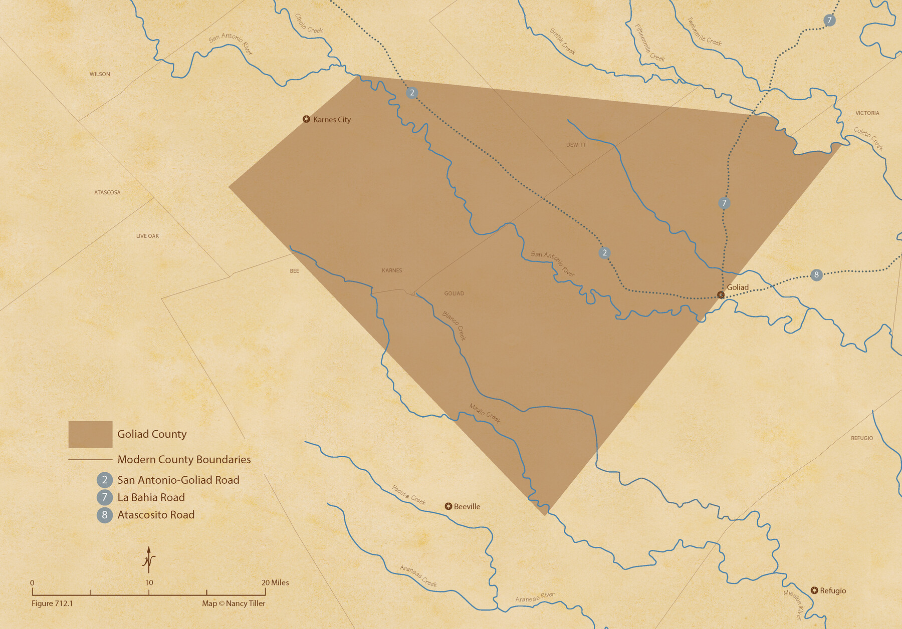
The Republic County of Goliad. Proposed, Late Fall 1837
Figure No. 712.1 from 'A Boundary Atlas of Texas, 1821-1845' by Jim Tiller
-
Map/Doc
96147
-
Collection
Nancy and Jim Tiller Digital Collection
-
Object Dates
2020/1/1 (Creation Date)
-
People and Organizations
Jim Tiller (Author)
Nancy Tiller (Cartographer)
Gang Gong (GIS Professional)
-
Counties
Goliad
-
Subjects
Atlas County Republic of Texas Texas Boundaries
-
Height x Width
15.1 x 21.7 inches
38.4 x 55.1 cm
-
Medium
digital image
-
Comments
To purchase a digital PDF copy of "A Boundary Atlas of Texas, 1821-1845" see 96437.
Part of: Nancy and Jim Tiller Digital Collection
The Republic County of Brazoria. January 1, 1838

Print $20.00
The Republic County of Brazoria. January 1, 1838
2020
Size 14.7 x 21.8 inches
Map/Doc 96111
The Republic County of Colorado. January 29, 1842

Print $20.00
The Republic County of Colorado. January 29, 1842
2020
Size 18.4 x 21.7 inches
Map/Doc 96125
Letter from Jesse Grimes Suggesting a Redefinition of the Boundary Between Harris and Montgomery Counties, April 30, 1838

Print $20.00
Letter from Jesse Grimes Suggesting a Redefinition of the Boundary Between Harris and Montgomery Counties, April 30, 1838
2020
Size 15.4 x 21.7 inches
Map/Doc 96381
The Chief Justice County of Colorado. Undated

Print $20.00
The Chief Justice County of Colorado. Undated
2020
Size 14.8 x 21.6 inches
Map/Doc 96044
The Republic County of Milam. December 29, 1845

Print $20.00
The Republic County of Milam. December 29, 1845
2020
Size 17.4 x 21.6 inches
Map/Doc 96233
The Republic County of Jasper. Boundaries Defined, December 14, 1837

Print $20.00
The Republic County of Jasper. Boundaries Defined, December 14, 1837
2020
Size 19.5 x 21.7 inches
Map/Doc 96193
The Republic County of Shelby. February 1, 1845

Print $20.00
The Republic County of Shelby. February 1, 1845
2020
Size 20.0 x 21.7 inches
Map/Doc 96287
The Republic County of Austin. Proposed, Fall 1837-May 23, 1838

Print $20.00
The Republic County of Austin. Proposed, Fall 1837-May 23, 1838
2020
Size 14.8 x 21.7 inches
Map/Doc 96081
The Republic County of San Patricio. Proposed, Late Fall 1837

Print $20.00
The Republic County of San Patricio. Proposed, Late Fall 1837
2020
Size 17.8 x 21.7 inches
Map/Doc 96273
The Republic County of Bexar. November 28, 1839

Print $20.00
The Republic County of Bexar. November 28, 1839
2020
Size 14.8 x 21.1 inches
Map/Doc 96097
The Judicial District/County of Panola. June 24, 1841

Print $20.00
The Judicial District/County of Panola. June 24, 1841
2020
Size 19.3 x 21.7 inches
Map/Doc 96341
From Citizens of Nacogdoches County to Redefine the Boundaries of Nacogdoches County, December 2, 1841

Print $20.00
From Citizens of Nacogdoches County to Redefine the Boundaries of Nacogdoches County, December 2, 1841
2020
Size 22.5 x 21.7 inches
Map/Doc 96395
You may also like
[Plat of Survey 1, Block B]
![91448, [Plat of Survey 1, Block B], Twichell Survey Records](https://historictexasmaps.com/wmedia_w700/maps/91448-1.tif.jpg)
Print $3.00
- Digital $50.00
[Plat of Survey 1, Block B]
1907
Size 11.7 x 12.6 inches
Map/Doc 91448
Refugio County Rolled Sketch 9

Print $20.00
- Digital $50.00
Refugio County Rolled Sketch 9
1955
Size 32.4 x 35.2 inches
Map/Doc 7509
Polk County Boundary File 2a

Print $40.00
- Digital $50.00
Polk County Boundary File 2a
Size 31.6 x 9.6 inches
Map/Doc 57928
Morris County Rolled Sketch 2A

Print $20.00
- Digital $50.00
Morris County Rolled Sketch 2A
Size 24.0 x 18.7 inches
Map/Doc 10286
San Augustine County Working Sketch 8

Print $20.00
- Digital $50.00
San Augustine County Working Sketch 8
1935
Size 24.8 x 35.0 inches
Map/Doc 63695
Wood County Boundary File 6

Print $32.00
- Digital $50.00
Wood County Boundary File 6
Size 14.3 x 8.6 inches
Map/Doc 60180
Oil and Gas Fields in the State of Texas

Print $40.00
Oil and Gas Fields in the State of Texas
1927
Size 58.0 x 38.0 inches
Map/Doc 76304
Right of Way & Track Map, St. Louis, Brownsville & Mexico Ry. operated by St. Louis, Brownsville & Mexico Ry. Co.

Print $40.00
- Digital $50.00
Right of Way & Track Map, St. Louis, Brownsville & Mexico Ry. operated by St. Louis, Brownsville & Mexico Ry. Co.
1919
Size 25.7 x 57.6 inches
Map/Doc 64619
Jasper County

Print $20.00
- Digital $50.00
Jasper County
1882
Size 17.6 x 14.0 inches
Map/Doc 75779
University Lands Blocks 1 to 11 Andrews-Martin-Gaines-Dawson-Winkler Counties

Print $6.00
- Digital $50.00
University Lands Blocks 1 to 11 Andrews-Martin-Gaines-Dawson-Winkler Counties
Size 30.9 x 35.3 inches
Map/Doc 62930
Jasper County Sketch File 13

Print $4.00
- Digital $50.00
Jasper County Sketch File 13
1880
Size 12.1 x 8.7 inches
Map/Doc 27804
Motley County Sketch File 31 (S)

Print $4.00
- Digital $50.00
Motley County Sketch File 31 (S)
1913
Size 14.4 x 6.7 inches
Map/Doc 32213