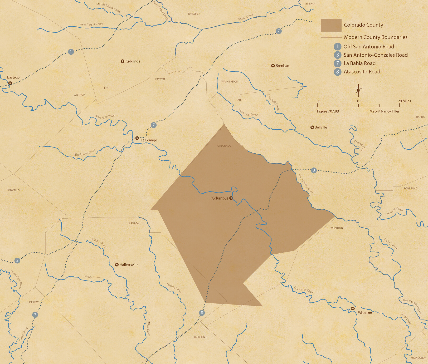
The Republic County of Colorado. January 29, 1842
Figure No. 707.8 from 'A Boundary Atlas of Texas, 1821-1845' by Jim Tiller
-
Map/Doc
96125
-
Collection
Nancy and Jim Tiller Digital Collection
-
Object Dates
2020/1/1 (Creation Date)
-
People and Organizations
Jim Tiller (Author)
Nancy Tiller (Cartographer)
Gang Gong (GIS Professional)
-
Counties
Colorado
-
Subjects
Atlas County Republic of Texas Texas Boundaries
-
Height x Width
18.4 x 21.7 inches
46.7 x 55.1 cm
-
Medium
digital image
-
Comments
To purchase a digital PDF copy of "A Boundary Atlas of Texas, 1821-1845" see 96437.
Part of: Nancy and Jim Tiller Digital Collection
The Republic County of Brazoria. December 16, 1839

Print $20.00
The Republic County of Brazoria. December 16, 1839
2020
Size 14.7 x 21.8 inches
Map/Doc 96113
The Republic County of Galveston. December 16, 1839

Print $20.00
The Republic County of Galveston. December 16, 1839
2020
Size 14.7 x 21.9 inches
Map/Doc 96144
The Republic County of Goliad. Boundaries Defined, December 2, 1841

Print $20.00
The Republic County of Goliad. Boundaries Defined, December 2, 1841
2020
Size 17.5 x 21.7 inches
Map/Doc 96151
The Republic County of Matagorda. Spring 1842

Print $20.00
The Republic County of Matagorda. Spring 1842
2020
Size 21.0 x 21.7 inches
Map/Doc 96222
The Republic County of Harris. December 29, 1845

Print $20.00
The Republic County of Harris. December 29, 1845
2020
Size 17.7 x 21.7 inches
Map/Doc 96168
The Mexican Department of Bexar. January 31, 1831

Print $20.00
The Mexican Department of Bexar. January 31, 1831
2020
Size 16.1 x 21.7 inches
Map/Doc 95968
The Republic County of Liberty. January 22, 1841

Print $20.00
The Republic County of Liberty. January 22, 1841
2020
Size 19.9 x 21.7 inches
Map/Doc 96210
The Land Offices. No. 3, Liberty, December 22, 1836

Print $20.00
The Land Offices. No. 3, Liberty, December 22, 1836
2020
Size 16.0 x 21.7 inches
Map/Doc 96416
The Republic County of Harris. Proposed, Late Fall 1837-May 15, 1838

Print $20.00
The Republic County of Harris. Proposed, Late Fall 1837-May 15, 1838
2020
Size 17.7 x 21.7 inches
Map/Doc 96162
The Republic County of Jackson. 1841

Print $20.00
The Republic County of Jackson. 1841
2020
Size 15.6 x 21.8 inches
Map/Doc 96187
The Republic County of Fayette. Spring 1842

Print $20.00
The Republic County of Fayette. Spring 1842
2020
Size 14.7 x 21.7 inches
Map/Doc 96135
The Judicial District/County of Burnet. Abolished, Spring 1842

Print $20.00
The Judicial District/County of Burnet. Abolished, Spring 1842
2020
Size 19.2 x 21.6 inches
Map/Doc 96324
You may also like
[Atlas D, Table of Contents]
![78350, [Atlas D, Table of Contents], General Map Collection](https://historictexasmaps.com/wmedia_w700/maps/78350.tif.jpg)
Print $20.00
- Digital $50.00
[Atlas D, Table of Contents]
Size 18.3 x 9.5 inches
Map/Doc 78350
General Highway Map, Navarro County, Texas

Print $20.00
General Highway Map, Navarro County, Texas
1961
Size 19.3 x 25.0 inches
Map/Doc 79610
General Highway Map, Bandera County, Texas

Print $20.00
General Highway Map, Bandera County, Texas
1961
Size 18.3 x 25.0 inches
Map/Doc 79360
Lamb County Boundary File 1d

Print $6.00
- Digital $50.00
Lamb County Boundary File 1d
Size 10.2 x 8.2 inches
Map/Doc 56051
Matagorda County Sketch File 11

Print $6.00
- Digital $50.00
Matagorda County Sketch File 11
1885
Size 9.7 x 6.2 inches
Map/Doc 30768
Edwards County Working Sketch 102

Print $20.00
- Digital $50.00
Edwards County Working Sketch 102
1971
Size 35.0 x 25.5 inches
Map/Doc 68978
Hunt County Working Sketch 7

Print $20.00
- Digital $50.00
Hunt County Working Sketch 7
1955
Size 43.2 x 25.2 inches
Map/Doc 66354
[Blk. 1 and League 3, Morris County School Land]
![90364, [Blk. 1 and League 3, Morris County School Land], Twichell Survey Records](https://historictexasmaps.com/wmedia_w700/maps/90364-1.tif.jpg)
Print $3.00
- Digital $50.00
[Blk. 1 and League 3, Morris County School Land]
Size 12.4 x 11.4 inches
Map/Doc 90364
Map of Chocolate Bay, west portion of West Bay & vicinity, Brazoria & Galveston Counties showing subdivision for mineral development

Print $40.00
- Digital $50.00
Map of Chocolate Bay, west portion of West Bay & vicinity, Brazoria & Galveston Counties showing subdivision for mineral development
Size 42.0 x 58.1 inches
Map/Doc 65806
Cooke County Rolled Sketch 6

Print $20.00
- Digital $50.00
Cooke County Rolled Sketch 6
1981
Size 19.7 x 25.1 inches
Map/Doc 5564
Flight Mission No. DQO-2K, Frame 161, Galveston County

Print $20.00
- Digital $50.00
Flight Mission No. DQO-2K, Frame 161, Galveston County
1952
Size 18.7 x 22.4 inches
Map/Doc 85050
Morris County Rolled Sketch 2A

Print $20.00
- Digital $50.00
Morris County Rolled Sketch 2A
Size 24.0 x 18.7 inches
Map/Doc 10277