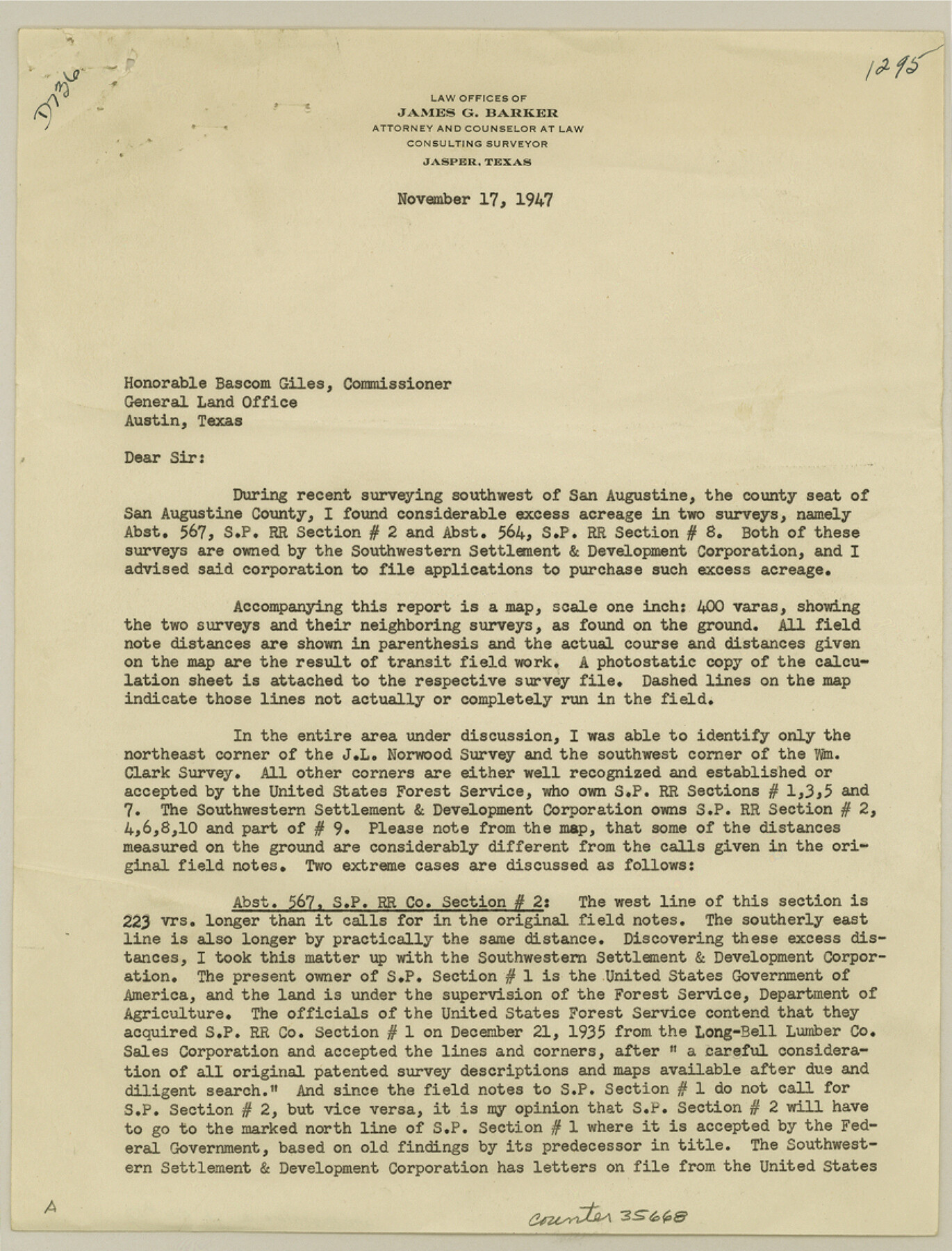
San Augustine County Sketch File 17
[Report, sketch, and correspondence regarding excess acreage in two Long-Bell Lumber Co. tracts southwest of San Augustine]
-
Map/Doc
35668
-
Collection
General Map Collection
-
Object Dates
11/17/1947 (Creation Date)
1/20/1948 (File Date)
11/25/1947 (Correspondence Date)
-
People and Organizations
James G. Barker (Surveyor/Engineer)
-
Counties
San Augustine
-
Subjects
Surveying Sketch File
-
Height x Width
11.5 x 8.7 inches
29.2 x 22.1 cm
-
Medium
multi-page, multi-format
-
Scale
1" = 20 chains
-
Features
Johnson Creek
State Highway 147
Ayish Bayou
Proposed State Highway 147
Part of: General Map Collection
Swisher County Sketch File 2b

Print $4.00
- Digital $50.00
Swisher County Sketch File 2b
1910
Size 11.2 x 8.7 inches
Map/Doc 37616
Oldham County Sketch File 1

Print $24.00
- Digital $50.00
Oldham County Sketch File 1
1880
Size 12.6 x 7.9 inches
Map/Doc 33213
Map of Comanche County

Print $20.00
- Digital $50.00
Map of Comanche County
1856
Size 22.5 x 29.8 inches
Map/Doc 3432

Culberson County Working Sketch 2

Print $20.00
- Digital $50.00
Culberson County Working Sketch 2
Size 27.7 x 18.7 inches
Map/Doc 68454
Baylor County Sketch File 10A

Print $40.00
- Digital $50.00
Baylor County Sketch File 10A
Size 19.6 x 29.0 inches
Map/Doc 10905
Orange County Sketch File 23

Print $36.00
- Digital $50.00
Orange County Sketch File 23
1911
Size 9.2 x 5.9 inches
Map/Doc 33344
San Jacinto County Working Sketch 23

Print $40.00
- Digital $50.00
San Jacinto County Working Sketch 23
1940
Size 31.5 x 53.8 inches
Map/Doc 63736
Map of Henderson County

Print $20.00
- Digital $50.00
Map of Henderson County
1871
Size 16.3 x 30.3 inches
Map/Doc 4563
Coke County Sketch File 23

Print $20.00
- Digital $50.00
Coke County Sketch File 23
Size 43.9 x 18.5 inches
Map/Doc 10338
Dimmit County Rolled Sketch 20

Print $20.00
- Digital $50.00
Dimmit County Rolled Sketch 20
1999
Size 24.6 x 36.6 inches
Map/Doc 5726
Cameron County Boundary File 2

Print $60.00
- Digital $50.00
Cameron County Boundary File 2
Size 47.8 x 22.1 inches
Map/Doc 51095
You may also like
Capitol Lands Surveyed by J. T. Munson

Print $20.00
- Digital $50.00
Capitol Lands Surveyed by J. T. Munson
Size 14.3 x 13.0 inches
Map/Doc 90511
Karnes County Working Sketch 1

Print $20.00
- Digital $50.00
Karnes County Working Sketch 1
1933
Size 19.4 x 15.3 inches
Map/Doc 66649
[C.C.S.D. & R.G.N.G. RR. Co. Blk. G east thru T.&P. Blk 33]
![89775, [C.C.S.D. & R.G.N.G. RR. Co. Blk. G east thru T.&P. Blk 33], Twichell Survey Records](https://historictexasmaps.com/wmedia_w700/maps/89775-1.tif.jpg)
Print $40.00
- Digital $50.00
[C.C.S.D. & R.G.N.G. RR. Co. Blk. G east thru T.&P. Blk 33]
1901
Size 70.2 x 23.0 inches
Map/Doc 89775
Map of Safety First Oil Company Holdings in Runnel County Texas

Print $20.00
- Digital $50.00
Map of Safety First Oil Company Holdings in Runnel County Texas
Size 17.6 x 17.4 inches
Map/Doc 91766
Howard County Rolled Sketch 10

Print $20.00
- Digital $50.00
Howard County Rolled Sketch 10
Size 19.5 x 21.3 inches
Map/Doc 6240
Hays County Working Sketch 8

Print $20.00
- Digital $50.00
Hays County Working Sketch 8
1942
Size 27.1 x 30.9 inches
Map/Doc 66082
Newton County

Print $20.00
- Digital $50.00
Newton County
1946
Size 46.8 x 40.9 inches
Map/Doc 77383

General Highway Map, Callahan County, Texas

Print $20.00
General Highway Map, Callahan County, Texas
1961
Size 25.0 x 18.2 inches
Map/Doc 79396
[Sketch showing G. C. & S.F. Block S, T. T. RR. Co. Block H1, G. & M. Block M19, Block Z3 and Block 8]
![93122, [Sketch showing G. C. & S.F. Block S, T. T. RR. Co. Block H1, G. & M. Block M19, Block Z3 and Block 8], Twichell Survey Records](https://historictexasmaps.com/wmedia_w700/maps/93122-1.tif.jpg)
Print $40.00
- Digital $50.00
[Sketch showing G. C. & S.F. Block S, T. T. RR. Co. Block H1, G. & M. Block M19, Block Z3 and Block 8]
Size 43.7 x 52.8 inches
Map/Doc 93122
Henderson County Rolled Sketch 11

Print $20.00
- Digital $50.00
Henderson County Rolled Sketch 11
1915
Size 29.4 x 42.4 inches
Map/Doc 75950
Leon County Rolled Sketch 22

Print $20.00
- Digital $50.00
Leon County Rolled Sketch 22
1983
Size 29.9 x 27.1 inches
Map/Doc 6608