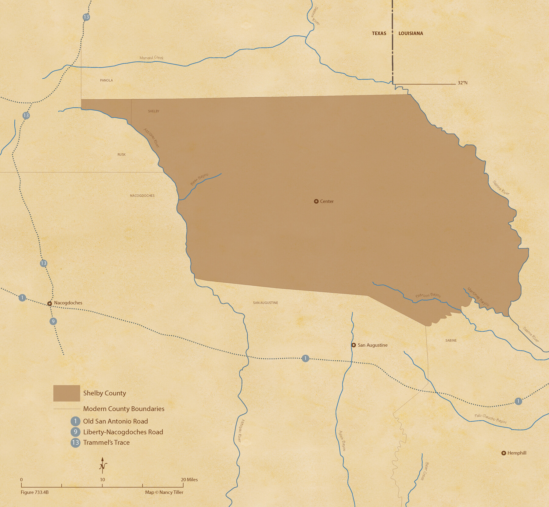
The Republic County of Shelby. February 1, 1842
Figure No. 733.4 from 'A Boundary Atlas of Texas, 1821-1845' by Jim Tiller
-
Map/Doc
96283
-
Collection
Nancy and Jim Tiller Digital Collection
-
Object Dates
2020/1/1 (Creation Date)
-
People and Organizations
Jim Tiller (Author)
Nancy Tiller (Cartographer)
Gang Gong (GIS Professional)
-
Counties
Shelby
-
Subjects
Atlas County Republic of Texas Texas Boundaries
-
Height x Width
20.0 x 21.7 inches
50.8 x 55.1 cm
-
Medium
digital image
-
Comments
To purchase a digital PDF copy of "A Boundary Atlas of Texas, 1821-1845" see 96437.
Part of: Nancy and Jim Tiller Digital Collection
The Republic County of Bowie. January 16, 1843

Print $20.00
The Republic County of Bowie. January 16, 1843
2020
Size 19.5 x 21.7 inches
Map/Doc 96106
The Republic County of Nacogdoches. Spring 1842

Print $20.00
The Republic County of Nacogdoches. Spring 1842
2020
Size 15.9 x 21.8 inches
Map/Doc 96248
The Chief Justice County of Milam. April 16, 1837

Print $20.00
The Chief Justice County of Milam. April 16, 1837
2020
Size 16.8 x 21.7 inches
Map/Doc 96059
The Republic County of Bowie. December 29, 1845

Print $20.00
The Republic County of Bowie. December 29, 1845
2020
Size 19.5 x 21.7 inches
Map/Doc 96108
The Republic County of Shelby. February 1, 1845

Print $20.00
The Republic County of Shelby. February 1, 1845
2020
Size 20.0 x 21.7 inches
Map/Doc 96287
The Republic County of Galveston. Created, May 15, 1838

Print $20.00
The Republic County of Galveston. Created, May 15, 1838
2020
Size 14.7 x 21.9 inches
Map/Doc 96143
Republic Counties. January 1, 1839

Print $20.00
Republic Counties. January 1, 1839
2020
Size 24.5 x 21.7 inches
Map/Doc 96312
The Republic County of Austin. January 28, 1841

Print $20.00
The Republic County of Austin. January 28, 1841
2020
Size 14.7 x 21.7 inches
Map/Doc 96085
The Republic County of Montgomery. February 2, 1842

Print $20.00
The Republic County of Montgomery. February 2, 1842
2020
Size 19.9 x 21.7 inches
Map/Doc 96239
From Citizens of Nacogdoches County for the Creation of a New Judicial County (Unnamed), November 16, 1840

Print $20.00
From Citizens of Nacogdoches County for the Creation of a New Judicial County (Unnamed), November 16, 1840
2020
Size 14.6 x 21.7 inches
Map/Doc 96409
The Republic County of Bexar. December 2, 1841

Print $20.00
The Republic County of Bexar. December 2, 1841
2020
Size 14.8 x 21.7 inches
Map/Doc 96098
The Chief Justice County of San Patricio. Lands in Conflict with Bexar County

Print $20.00
The Chief Justice County of San Patricio. Lands in Conflict with Bexar County
2020
Size 20.0 x 21.7 inches
Map/Doc 96073
You may also like
Travis County Sketch File 73

Print $8.00
- Digital $50.00
Travis County Sketch File 73
1848
Size 12.8 x 8.3 inches
Map/Doc 38464
Wise County Sketch File 41

Print $4.00
- Digital $50.00
Wise County Sketch File 41
1875
Size 12.8 x 8.1 inches
Map/Doc 40599
From Citizens to Redefine the Boundary Between Gonzales and Victoria Counties, April 14, 18

Print $20.00
From Citizens to Redefine the Boundary Between Gonzales and Victoria Counties, April 14, 18
2020
Size 24.9 x 21.7 inches
Map/Doc 96378
Flight Mission No. BRA-7M, Frame 82, Jefferson County

Print $20.00
- Digital $50.00
Flight Mission No. BRA-7M, Frame 82, Jefferson County
1953
Size 16.1 x 15.9 inches
Map/Doc 85504
Crockett County Rolled Sketch 37

Print $20.00
- Digital $50.00
Crockett County Rolled Sketch 37
Size 36.7 x 29.3 inches
Map/Doc 5589
Intracoastal Waterway in Texas - Corpus Christi to Point Isabel including Arroyo Colorado to Mo. Pac. R.R. Bridge Near Harlingen

Print $20.00
- Digital $50.00
Intracoastal Waterway in Texas - Corpus Christi to Point Isabel including Arroyo Colorado to Mo. Pac. R.R. Bridge Near Harlingen
1933
Size 28.2 x 40.7 inches
Map/Doc 61856
Map of Erath County

Print $20.00
- Digital $50.00
Map of Erath County
1872
Size 20.2 x 19.8 inches
Map/Doc 3521
[San Antonio del Encinal Survey and Surveys West Thereof, Brooks County, Texas]
![10773, [San Antonio del Encinal Survey and Surveys West Thereof, Brooks County, Texas], Maddox Collection](https://historictexasmaps.com/wmedia_w700/maps/10773-1.tif.jpg)
Print $20.00
- Digital $50.00
[San Antonio del Encinal Survey and Surveys West Thereof, Brooks County, Texas]
Size 18.6 x 24.6 inches
Map/Doc 10773
General Highway Map, Travis County, Texas

Print $20.00
General Highway Map, Travis County, Texas
1940
Size 18.3 x 24.9 inches
Map/Doc 79261
Flight Mission No. DIX-3P, Frame 165, Aransas County

Print $20.00
- Digital $50.00
Flight Mission No. DIX-3P, Frame 165, Aransas County
1956
Size 17.8 x 18.4 inches
Map/Doc 83771
Atascosa County Sketch File 8a

Print $4.00
- Digital $50.00
Atascosa County Sketch File 8a
Size 13.9 x 8.4 inches
Map/Doc 13761
Block 32, Township 4 North

Print $20.00
- Digital $50.00
Block 32, Township 4 North
Size 17.5 x 25.3 inches
Map/Doc 92507