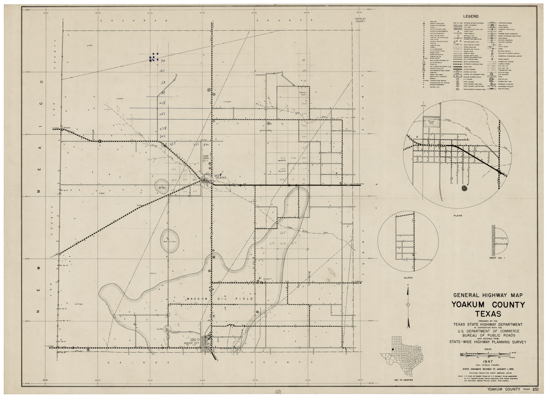
General Highway Map, Yoakum County Texas
-
Map/Doc
92815
-
Collection
Twichell Survey Records
-
Object Dates
1/1/1952 (Creation Date)
-
Counties
Yoakum
-
Subjects
County
-
Height x Width
26.3 x 19.1 inches
66.8 x 48.5 cm
Part of: Twichell Survey Records
Subdivision Map, Calhoun County School Land Leagues 1-4, Located in Hale and Floyd Counties

Print $20.00
- Digital $50.00
Subdivision Map, Calhoun County School Land Leagues 1-4, Located in Hale and Floyd Counties
Size 28.1 x 31.5 inches
Map/Doc 92660
John H. Stephens Block S2, State Capitol Leagues

Print $20.00
- Digital $50.00
John H. Stephens Block S2, State Capitol Leagues
Size 28.6 x 23.2 inches
Map/Doc 92995
Working Sketch Cochran and Yoakum Co's.

Print $40.00
- Digital $50.00
Working Sketch Cochran and Yoakum Co's.
1919
Size 54.5 x 16.4 inches
Map/Doc 89676
[Nathaniel H. Cochran Survey and Vicinity]
![91497, [Nathaniel H. Cochran Survey and Vicinity], Twichell Survey Records](https://historictexasmaps.com/wmedia_w700/maps/91497-1.tif.jpg)
Print $20.00
- Digital $50.00
[Nathaniel H. Cochran Survey and Vicinity]
Size 25.5 x 18.8 inches
Map/Doc 91497
Loving County

Print $20.00
- Digital $50.00
Loving County
1889
Size 24.6 x 19.6 inches
Map/Doc 91385
Desdemona Oil Pool

Print $20.00
- Digital $50.00
Desdemona Oil Pool
Size 38.7 x 43.1 inches
Map/Doc 89773
[Meridian thru 19th St. Muni. Standpipe]
![92864, [Meridian thru 19th St. Muni. Standpipe], Twichell Survey Records](https://historictexasmaps.com/wmedia_w700/maps/92864-1.tif.jpg)
Print $20.00
- Digital $50.00
[Meridian thru 19th St. Muni. Standpipe]
Size 23.8 x 19.5 inches
Map/Doc 92864
Section C Tech Memorial Park, Inc.

Print $2.00
- Digital $50.00
Section C Tech Memorial Park, Inc.
Size 8.1 x 10.5 inches
Map/Doc 92351
Wylie Briscoe Farm

Print $2.00
- Digital $50.00
Wylie Briscoe Farm
Size 9.2 x 15.2 inches
Map/Doc 92273
Sketch showing north boundary line of XIT lands and conflict of enclosure with L. & H. Blum land

Print $2.00
- Digital $50.00
Sketch showing north boundary line of XIT lands and conflict of enclosure with L. & H. Blum land
1906
Size 14.4 x 7.8 inches
Map/Doc 90519
J. B. Chilton's Subdivision of League 289, Gaines County, Texas

Print $20.00
- Digital $50.00
J. B. Chilton's Subdivision of League 289, Gaines County, Texas
1924
Size 18.7 x 24.7 inches
Map/Doc 92682
[Mary Fury and B. H. Epperson surveys]
![93068, [Mary Fury and B. H. Epperson surveys], Twichell Survey Records](https://historictexasmaps.com/wmedia_w700/maps/93068-1.tif.jpg)
Print $3.00
- Digital $50.00
[Mary Fury and B. H. Epperson surveys]
Size 10.8 x 15.7 inches
Map/Doc 93068
You may also like
Sutton County Sketch File 41

Print $4.00
- Digital $50.00
Sutton County Sketch File 41
1940
Size 14.4 x 8.6 inches
Map/Doc 37507
Red River County

Print $20.00
- Digital $50.00
Red River County
1896
Size 24.3 x 21.5 inches
Map/Doc 3977
Map of Coleman County

Print $20.00
- Digital $50.00
Map of Coleman County
1895
Size 26.1 x 18.9 inches
Map/Doc 3415
Flight Mission No. DAH-9M, Frame 201, Orange County

Print $20.00
- Digital $50.00
Flight Mission No. DAH-9M, Frame 201, Orange County
1953
Size 18.6 x 22.5 inches
Map/Doc 86869
[St. Louis & Southwestern]
![64275, [St. Louis & Southwestern], General Map Collection](https://historictexasmaps.com/wmedia_w700/maps/64275.tif.jpg)
Print $20.00
- Digital $50.00
[St. Louis & Southwestern]
Size 20.8 x 28.6 inches
Map/Doc 64275
Lamb-Castro County Line

Print $20.00
- Digital $50.00
Lamb-Castro County Line
Size 45.2 x 14.8 inches
Map/Doc 91059

Presidio County Texas

Print $20.00
- Digital $50.00
Presidio County Texas
Size 22.6 x 17.8 inches
Map/Doc 3967
[Town lots on Galveston Island]
![11, [Town lots on Galveston Island], General Map Collection](https://historictexasmaps.com/wmedia_w700/maps/11.tif.jpg)
Print $20.00
- Digital $50.00
[Town lots on Galveston Island]
1839
Size 18.8 x 23.0 inches
Map/Doc 11
Polk County Sketch File 7

Print $6.00
- Digital $50.00
Polk County Sketch File 7
1860
Size 12.1 x 7.9 inches
Map/Doc 34131
[Part of Blocks H. & G. N. 12, University Lands 16 and 17, C-3, C-4, A-2, 194 and Z]
![91621, [Part of Blocks H. & G. N. 12, University Lands 16 and 17, C-3, C-4, A-2, 194 and Z], Twichell Survey Records](https://historictexasmaps.com/wmedia_w700/maps/91621-1.tif.jpg)
Print $20.00
- Digital $50.00
[Part of Blocks H. & G. N. 12, University Lands 16 and 17, C-3, C-4, A-2, 194 and Z]
1907
Size 26.1 x 18.9 inches
Map/Doc 91621
Brazos Santiago, Texas

Print $20.00
- Digital $50.00
Brazos Santiago, Texas
1900
Size 18.3 x 26.7 inches
Map/Doc 73032