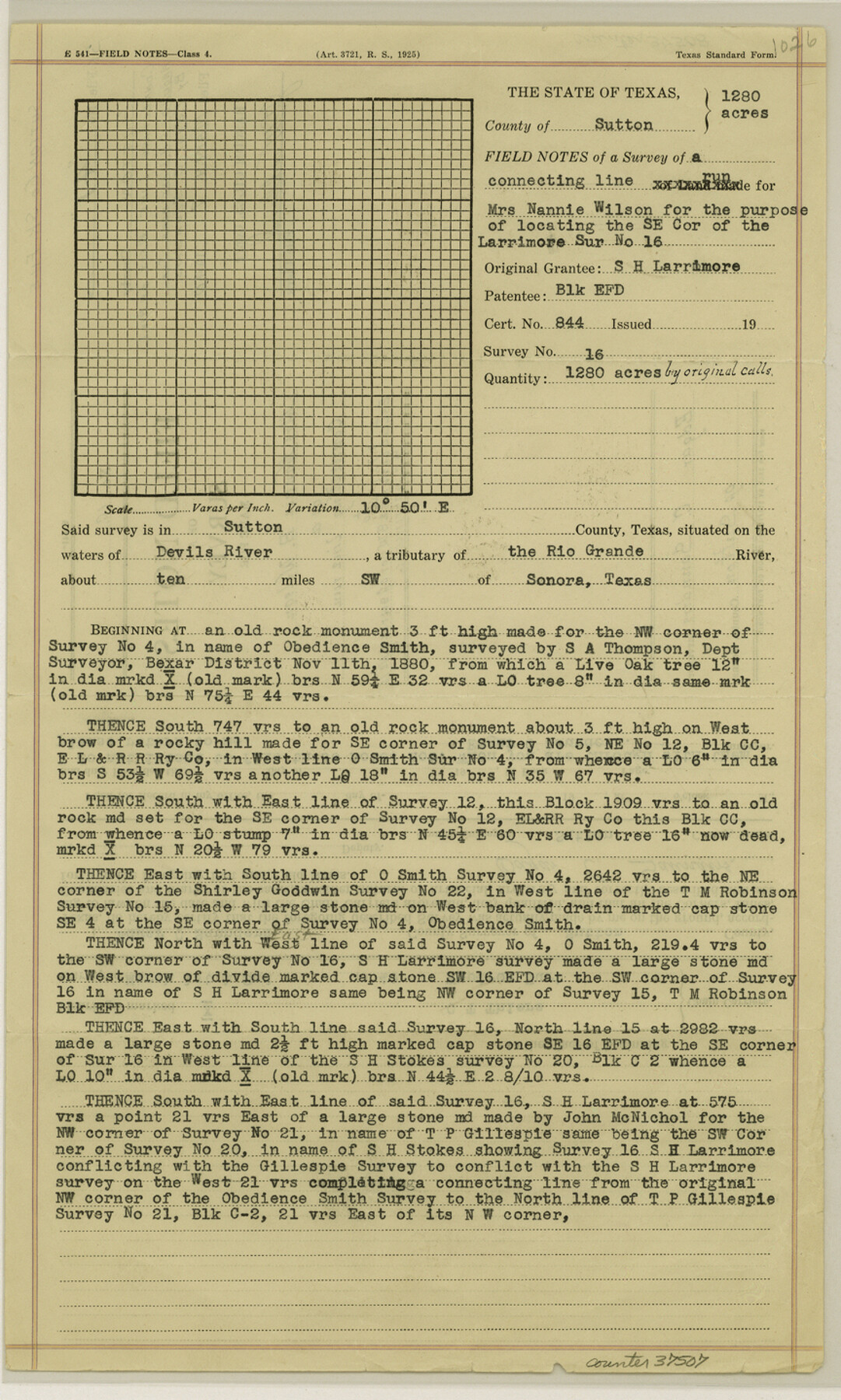
Sutton County Sketch File 41
[Connecting line west of Block C around S. H. Larrimore survey]
-
Map/Doc
37507
-
Collection
General Map Collection
-
Object Dates
1940/3/2 (Creation Date)
1940/3/7 (File Date)
1880/11/11 (Survey Date)
1940/3/2 (Survey Date)
1940/3/6 (Creation Date)
-
People and Organizations
Edgar C. Saunders (Surveyor/Engineer)
S.A. Thompson (Surveyor/Engineer)
John McNichol (Surveyor/Engineer)
C.T. Thiers (Chainman/Field Personnel)
Woodrow Hurt (Chainman/Field Personnel)
-
Counties
Sutton
-
Subjects
Surveying Sketch File
-
Height x Width
14.4 x 8.6 inches
36.6 x 21.8 cm
-
Medium
paper, print
-
Features
Devil's River
Rio Grande
Sonora
Part of: General Map Collection
Karnes County Working Sketch 13
Print $20.00
- Digital $50.00
Karnes County Working Sketch 13
1981
Size 20.2 x 16.8 inches
Map/Doc 66661


Fisher County Sketch File 21

Print $6.00
- Digital $50.00
Fisher County Sketch File 21
Size 10.3 x 17.0 inches
Map/Doc 22649
Map of Upshur County Showing Location T&P R.

Print $20.00
- Digital $50.00
Map of Upshur County Showing Location T&P R.
1872
Size 26.5 x 19.4 inches
Map/Doc 64137
Culberson County Working Sketch 34

Print $20.00
- Digital $50.00
Culberson County Working Sketch 34
1962
Size 35.2 x 26.0 inches
Map/Doc 68487
Brewster County Rolled Sketch 67

Print $20.00
- Digital $50.00
Brewster County Rolled Sketch 67
1940
Size 32.0 x 23.5 inches
Map/Doc 5233
Ward County Working Sketch Graphic Index - sheet A

Print $40.00
- Digital $50.00
Ward County Working Sketch Graphic Index - sheet A
1932
Size 30.8 x 52.8 inches
Map/Doc 76731
Bexar County Boundary File 3

Print $6.00
- Digital $50.00
Bexar County Boundary File 3
Size 8.2 x 3.6 inches
Map/Doc 50536
Flight Mission No. BRE-3P, Frame 78, Nueces County

Print $20.00
- Digital $50.00
Flight Mission No. BRE-3P, Frame 78, Nueces County
1956
Size 18.5 x 22.2 inches
Map/Doc 86819
Austin County Sketch File 10

Print $40.00
- Digital $50.00
Austin County Sketch File 10
1895
Size 25.5 x 21.0 inches
Map/Doc 10875
Cass County Sketch File 12

Print $4.00
- Digital $50.00
Cass County Sketch File 12
1851
Size 8.2 x 12.3 inches
Map/Doc 17414
You may also like
Webb County Rolled Sketch 71

Print $20.00
- Digital $50.00
Webb County Rolled Sketch 71
Size 24.2 x 18.5 inches
Map/Doc 8218
Terrell County Sketch File 33

Print $20.00
- Digital $50.00
Terrell County Sketch File 33
1924
Size 18.2 x 27.6 inches
Map/Doc 12427

Milam County Sketch File 1

Print $4.00
- Digital $50.00
Milam County Sketch File 1
1848
Size 10.7 x 7.8 inches
Map/Doc 31624
Milam County Sketch File 8

Print $20.00
- Digital $50.00
Milam County Sketch File 8
1856
Size 16.8 x 33.7 inches
Map/Doc 12091
Travis County Working Sketch Graphic Index - south part

Print $40.00
- Digital $50.00
Travis County Working Sketch Graphic Index - south part
1936
Size 42.6 x 52.8 inches
Map/Doc 76716
From Citizens of Montgomery County to Redefine the Boundary Between Harris and Montgomery Counties, May 8, 1838

Print $20.00
From Citizens of Montgomery County to Redefine the Boundary Between Harris and Montgomery Counties, May 8, 1838
2020
Size 15.4 x 21.7 inches
Map/Doc 96382
Hardin County

Print $20.00
- Digital $50.00
Hardin County
1940
Size 40.7 x 37.7 inches
Map/Doc 77303
Map of the County of Cameron

Print $40.00
- Digital $50.00
Map of the County of Cameron
1884
Size 59.4 x 35.8 inches
Map/Doc 76058
J. R. Jameson Farm

Print $2.00
- Digital $50.00
J. R. Jameson Farm
Size 9.1 x 13.9 inches
Map/Doc 92327
Map of Freestone County

Print $20.00
- Digital $50.00
Map of Freestone County
1888
Size 27.0 x 22.3 inches
Map/Doc 3561
Upton County Rolled Sketch 24

Print $20.00
- Digital $50.00
Upton County Rolled Sketch 24
1886
Size 17.3 x 43.5 inches
Map/Doc 10043