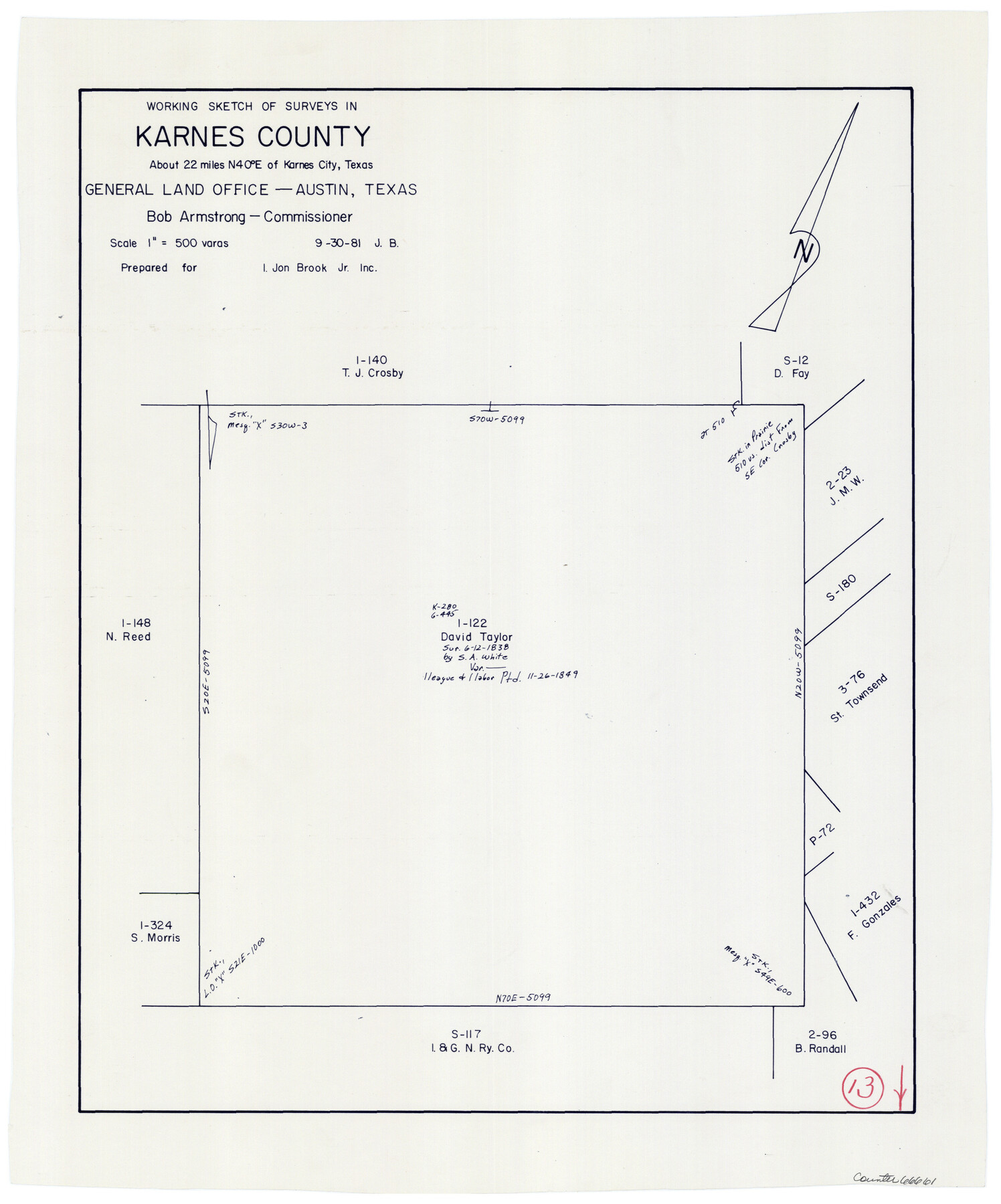
Karnes County Working Sketch 13
-
Map/Doc
66661
-
Collection
General Map Collection
-
Object Dates
9/30/1981 (Creation Date)
-
People and Organizations
Jana Brod (Draftsman)
-
Counties
Karnes
-
Subjects
Surveying Working Sketch
-
Height x Width
20.2 x 16.8 inches
51.3 x 42.7 cm
-
Scale
1" = 500 varas
Part of: General Map Collection
San Patricio County Rolled Sketch 38A

Print $20.00
- Digital $50.00
San Patricio County Rolled Sketch 38A
1958
Size 26.6 x 23.5 inches
Map/Doc 7589
Blanco County Rolled Sketch 5

Print $20.00
- Digital $50.00
Blanco County Rolled Sketch 5
Size 15.6 x 17.0 inches
Map/Doc 5143
Calhoun County Working Sketch 2b

Print $20.00
- Digital $50.00
Calhoun County Working Sketch 2b
1913
Size 17.3 x 15.8 inches
Map/Doc 67818
Flight Mission No. DCL-7C, Frame 44, Kenedy County

Print $20.00
- Digital $50.00
Flight Mission No. DCL-7C, Frame 44, Kenedy County
1943
Size 15.4 x 15.2 inches
Map/Doc 86032
Crockett County Rolled Sketch 48

Print $20.00
- Digital $50.00
Crockett County Rolled Sketch 48
1939
Size 30.0 x 40.3 inches
Map/Doc 8712
Taylor County Sketch File 8

Print $16.00
- Digital $50.00
Taylor County Sketch File 8
1879
Size 13.9 x 8.7 inches
Map/Doc 37784

Sterling County Rolled Sketch 10

Print $20.00
- Digital $50.00
Sterling County Rolled Sketch 10
1939
Size 24.2 x 31.2 inches
Map/Doc 7846
Atascosa County Sketch File 10

Print $4.00
- Digital $50.00
Atascosa County Sketch File 10
Size 12.1 x 7.7 inches
Map/Doc 13765
Concho County Sketch File 33

Print $20.00
- Digital $50.00
Concho County Sketch File 33
1926
Size 13.4 x 18.1 inches
Map/Doc 11158
Marion County Working Sketch 12

Print $20.00
- Digital $50.00
Marion County Working Sketch 12
1952
Size 24.5 x 34.2 inches
Map/Doc 70787
Menard County Working Sketch 7

Print $20.00
- Digital $50.00
Menard County Working Sketch 7
1926
Size 25.6 x 41.2 inches
Map/Doc 70954
You may also like
Flight Mission No. DIX-10P, Frame 145, Aransas County

Print $20.00
- Digital $50.00
Flight Mission No. DIX-10P, Frame 145, Aransas County
1956
Size 18.7 x 22.3 inches
Map/Doc 83947
Zavala County Working Sketch 29

Print $20.00
- Digital $50.00
Zavala County Working Sketch 29
1994
Size 33.1 x 42.9 inches
Map/Doc 62104
Hays County Sketch File 29

Print $20.00
- Digital $50.00
Hays County Sketch File 29
1938
Size 21.3 x 31.7 inches
Map/Doc 11751
San Augustine County Texas

Print $20.00
- Digital $50.00
San Augustine County Texas
1879
Size 23.8 x 16.9 inches
Map/Doc 4623
Flight Mission No. CRC-4R, Frame 148, Chambers County

Print $20.00
- Digital $50.00
Flight Mission No. CRC-4R, Frame 148, Chambers County
1956
Size 18.7 x 22.4 inches
Map/Doc 84911

Flight Mission No. DQO-7K, Frame 98, Galveston County

Print $20.00
- Digital $50.00
Flight Mission No. DQO-7K, Frame 98, Galveston County
1952
Size 18.8 x 22.4 inches
Map/Doc 85113
Wilson County Working Sketch 11

Print $20.00
- Digital $50.00
Wilson County Working Sketch 11
1980
Size 14.4 x 13.1 inches
Map/Doc 72591
The Republic County of Milam. November 28, 1839

Print $20.00
The Republic County of Milam. November 28, 1839
2020
Size 17.4 x 21.6 inches
Map/Doc 96228
Ector County Sketch File 13

Print $16.00
- Digital $50.00
Ector County Sketch File 13
1988
Size 11.5 x 9.0 inches
Map/Doc 21651
Presidio County Working Sketch 141

Print $20.00
- Digital $50.00
Presidio County Working Sketch 141
1990
Size 27.3 x 19.2 inches
Map/Doc 71819
Presidio County Rolled Sketch 2

Print $20.00
- Digital $50.00
Presidio County Rolled Sketch 2
Size 30.2 x 18.6 inches
Map/Doc 7326