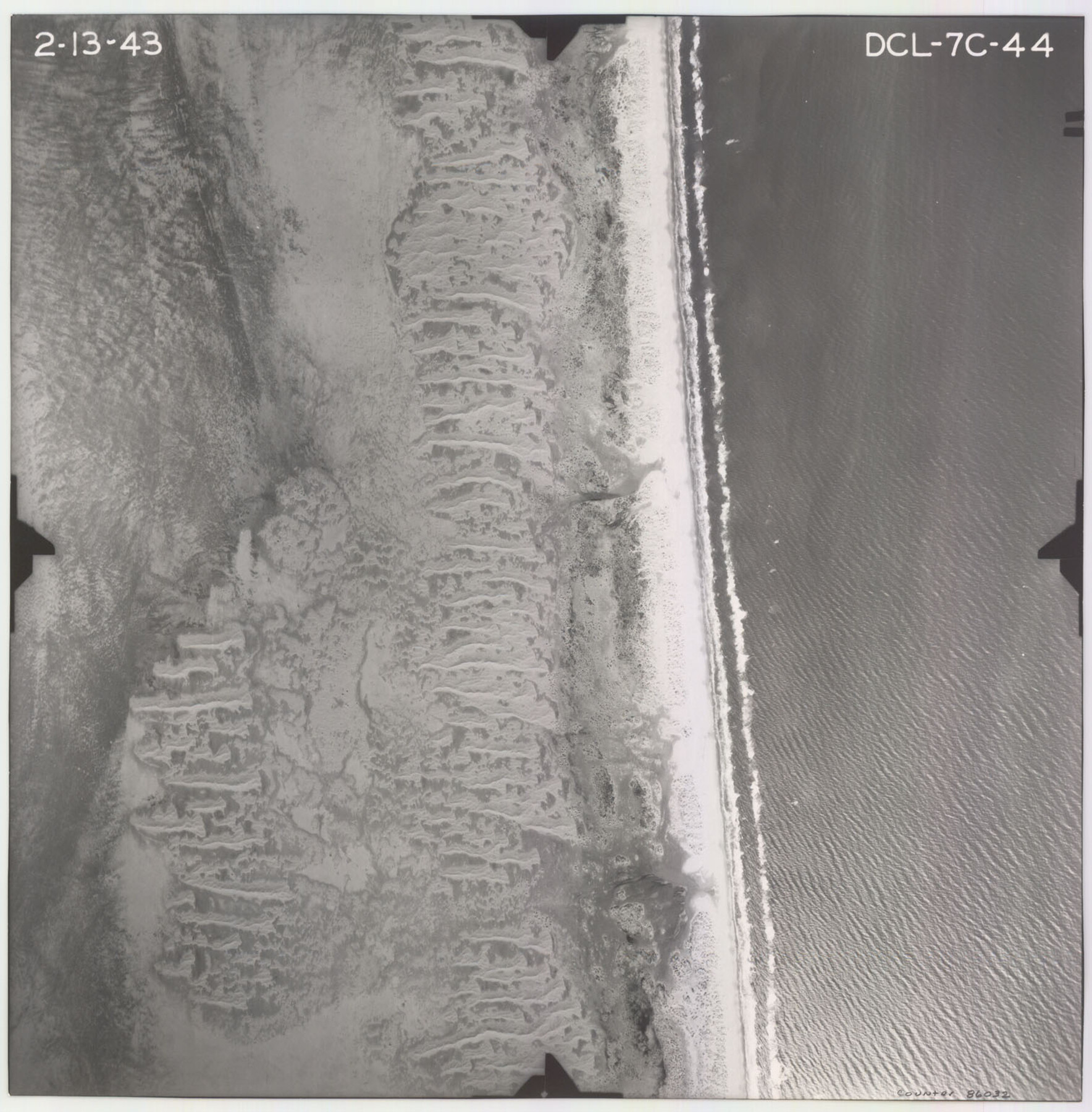
Flight Mission No. DCL-7C, Frame 44, Kenedy County
DCL-7C-44
-
Map/Doc
86032
-
Collection
General Map Collection
-
Object Dates
1943/2/13 (Creation Date)
-
People and Organizations
U. S. Department of Agriculture (Publisher)
-
Counties
Kenedy
-
Subjects
Aerial Photograph
-
Height x Width
15.4 x 15.2 inches
39.1 x 38.6 cm
-
Comments
Flown by Aerial Surveys of Pittsburgh, Inc. of Pittsburgh, Pennsylvania.
Part of: General Map Collection
Coryell County Sketch File 1

Print $13.00
- Digital $50.00
Coryell County Sketch File 1
1852
Size 15.9 x 11.0 inches
Map/Doc 19334
G. C. & S. F. Ry. Northern-Division, Alignment and Right of Way Map, Weatherford Branch, Johnson and Hood Counties, Texas

Print $40.00
- Digital $50.00
G. C. & S. F. Ry. Northern-Division, Alignment and Right of Way Map, Weatherford Branch, Johnson and Hood Counties, Texas
1935
Size 37.8 x 100.5 inches
Map/Doc 64649
Orange County Working Sketch 27

Print $20.00
- Digital $50.00
Orange County Working Sketch 27
1953
Size 31.0 x 22.9 inches
Map/Doc 71359
Map of the United States and Territories to accompany annual report of Hon. N.C. McFarland, Commissioner, General Land Office for fiscal year which ended June 30, 1884

Print $20.00
- Digital $50.00
Map of the United States and Territories to accompany annual report of Hon. N.C. McFarland, Commissioner, General Land Office for fiscal year which ended June 30, 1884
1884
Size 27.0 x 39.3 inches
Map/Doc 96631
Val Verde County Sketch File 19a

Print $42.00
- Digital $50.00
Val Verde County Sketch File 19a
Size 29.4 x 15.1 inches
Map/Doc 12568
Robertson County Working Sketch 10

Print $20.00
- Digital $50.00
Robertson County Working Sketch 10
1984
Size 20.1 x 21.6 inches
Map/Doc 63583
Concho County Working Sketch 8

Print $20.00
- Digital $50.00
Concho County Working Sketch 8
1948
Size 47.0 x 42.6 inches
Map/Doc 68190
Milam County Rolled Sketch 3A

Print $40.00
- Digital $50.00
Milam County Rolled Sketch 3A
1967
Size 49.1 x 38.8 inches
Map/Doc 43048

[Sketch of surveys in the Bexar District along the Pedernales River]
![103, [Sketch of surveys in the Bexar District along the Pedernales River], General Map Collection](https://historictexasmaps.com/wmedia_w700/maps/103-1.tif.jpg)
Print $2.00
- Digital $50.00
[Sketch of surveys in the Bexar District along the Pedernales River]
1847
Size 13.6 x 8.3 inches
Map/Doc 103
Limestone County Working Sketch 27

Print $20.00
- Digital $50.00
Limestone County Working Sketch 27
2008
Size 34.4 x 35.6 inches
Map/Doc 88767
Cass County Sketch File 16

Print $4.00
- Digital $50.00
Cass County Sketch File 16
Size 8.5 x 12.8 inches
Map/Doc 17416
You may also like
Flight Mission No. DQN-4K, Frame 4, Calhoun County

Print $20.00
- Digital $50.00
Flight Mission No. DQN-4K, Frame 4, Calhoun County
1953
Size 18.8 x 22.3 inches
Map/Doc 84369
Galveston County NRC Article 33.136 Sketch 38

Print $28.00
- Digital $50.00
Galveston County NRC Article 33.136 Sketch 38
2006
Size 24.4 x 18.6 inches
Map/Doc 83079
Flight Mission No. BRE-1P, Frame 53, Nueces County

Print $20.00
- Digital $50.00
Flight Mission No. BRE-1P, Frame 53, Nueces County
1956
Size 18.5 x 22.4 inches
Map/Doc 86642
Sterling County Sketch File 19

Print $8.00
- Digital $50.00
Sterling County Sketch File 19
1949
Size 11.2 x 8.6 inches
Map/Doc 37169
Rockwall County Sketch File 2

Print $6.00
Rockwall County Sketch File 2
Size 17.3 x 11.2 inches
Map/Doc 35415

Bell County Working Sketch 10

Print $20.00
- Digital $50.00
Bell County Working Sketch 10
1954
Size 38.2 x 41.4 inches
Map/Doc 67350
Hardeman County Sketch File 3

Print $8.00
- Digital $50.00
Hardeman County Sketch File 3
1880
Size 14.2 x 8.8 inches
Map/Doc 24987
Runnels County Sketch File E

Print $6.00
Runnels County Sketch File E
1895
Size 12.7 x 8.3 inches
Map/Doc 35481
Flight Mission No. CRC-4R, Frame 78, Chambers County

Print $20.00
- Digital $50.00
Flight Mission No. CRC-4R, Frame 78, Chambers County
1956
Size 18.7 x 22.5 inches
Map/Doc 84882
Upton County Rolled Sketch 28

Print $20.00
- Digital $50.00
Upton County Rolled Sketch 28
Size 19.6 x 27.5 inches
Map/Doc 8075
Coleman County Sketch File 44

Print $17.00
- Digital $50.00
Coleman County Sketch File 44
Size 14.1 x 8.6 inches
Map/Doc 18783