Kenedy County Rolled Sketch 4

Print $40.00
- Digital $50.00
Kenedy County Rolled Sketch 4
1904
Size: 39.4 x 57.6 inches
10654
Kenedy County Rolled Sketch 16

Print $40.00
- Digital $50.00
Kenedy County Rolled Sketch 16
1978
Size: 36.7 x 50.2 inches
10693
Kenedy County Rolled Sketch 17

Print $40.00
- Digital $50.00
Kenedy County Rolled Sketch 17
1958
Size: 96.6 x 28.5 inches
10726
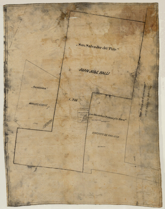
[Sketch of 'San Salvador del Tule', Juan Jose Balli Grant, Hidalgo County, Texas]
Print $20.00
- Digital $50.00
[Sketch of 'San Salvador del Tule', Juan Jose Balli Grant, Hidalgo County, Texas]
Size: 22.0 x 17.5 inches
10756
San Antonio del Encinal as Corrected

Print $20.00
- Digital $50.00
San Antonio del Encinal as Corrected
1916
Size: 31.2 x 31.5 inches
10757
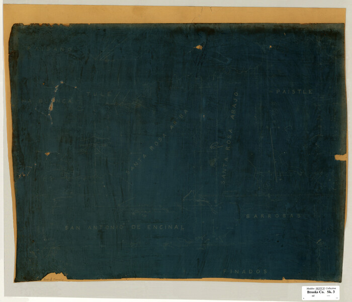
[Santa Rosa Leagues, Brooks & Kenedy Counties, Texas]
Print $20.00
- Digital $50.00
[Santa Rosa Leagues, Brooks & Kenedy Counties, Texas]
Size: 21.0 x 24.6 inches
10774
Brooks County Sketch File 8

Print $40.00
- Digital $50.00
Brooks County Sketch File 8
1946
Size: 26.5 x 38.4 inches
11018
Brooks County Sketch File 7

Print $10.00
- Digital $50.00
Brooks County Sketch File 7
1946
Size: 11.3 x 8.6 inches
16566
Baffin and Alazan Bays, Cayo Infiernillo in Kenedy and Kleberg Counties, showing Subdivision for Mineral Development

Print $40.00
- Digital $50.00
Baffin and Alazan Bays, Cayo Infiernillo in Kenedy and Kleberg Counties, showing Subdivision for Mineral Development
1949
Size: 33.0 x 52.4 inches
1923
Part of Laguna Madre in Kenedy and Willacy Counties, showing Subdivision for Mineral Development

Print $40.00
- Digital $50.00
Part of Laguna Madre in Kenedy and Willacy Counties, showing Subdivision for Mineral Development
1946
Size: 49.1 x 30.0 inches
1924
Texas Gulf Coast, from the Sabine River to the Rio Grande as Subdivided for Mineral Development; Aransas, Nueces, Kleberg, Kenedy, Willacy, and Cameron Counties

Print $40.00
- Digital $50.00
Texas Gulf Coast, from the Sabine River to the Rio Grande as Subdivided for Mineral Development; Aransas, Nueces, Kleberg, Kenedy, Willacy, and Cameron Counties
1976
Size: 118.0 x 43.0 inches
1940
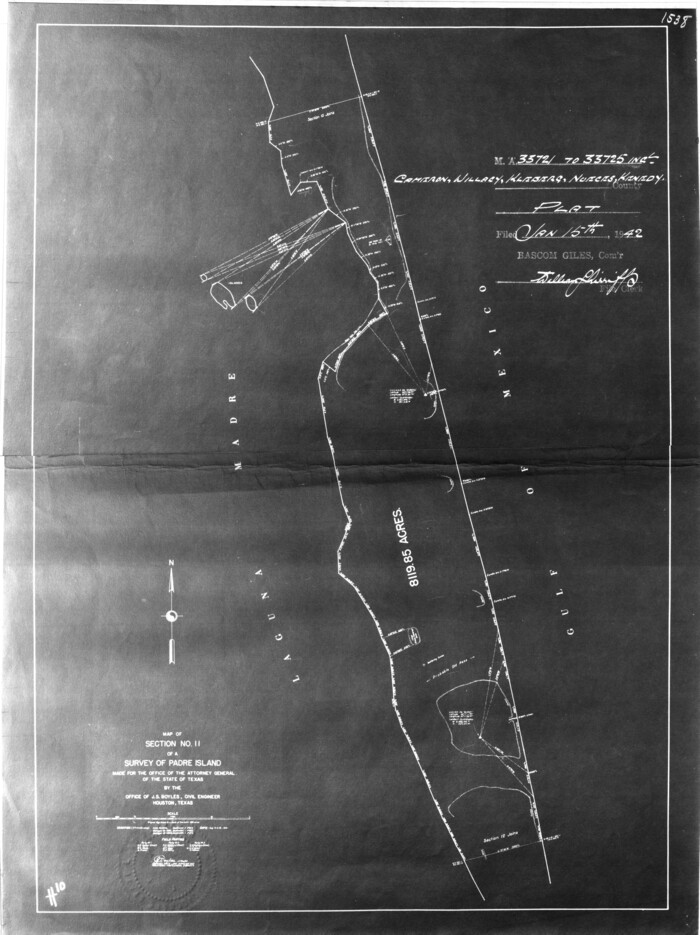
Map of section no. 4 of a survey of Padre Island made for the Office of the Attorney General of the State of Texas

Print $40.00
- Digital $50.00
Map of section no. 4 of a survey of Padre Island made for the Office of the Attorney General of the State of Texas
1941
Size: 82.6 x 40.8 inches
2260
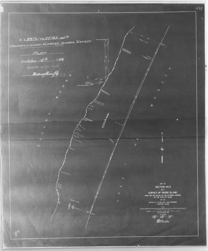
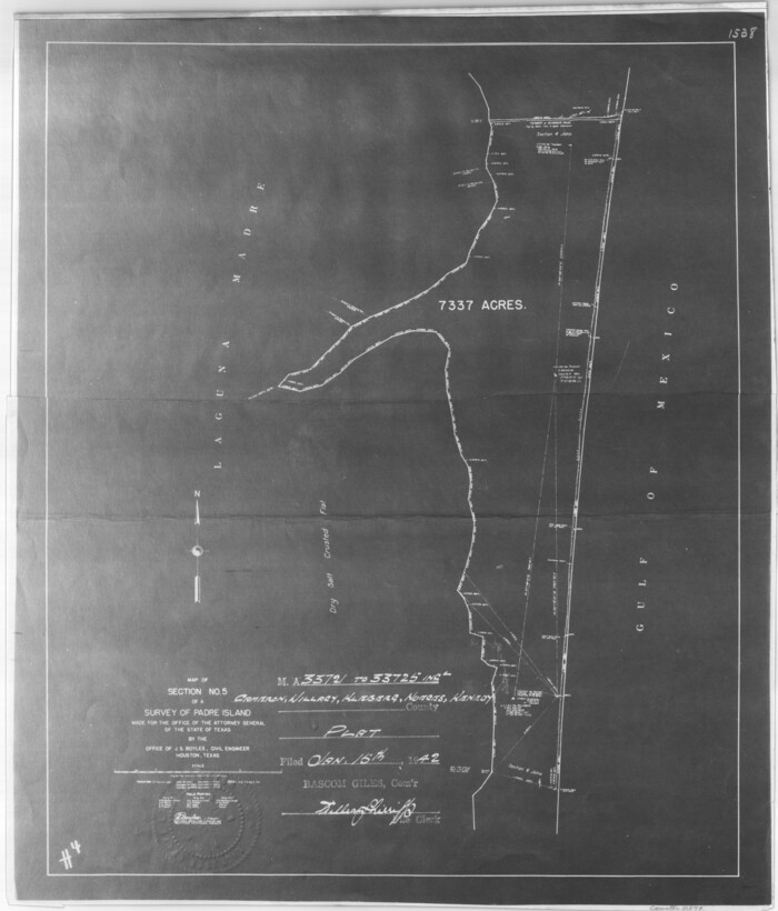
Map of section no. 5 of a survey of Padre Island made for the Office of the Attorney General of the State of Texas

Print $40.00
- Digital $50.00
Map of section no. 5 of a survey of Padre Island made for the Office of the Attorney General of the State of Texas
1941
Size: 49.8 x 40.0 inches
2261
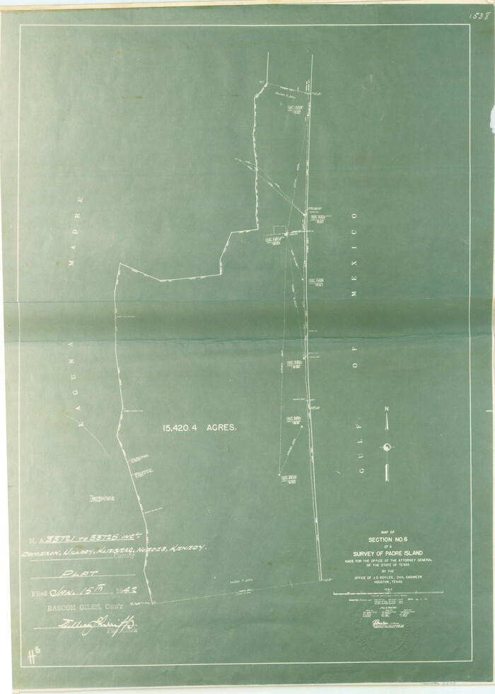
Map of section no. 6 of a survey of Padre Island made for the Office of the Attorney General of the State of Texas

Print $40.00
- Digital $50.00
Map of section no. 6 of a survey of Padre Island made for the Office of the Attorney General of the State of Texas
1941
Size: 57.9 x 40.8 inches
2262
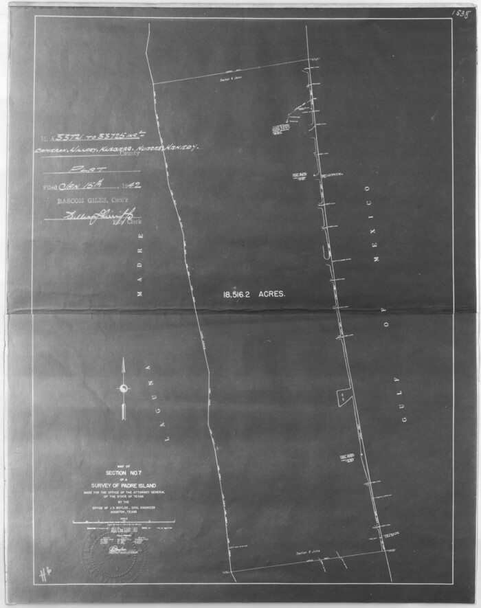
Map of section no. 7 of a survey of Padre Island made for the Office of the Attorney General of the State of Texas

Print $40.00
- Digital $50.00
Map of section no. 7 of a survey of Padre Island made for the Office of the Attorney General of the State of Texas
1941
Size: 56.3 x 41.2 inches
2263
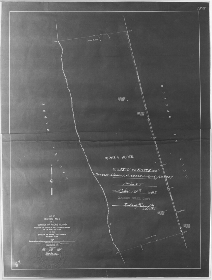
Map of section no. 8 of a survey of Padre Island made for the Office of the Attorney General of the State of Texas

Print $40.00
- Digital $50.00
Map of section no. 8 of a survey of Padre Island made for the Office of the Attorney General of the State of Texas
1941
Size: 56.2 x 40.3 inches
2264
Hidalgo County Sketch File 8

Print $4.00
- Digital $50.00
Hidalgo County Sketch File 8
1890
Size: 14.1 x 8.6 inches
26407
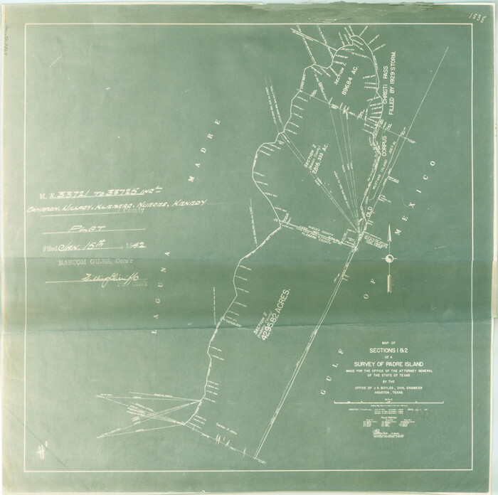
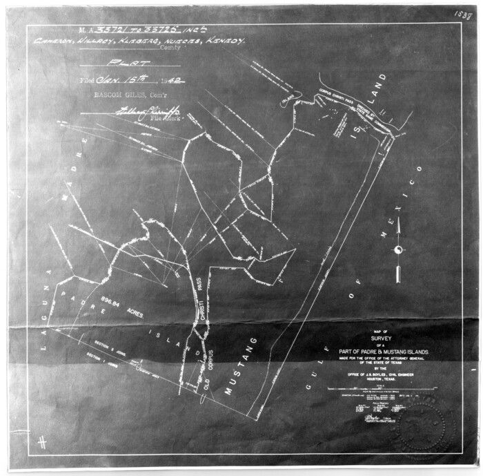
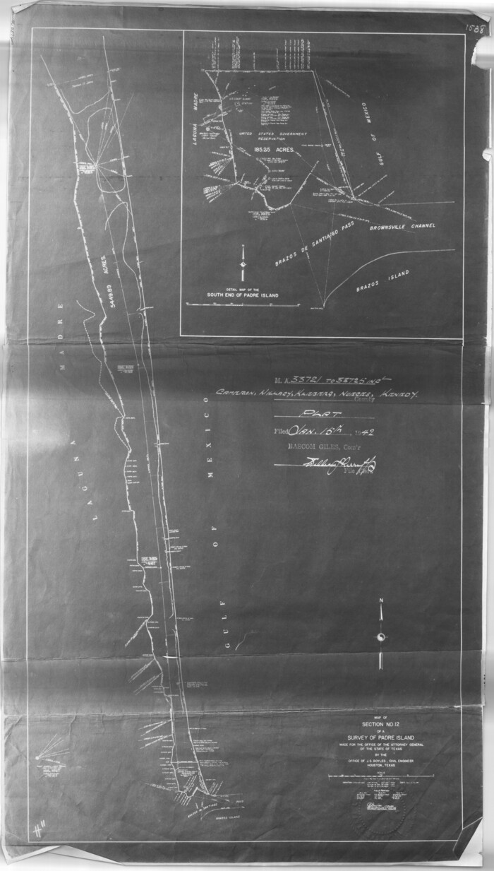
[Sketch for Mineral Application 33721 - 33725 Incl. - Padre and Mustang Island]
Print $20.00
- Digital $50.00
[Sketch for Mineral Application 33721 - 33725 Incl. - Padre and Mustang Island]
1942
Size: 29.7 x 22.3 inches
2868
[Sketch for Mineral Application 33721 - 33725 Incl. - Padre and Mustang Island]
Print $20.00
- Digital $50.00
[Sketch for Mineral Application 33721 - 33725 Incl. - Padre and Mustang Island]
1942
Size: 22.2 x 22.3 inches
2869
[Sketch for Mineral Application 33721 - 33725 Incl. - Padre and Mustang Island]
Print $20.00
- Digital $50.00
[Sketch for Mineral Application 33721 - 33725 Incl. - Padre and Mustang Island]
1942
Size: 22.1 x 22.4 inches
2870
[Sketch for Mineral Application 33721 - 33725 Incl. - Padre and Mustang Island]
Print $20.00
- Digital $50.00
[Sketch for Mineral Application 33721 - 33725 Incl. - Padre and Mustang Island]
1942
Size: 27.0 x 22.4 inches
2871
[Sketch for Mineral Application 33721 - 33725 Incl. - Padre and Mustang Island]
Print $20.00
- Digital $50.00
[Sketch for Mineral Application 33721 - 33725 Incl. - Padre and Mustang Island]
1942
Size: 26.6 x 22.7 inches
2873
Kenedy County Sketch File 1

Print $68.00
- Digital $50.00
Kenedy County Sketch File 1
1950
Size: 14.2 x 8.8 inches
28739
[Sketch for Mineral Application 33721 - 33725 Incl. - Padre and Mustang Island]
Print $20.00
- Digital $50.00
[Sketch for Mineral Application 33721 - 33725 Incl. - Padre and Mustang Island]
1941
Size: 40.2 x 22.8 inches
2874
[Sketch for Mineral Application 33721 - 33725 Incl. - Padre and Mustang Island]
Print $20.00
- Digital $50.00
[Sketch for Mineral Application 33721 - 33725 Incl. - Padre and Mustang Island]
1942
Size: 30.9 x 22.0 inches
2875
[Sketch for Mineral Application 33721 - 33725 Incl. - Padre and Mustang Island]
Print $20.00
- Digital $50.00
[Sketch for Mineral Application 33721 - 33725 Incl. - Padre and Mustang Island]
1942
Size: 29.1 x 23.0 inches
2876
[Sketch for Mineral Application 33721 - 33725 Incl. - Padre and Mustang Island]
Print $20.00
- Digital $50.00
[Sketch for Mineral Application 33721 - 33725 Incl. - Padre and Mustang Island]
1942
Size: 29.8 x 22.6 inches
2877
Kenedy County Sketch File 2

Print $130.00
- Digital $50.00
Kenedy County Sketch File 2
1995
Size: 11.2 x 8.7 inches
28773
[Sketch for Mineral Application 33721 - 33725 Incl. - Padre and Mustang Island]

Print $20.00
- Digital $50.00
[Sketch for Mineral Application 33721 - 33725 Incl. - Padre and Mustang Island]
1942
Size: 29.8 x 22.7 inches
2878
Kenedy County Rolled Sketch 4
Print $40.00
- Digital $50.00
Kenedy County Rolled Sketch 4
1904
-
Size
39.4 x 57.6 inches
-
Map/Doc
10654
-
Creation Date
1904
Kenedy County Rolled Sketch 16
Print $40.00
- Digital $50.00
Kenedy County Rolled Sketch 16
1978
-
Size
36.7 x 50.2 inches
-
Map/Doc
10693
-
Creation Date
1978
Kenedy County Rolled Sketch 17
Print $40.00
- Digital $50.00
Kenedy County Rolled Sketch 17
1958
-
Size
96.6 x 28.5 inches
-
Map/Doc
10726
-
Creation Date
1958
[Sketch of 'San Salvador del Tule', Juan Jose Balli Grant, Hidalgo County, Texas]
Print $20.00
- Digital $50.00
[Sketch of 'San Salvador del Tule', Juan Jose Balli Grant, Hidalgo County, Texas]
-
Size
22.0 x 17.5 inches
-
Map/Doc
10756
San Antonio del Encinal as Corrected
Print $20.00
- Digital $50.00
San Antonio del Encinal as Corrected
1916
-
Size
31.2 x 31.5 inches
-
Map/Doc
10757
-
Creation Date
1916
[Santa Rosa Leagues, Brooks & Kenedy Counties, Texas]
Print $20.00
- Digital $50.00
[Santa Rosa Leagues, Brooks & Kenedy Counties, Texas]
-
Size
21.0 x 24.6 inches
-
Map/Doc
10774
Brooks County Sketch File 8
Print $40.00
- Digital $50.00
Brooks County Sketch File 8
1946
-
Size
26.5 x 38.4 inches
-
Map/Doc
11018
-
Creation Date
1946
Brooks County Sketch File 7
Print $10.00
- Digital $50.00
Brooks County Sketch File 7
1946
-
Size
11.3 x 8.6 inches
-
Map/Doc
16566
-
Creation Date
1946
Kenedy County

Print $20.00
- Digital $50.00
Kenedy County
1913
-
Size
40.2 x 31.1 inches
-
Map/Doc
1873
-
Creation Date
1913
Baffin and Alazan Bays, Cayo Infiernillo in Kenedy and Kleberg Counties, showing Subdivision for Mineral Development
Print $40.00
- Digital $50.00
Baffin and Alazan Bays, Cayo Infiernillo in Kenedy and Kleberg Counties, showing Subdivision for Mineral Development
1949
-
Size
33.0 x 52.4 inches
-
Map/Doc
1923
-
Creation Date
1949
Part of Laguna Madre in Kenedy and Willacy Counties, showing Subdivision for Mineral Development
Print $40.00
- Digital $50.00
Part of Laguna Madre in Kenedy and Willacy Counties, showing Subdivision for Mineral Development
1946
-
Size
49.1 x 30.0 inches
-
Map/Doc
1924
-
Creation Date
1946
Texas Gulf Coast, from the Sabine River to the Rio Grande as Subdivided for Mineral Development; Aransas, Nueces, Kleberg, Kenedy, Willacy, and Cameron Counties
Print $40.00
- Digital $50.00
Texas Gulf Coast, from the Sabine River to the Rio Grande as Subdivided for Mineral Development; Aransas, Nueces, Kleberg, Kenedy, Willacy, and Cameron Counties
1976
-
Size
118.0 x 43.0 inches
-
Map/Doc
1940
-
Creation Date
1976
Map of section no. 4 of a survey of Padre Island made for the Office of the Attorney General of the State of Texas
Print $40.00
- Digital $50.00
Map of section no. 4 of a survey of Padre Island made for the Office of the Attorney General of the State of Texas
1941
-
Size
82.6 x 40.8 inches
-
Map/Doc
2260
-
Creation Date
1941
Map of section no. 5 of a survey of Padre Island made for the Office of the Attorney General of the State of Texas
Print $40.00
- Digital $50.00
Map of section no. 5 of a survey of Padre Island made for the Office of the Attorney General of the State of Texas
1941
-
Size
49.8 x 40.0 inches
-
Map/Doc
2261
-
Creation Date
1941
Map of section no. 6 of a survey of Padre Island made for the Office of the Attorney General of the State of Texas
Print $40.00
- Digital $50.00
Map of section no. 6 of a survey of Padre Island made for the Office of the Attorney General of the State of Texas
1941
-
Size
57.9 x 40.8 inches
-
Map/Doc
2262
-
Creation Date
1941
Map of section no. 7 of a survey of Padre Island made for the Office of the Attorney General of the State of Texas
Print $40.00
- Digital $50.00
Map of section no. 7 of a survey of Padre Island made for the Office of the Attorney General of the State of Texas
1941
-
Size
56.3 x 41.2 inches
-
Map/Doc
2263
-
Creation Date
1941
Map of section no. 8 of a survey of Padre Island made for the Office of the Attorney General of the State of Texas
Print $40.00
- Digital $50.00
Map of section no. 8 of a survey of Padre Island made for the Office of the Attorney General of the State of Texas
1941
-
Size
56.2 x 40.3 inches
-
Map/Doc
2264
-
Creation Date
1941
Hidalgo County Sketch File 8
Print $4.00
- Digital $50.00
Hidalgo County Sketch File 8
1890
-
Size
14.1 x 8.6 inches
-
Map/Doc
26407
-
Creation Date
1890
[Sketch for Mineral Application 33721 - 33725 Incl. - Padre and Mustang Island]
Print $20.00
- Digital $50.00
[Sketch for Mineral Application 33721 - 33725 Incl. - Padre and Mustang Island]
1942
-
Size
29.7 x 22.3 inches
-
Map/Doc
2868
-
Creation Date
1942
[Sketch for Mineral Application 33721 - 33725 Incl. - Padre and Mustang Island]
Print $20.00
- Digital $50.00
[Sketch for Mineral Application 33721 - 33725 Incl. - Padre and Mustang Island]
1942
-
Size
22.2 x 22.3 inches
-
Map/Doc
2869
-
Creation Date
1942
[Sketch for Mineral Application 33721 - 33725 Incl. - Padre and Mustang Island]
Print $20.00
- Digital $50.00
[Sketch for Mineral Application 33721 - 33725 Incl. - Padre and Mustang Island]
1942
-
Size
22.1 x 22.4 inches
-
Map/Doc
2870
-
Creation Date
1942
[Sketch for Mineral Application 33721 - 33725 Incl. - Padre and Mustang Island]
Print $20.00
- Digital $50.00
[Sketch for Mineral Application 33721 - 33725 Incl. - Padre and Mustang Island]
1942
-
Size
27.0 x 22.4 inches
-
Map/Doc
2871
-
Creation Date
1942
[Sketch for Mineral Application 33721 - 33725 Incl. - Padre and Mustang Island]
Print $20.00
- Digital $50.00
[Sketch for Mineral Application 33721 - 33725 Incl. - Padre and Mustang Island]
1942
-
Size
26.6 x 22.7 inches
-
Map/Doc
2873
-
Creation Date
1942
Kenedy County Sketch File 1
Print $68.00
- Digital $50.00
Kenedy County Sketch File 1
1950
-
Size
14.2 x 8.8 inches
-
Map/Doc
28739
-
Creation Date
1950
[Sketch for Mineral Application 33721 - 33725 Incl. - Padre and Mustang Island]
Print $20.00
- Digital $50.00
[Sketch for Mineral Application 33721 - 33725 Incl. - Padre and Mustang Island]
1941
-
Size
40.2 x 22.8 inches
-
Map/Doc
2874
-
Creation Date
1941
[Sketch for Mineral Application 33721 - 33725 Incl. - Padre and Mustang Island]
Print $20.00
- Digital $50.00
[Sketch for Mineral Application 33721 - 33725 Incl. - Padre and Mustang Island]
1942
-
Size
30.9 x 22.0 inches
-
Map/Doc
2875
-
Creation Date
1942
[Sketch for Mineral Application 33721 - 33725 Incl. - Padre and Mustang Island]
Print $20.00
- Digital $50.00
[Sketch for Mineral Application 33721 - 33725 Incl. - Padre and Mustang Island]
1942
-
Size
29.1 x 23.0 inches
-
Map/Doc
2876
-
Creation Date
1942
[Sketch for Mineral Application 33721 - 33725 Incl. - Padre and Mustang Island]
Print $20.00
- Digital $50.00
[Sketch for Mineral Application 33721 - 33725 Incl. - Padre and Mustang Island]
1942
-
Size
29.8 x 22.6 inches
-
Map/Doc
2877
-
Creation Date
1942
Kenedy County Sketch File 2
Print $130.00
- Digital $50.00
Kenedy County Sketch File 2
1995
-
Size
11.2 x 8.7 inches
-
Map/Doc
28773
-
Creation Date
1995
[Sketch for Mineral Application 33721 - 33725 Incl. - Padre and Mustang Island]
Print $20.00
- Digital $50.00
[Sketch for Mineral Application 33721 - 33725 Incl. - Padre and Mustang Island]
1942
-
Size
29.8 x 22.7 inches
-
Map/Doc
2878
-
Creation Date
1942