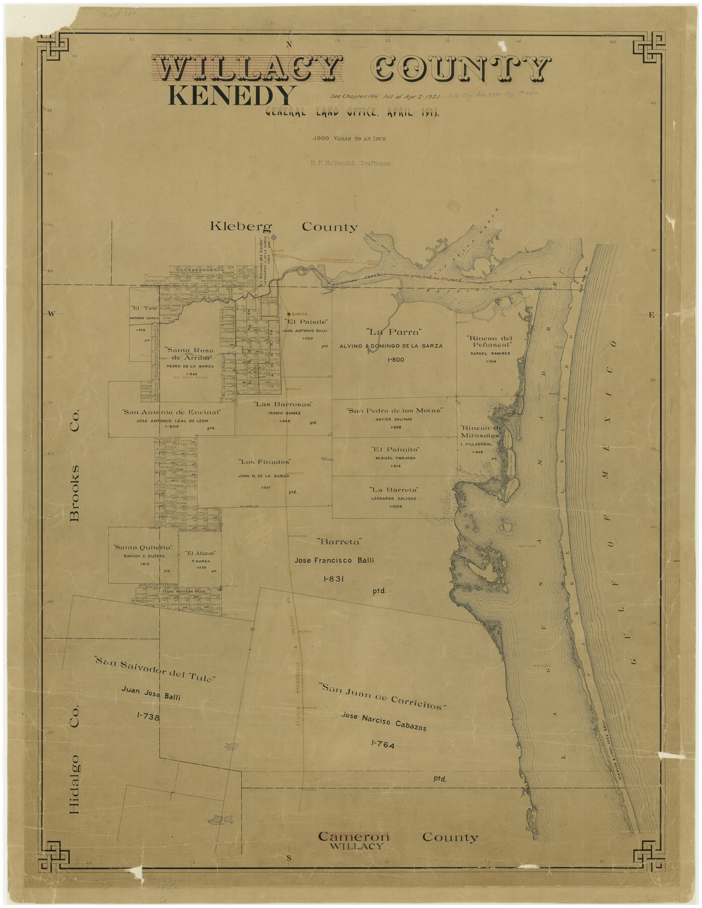
Kenedy County
-
Map/Doc
1873
-
Collection
General Map Collection
-
Object Dates
4/1913 (Creation Date)
-
People and Organizations
Texas General Land Office (Publisher)
H.F. McDonald (Compiler)
H.F. McDonald (Draftsman)
-
Counties
Kenedy
-
Subjects
County
-
Height x Width
40.2 x 31.1 inches
102.1 x 79.0 cm
-
Comments
Formerly called Willacy County.
Conservation funded in 2002 with donation from King Ranch, Incorporated. -
Features
Mesquite Lake
Potrero Cortado
Gulf of Mexico
Laguna Madre
Mud Flats
Potrero de los Cabullos [sic]
Potrero Grande
Potrero de las Canelas
Potrero Favias
Potrero Lopeña
Cuba Island
Turcotte
Katherine
Candelaria Hill
Norias
Rudolph
San Juan [Lake]
Yturria
Lago Sal Vieja
Griffins Point
Riviera
R&W
Grullo Beach
Bovido Creek
Riviera Beach
Laguna de los Olmos
Agua Dulce Creek
Baffin's Bay
Kenedy
Spohn
Penascal Rincon
Boggy Slough
Murdocks Landing
Sarita
Mifflin
Olmos Creek
SLB&M
Padre Island
Part of: General Map Collection
Medina County Rolled Sketch 23

Print $20.00
- Digital $50.00
Medina County Rolled Sketch 23
Size 30.4 x 42.6 inches
Map/Doc 89063
Padre Island National Seashore, Texas - Dependent Resurvey

Print $4.00
- Digital $50.00
Padre Island National Seashore, Texas - Dependent Resurvey
2001
Size 18.3 x 24.2 inches
Map/Doc 60546
Liberty County Working Sketch 34

Print $20.00
- Digital $50.00
Liberty County Working Sketch 34
1946
Size 26.7 x 21.2 inches
Map/Doc 70493
Uvalde County Sketch File 29

Print $8.00
- Digital $50.00
Uvalde County Sketch File 29
1873
Size 13.0 x 8.3 inches
Map/Doc 39028
Knox County Boundary File 1

Print $24.00
- Digital $50.00
Knox County Boundary File 1
Size 14.2 x 8.6 inches
Map/Doc 64998
County Map of Texas and Indian Territory

Print $20.00
- Digital $50.00
County Map of Texas and Indian Territory
1881
Size 13.1 x 9.9 inches
Map/Doc 94153
Midland County Boundary File 3

Print $4.00
- Digital $50.00
Midland County Boundary File 3
Size 8.2 x 8.3 inches
Map/Doc 57174
Red River Co.

Print $20.00
- Digital $50.00
Red River Co.
1897
Size 46.7 x 36.9 inches
Map/Doc 78402
Wichita County Rolled Sketch 18

Print $20.00
- Digital $50.00
Wichita County Rolled Sketch 18
1923
Size 25.7 x 38.0 inches
Map/Doc 8254
Flight Mission No. DAG-24K, Frame 137, Matagorda County

Print $20.00
- Digital $50.00
Flight Mission No. DAG-24K, Frame 137, Matagorda County
1953
Size 18.5 x 22.2 inches
Map/Doc 86555
Flight Mission No. CGI-3N, Frame 179, Cameron County

Print $20.00
- Digital $50.00
Flight Mission No. CGI-3N, Frame 179, Cameron County
1954
Size 18.6 x 22.2 inches
Map/Doc 84643
Navarro County Boundary File 2

Print $12.00
- Digital $50.00
Navarro County Boundary File 2
Size 8.8 x 3.9 inches
Map/Doc 57608
You may also like
Navarro County Sketch File 12

Print $4.00
- Digital $50.00
Navarro County Sketch File 12
Size 7.0 x 7.0 inches
Map/Doc 32322
[Abstract Numbering Register - Kaufman through Reagan]
![82967, [Abstract Numbering Register - Kaufman through Reagan], General Map Collection](https://historictexasmaps.com/wmedia_w700/pdf_converted_jpg/qi_pdf_thumbnail_30614.jpg)
[Abstract Numbering Register - Kaufman through Reagan]
Map/Doc 82967
[Capitol Leagues 633- 664]
![91076, [Capitol Leagues 633- 664], Twichell Survey Records](https://historictexasmaps.com/wmedia_w700/maps/91076-1.tif.jpg)
Print $20.00
- Digital $50.00
[Capitol Leagues 633- 664]
Size 17.0 x 14.6 inches
Map/Doc 91076
Brewster County Rolled Sketch 59

Print $20.00
- Digital $50.00
Brewster County Rolled Sketch 59
1938
Size 32.8 x 45.2 inches
Map/Doc 8483
Travis County Appraisal District Plat Map 2_2003

Print $20.00
- Digital $50.00
Travis County Appraisal District Plat Map 2_2003
Size 21.6 x 26.5 inches
Map/Doc 94202
Newton County Rolled Sketch 3

Print $40.00
- Digital $50.00
Newton County Rolled Sketch 3
Size 69.5 x 32.0 inches
Map/Doc 9574
Map of Hutchinson County

Print $20.00
- Digital $50.00
Map of Hutchinson County
1898
Size 41.0 x 35.4 inches
Map/Doc 16856
Angelina County Sketch File 11c

Print $7.00
- Digital $50.00
Angelina County Sketch File 11c
Size 11.1 x 6.0 inches
Map/Doc 12946
[Blk. Y2, B. & B. Blk. 5, T. T. Blk. T, North line of H. & G. N. Blk. 4]
![90140, [Blk. Y2, B. & B. Blk. 5, T. T. Blk. T, North line of H. & G. N. Blk. 4], Twichell Survey Records](https://historictexasmaps.com/wmedia_w700/maps/90140-1.tif.jpg)
Print $20.00
- Digital $50.00
[Blk. Y2, B. & B. Blk. 5, T. T. Blk. T, North line of H. & G. N. Blk. 4]
Size 18.8 x 23.7 inches
Map/Doc 90140
Presidio County Rolled Sketch 85

Print $20.00
- Digital $50.00
Presidio County Rolled Sketch 85
1930
Size 28.3 x 27.3 inches
Map/Doc 7371
Matagorda County Sketch File 24

Print $10.00
- Digital $50.00
Matagorda County Sketch File 24
1900
Size 8.2 x 5.1 inches
Map/Doc 30787
[Traverse up the Brazos and Colorado River showing distance from county site to county site]
![2054, [Traverse up the Brazos and Colorado River showing distance from county site to county site], General Map Collection](https://historictexasmaps.com/wmedia_w700/maps/2054.tif.jpg)
Print $40.00
- Digital $50.00
[Traverse up the Brazos and Colorado River showing distance from county site to county site]
1871
Size 16.2 x 98.8 inches
Map/Doc 2054