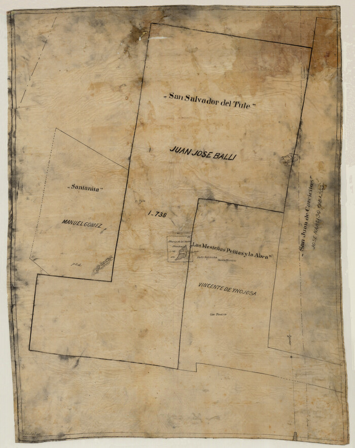
[Sketch of 'San Salvador del Tule', Juan Jose Balli Grant, Hidalgo County, Texas]
Print $20.00
- Digital $50.00
[Sketch of 'San Salvador del Tule', Juan Jose Balli Grant, Hidalgo County, Texas]
Size: 22.0 x 17.5 inches
10756
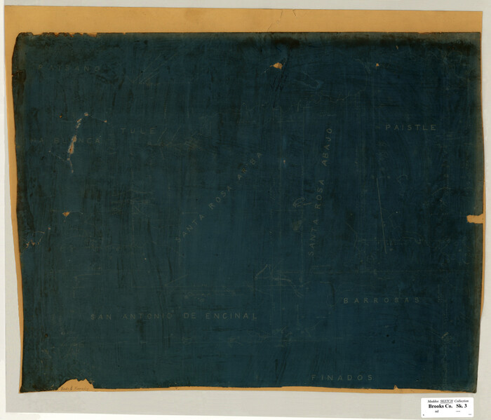
[Santa Rosa Leagues, Brooks & Kenedy Counties, Texas]
Print $20.00
- Digital $50.00
[Santa Rosa Leagues, Brooks & Kenedy Counties, Texas]
Size: 21.0 x 24.6 inches
10774
Texas Gulf Coast Map from the Sabine River to the Rio Grande as subdivided for mineral development

Print $40.00
- Digital $50.00
Texas Gulf Coast Map from the Sabine River to the Rio Grande as subdivided for mineral development
Size: 117.9 x 46.0 inches
2902
Plat of Surveys in Hidalgo Co.

Print $20.00
- Digital $50.00
Plat of Surveys in Hidalgo Co.
Size: 18.2 x 9.3 inches
405
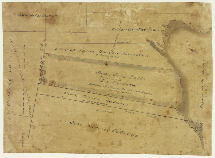
[Juan Jose Balli Survey, Kenedy County, Texas]
Print $3.00
- Digital $50.00
[Juan Jose Balli Survey, Kenedy County, Texas]
Size: 9.8 x 13.4 inches
4444
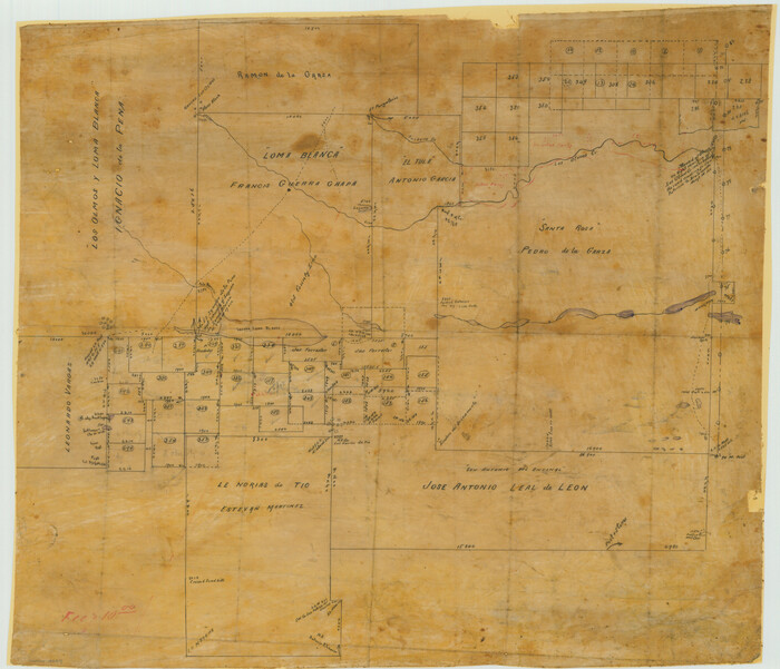
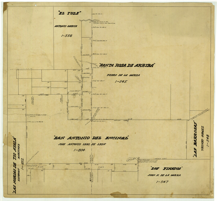
[Surveying Sketch of Loma Blanca, Santa Rosa, San Antonio del Encinal, et al]
Print $20.00
- Digital $50.00
[Surveying Sketch of Loma Blanca, Santa Rosa, San Antonio del Encinal, et al]
Size: 19.0 x 22.1 inches
4449
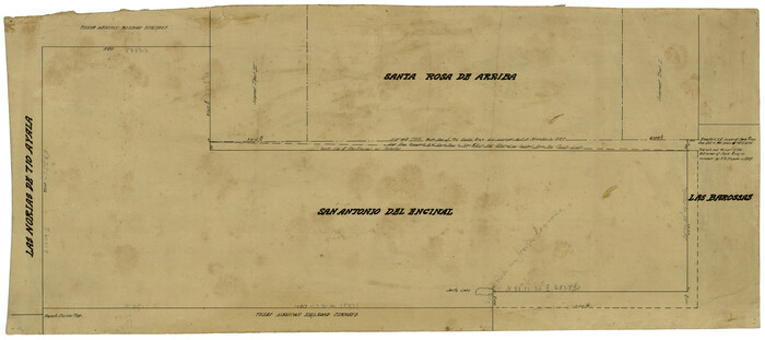
[Sketch of San Antonio del Encinal, Hidalgo County, Texas]
Print $20.00
- Digital $50.00
[Sketch of San Antonio del Encinal, Hidalgo County, Texas]
Size: 12.1 x 27.1 inches
4457
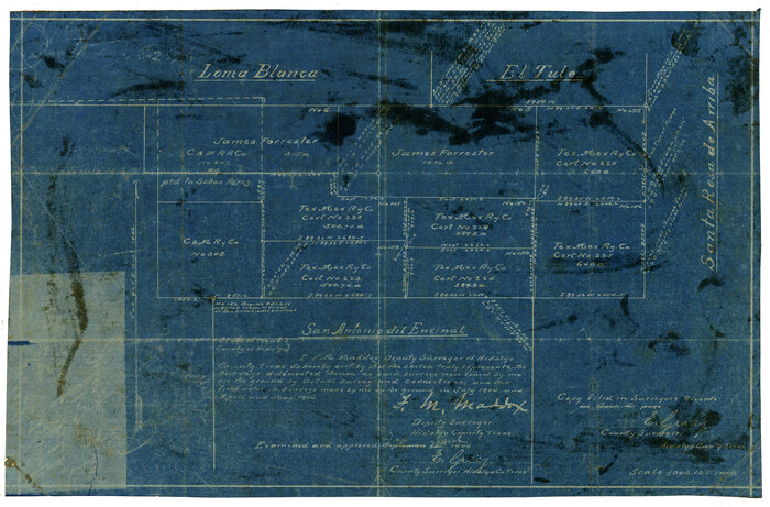
[Map of the San Antonio del Encinal as Corrected]
Print $20.00
- Digital $50.00
[Map of the San Antonio del Encinal as Corrected]
Size: 28.5 x 30.7 inches
4459
Kenedy County Boundary File 1

Print $10.00
- Digital $50.00
Kenedy County Boundary File 1
Size: 9.1 x 5.5 inches
55777
Kenedy County Boundary File 2

Print $22.00
- Digital $50.00
Kenedy County Boundary File 2
Size: 11.2 x 8.6 inches
55782
Kenedy County Boundary File 2a

Print $22.00
- Digital $50.00
Kenedy County Boundary File 2a
Size: 14.7 x 40.9 inches
55793
Padre Island National Seashore

Print $4.00
- Digital $50.00
Padre Island National Seashore
Size: 16.0 x 22.1 inches
60528
Padre Island National Seashore

Print $4.00
- Digital $50.00
Padre Island National Seashore
Size: 16.0 x 22.0 inches
60529
Padre Island National Seashore

Print $4.00
- Digital $50.00
Padre Island National Seashore
Size: 16.2 x 22.1 inches
60530
Padre Island National Seashore

Print $4.00
- Digital $50.00
Padre Island National Seashore
Size: 16.1 x 22.1 inches
60531
Padre Island National Seashore

Print $4.00
- Digital $50.00
Padre Island National Seashore
Size: 16.0 x 22.3 inches
60532
Padre Island National Seashore

Print $4.00
- Digital $50.00
Padre Island National Seashore
Size: 16.2 x 22.2 inches
60533
Padre Island National Seashore

Print $4.00
- Digital $50.00
Padre Island National Seashore
Size: 16.2 x 22.1 inches
60534
Padre Island National Seashore

Print $4.00
- Digital $50.00
Padre Island National Seashore
Size: 16.1 x 22.3 inches
60535
Padre Island National Seashore

Print $4.00
- Digital $50.00
Padre Island National Seashore
Size: 16.1 x 22.1 inches
60536
Padre Island National Seashore

Print $20.00
- Digital $50.00
Padre Island National Seashore
Size: 16.0 x 21.7 inches
60537
Padre Island National Seashore

Print $4.00
- Digital $50.00
Padre Island National Seashore
Size: 16.1 x 22.3 inches
60538
[Sketch Showing Loma Blanca , El Tule and San Antonio de Encinal Leagues in Brooks County, Texas]
Print $3.00
- Digital $50.00
[Sketch Showing Loma Blanca , El Tule and San Antonio de Encinal Leagues in Brooks County, Texas]
Size: 9.3 x 14.2 inches
624
Kenedy County Rolled Sketch 9

Print $20.00
- Digital $50.00
Kenedy County Rolled Sketch 9
Size: 27.1 x 41.7 inches
6469
Sketch for Mineral Application 33721 - 33725 Incl (Attorney General) - Map of Padre Island - Cameron, Willacy, Kleberg, Nueces and Kenedy Counties.

Print $20.00
- Digital $50.00
Sketch for Mineral Application 33721 - 33725 Incl (Attorney General) - Map of Padre Island - Cameron, Willacy, Kleberg, Nueces and Kenedy Counties.
Size: 43.3 x 23.1 inches
65663
[Sketch for Mineral Application 33721 - 33725 Incl. - Padre and Mustang Island]
Print $20.00
- Digital $50.00
[Sketch for Mineral Application 33721 - 33725 Incl. - Padre and Mustang Island]
Size: 42.3 x 22.6 inches
65664
Brooks County Working Sketch 3

Print $20.00
- Digital $50.00
Brooks County Working Sketch 3
Size: 16.2 x 21.3 inches
67787
Kenedy County Working Sketch 1

Print $20.00
- Digital $50.00
Kenedy County Working Sketch 1
Size: 31.1 x 22.0 inches
70002
Texas Intracoastal Waterway - Laguna Madre - Dagger Hill to Potrero Grande

Print $20.00
- Digital $50.00
Texas Intracoastal Waterway - Laguna Madre - Dagger Hill to Potrero Grande
Size: 39.0 x 27.3 inches
73508

[Sketch of 'San Salvador del Tule', Juan Jose Balli Grant, Hidalgo County, Texas]
Print $20.00
- Digital $50.00
[Sketch of 'San Salvador del Tule', Juan Jose Balli Grant, Hidalgo County, Texas]
-
Size
22.0 x 17.5 inches
-
Map/Doc
10756
[Santa Rosa Leagues, Brooks & Kenedy Counties, Texas]
Print $20.00
- Digital $50.00
[Santa Rosa Leagues, Brooks & Kenedy Counties, Texas]
-
Size
21.0 x 24.6 inches
-
Map/Doc
10774
Texas Gulf Coast Map from the Sabine River to the Rio Grande as subdivided for mineral development
Print $40.00
- Digital $50.00
Texas Gulf Coast Map from the Sabine River to the Rio Grande as subdivided for mineral development
-
Size
117.9 x 46.0 inches
-
Map/Doc
2902
Plat of Surveys in Hidalgo Co.
Print $20.00
- Digital $50.00
Plat of Surveys in Hidalgo Co.
-
Size
18.2 x 9.3 inches
-
Map/Doc
405
[Juan Jose Balli Survey, Kenedy County, Texas]
Print $3.00
- Digital $50.00
[Juan Jose Balli Survey, Kenedy County, Texas]
-
Size
9.8 x 13.4 inches
-
Map/Doc
4444
[Surveying Sketch of Loma Blanca, Santa Rosa, San Antonio del Encinal, et al]
Print $20.00
- Digital $50.00
[Surveying Sketch of Loma Blanca, Santa Rosa, San Antonio del Encinal, et al]
-
Size
19.0 x 22.1 inches
-
Map/Doc
4449
[Sketch of San Antonio del Encinal, Hidalgo County, Texas]
Print $20.00
- Digital $50.00
[Sketch of San Antonio del Encinal, Hidalgo County, Texas]
-
Size
12.1 x 27.1 inches
-
Map/Doc
4457
[Map of the San Antonio del Encinal as Corrected]
Print $20.00
- Digital $50.00
[Map of the San Antonio del Encinal as Corrected]
-
Size
28.5 x 30.7 inches
-
Map/Doc
4459
Kenedy County Boundary File 1
Print $10.00
- Digital $50.00
Kenedy County Boundary File 1
-
Size
9.1 x 5.5 inches
-
Map/Doc
55777
Kenedy County Boundary File 2
Print $22.00
- Digital $50.00
Kenedy County Boundary File 2
-
Size
11.2 x 8.6 inches
-
Map/Doc
55782
Kenedy County Boundary File 2a
Print $22.00
- Digital $50.00
Kenedy County Boundary File 2a
-
Size
14.7 x 40.9 inches
-
Map/Doc
55793
Padre Island National Seashore
Print $4.00
- Digital $50.00
Padre Island National Seashore
-
Size
16.0 x 22.1 inches
-
Map/Doc
60528
Padre Island National Seashore
Print $4.00
- Digital $50.00
Padre Island National Seashore
-
Size
16.0 x 22.0 inches
-
Map/Doc
60529
Padre Island National Seashore
Print $4.00
- Digital $50.00
Padre Island National Seashore
-
Size
16.2 x 22.1 inches
-
Map/Doc
60530
Padre Island National Seashore
Print $4.00
- Digital $50.00
Padre Island National Seashore
-
Size
16.1 x 22.1 inches
-
Map/Doc
60531
Padre Island National Seashore
Print $4.00
- Digital $50.00
Padre Island National Seashore
-
Size
16.0 x 22.3 inches
-
Map/Doc
60532
Padre Island National Seashore
Print $4.00
- Digital $50.00
Padre Island National Seashore
-
Size
16.2 x 22.2 inches
-
Map/Doc
60533
Padre Island National Seashore
Print $4.00
- Digital $50.00
Padre Island National Seashore
-
Size
16.2 x 22.1 inches
-
Map/Doc
60534
Padre Island National Seashore
Print $4.00
- Digital $50.00
Padre Island National Seashore
-
Size
16.1 x 22.3 inches
-
Map/Doc
60535
Padre Island National Seashore
Print $4.00
- Digital $50.00
Padre Island National Seashore
-
Size
16.1 x 22.1 inches
-
Map/Doc
60536
Padre Island National Seashore
Print $20.00
- Digital $50.00
Padre Island National Seashore
-
Size
16.0 x 21.7 inches
-
Map/Doc
60537
Padre Island National Seashore
Print $4.00
- Digital $50.00
Padre Island National Seashore
-
Size
16.1 x 22.3 inches
-
Map/Doc
60538
[Sketch Showing Loma Blanca , El Tule and San Antonio de Encinal Leagues in Brooks County, Texas]
Print $3.00
- Digital $50.00
[Sketch Showing Loma Blanca , El Tule and San Antonio de Encinal Leagues in Brooks County, Texas]
-
Size
9.3 x 14.2 inches
-
Map/Doc
624
Kenedy County Rolled Sketch 9
Print $20.00
- Digital $50.00
Kenedy County Rolled Sketch 9
-
Size
27.1 x 41.7 inches
-
Map/Doc
6469
Sketch for Mineral Application 33721 - 33725 Incl (Attorney General) - Map of Padre Island - Cameron, Willacy, Kleberg, Nueces and Kenedy Counties.
Print $20.00
- Digital $50.00
Sketch for Mineral Application 33721 - 33725 Incl (Attorney General) - Map of Padre Island - Cameron, Willacy, Kleberg, Nueces and Kenedy Counties.
-
Size
43.3 x 23.1 inches
-
Map/Doc
65663
[Sketch for Mineral Application 33721 - 33725 Incl. - Padre and Mustang Island]
Print $20.00
- Digital $50.00
[Sketch for Mineral Application 33721 - 33725 Incl. - Padre and Mustang Island]
-
Size
42.3 x 22.6 inches
-
Map/Doc
65664
Brooks County Working Sketch 3
Print $20.00
- Digital $50.00
Brooks County Working Sketch 3
-
Size
16.2 x 21.3 inches
-
Map/Doc
67787
Kenedy County Working Sketch 1
Print $20.00
- Digital $50.00
Kenedy County Working Sketch 1
-
Size
31.1 x 22.0 inches
-
Map/Doc
70002
Texas Intracoastal Waterway - Laguna Madre - Dagger Hill to Potrero Grande
Print $20.00
- Digital $50.00
Texas Intracoastal Waterway - Laguna Madre - Dagger Hill to Potrero Grande
-
Size
39.0 x 27.3 inches
-
Map/Doc
73508