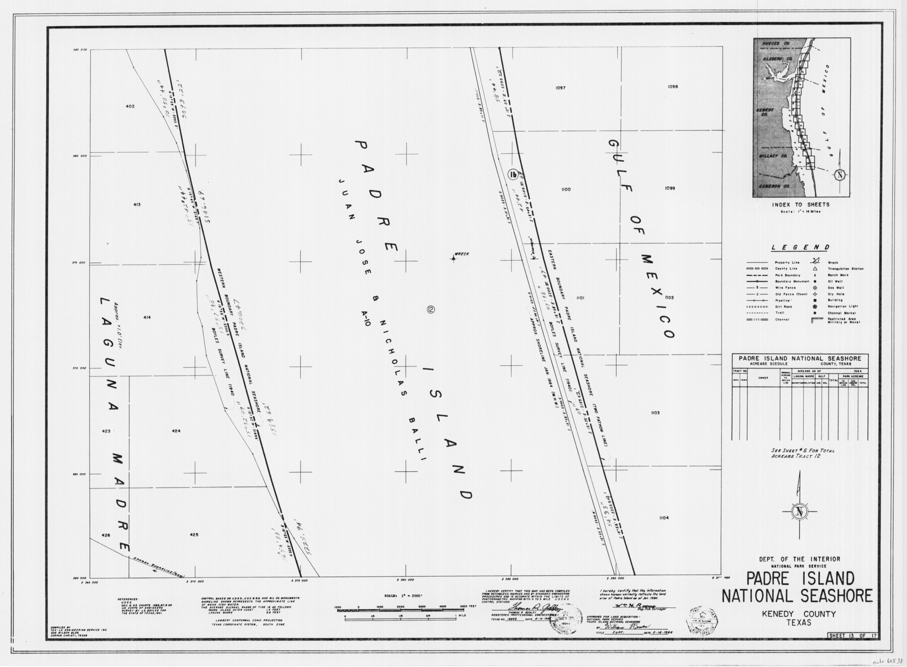
Padre Island National Seashore
17 survey plats of Padre Island National Seashore
N-2-125
-
Map/Doc
60537
-
Collection
General Map Collection
-
Counties
Kenedy
-
Height x Width
16.0 x 21.7 inches
40.6 x 55.1 cm
Part of: General Map Collection
Rusk County Rolled Sketch 8

Print $20.00
- Digital $50.00
Rusk County Rolled Sketch 8
1959
Size 22.6 x 26.3 inches
Map/Doc 7544
Webb County Sketch File 4a

Print $8.00
- Digital $50.00
Webb County Sketch File 4a
1877
Size 11.6 x 4.0 inches
Map/Doc 39718
Navigation Maps of Gulf Intracoastal Waterway, Port Arthur to Brownsville, Texas

Print $4.00
- Digital $50.00
Navigation Maps of Gulf Intracoastal Waterway, Port Arthur to Brownsville, Texas
1951
Size 16.6 x 21.5 inches
Map/Doc 65440
El Paso County Rolled Sketch WL

Print $20.00
- Digital $50.00
El Paso County Rolled Sketch WL
1922
Size 26.9 x 19.1 inches
Map/Doc 5860
Morris County Rolled Sketch 2A

Print $20.00
- Digital $50.00
Morris County Rolled Sketch 2A
Size 24.0 x 18.8 inches
Map/Doc 10226
Cass County Rolled Sketch BRR

Print $40.00
- Digital $50.00
Cass County Rolled Sketch BRR
1936
Size 67.3 x 28.0 inches
Map/Doc 8581
Bell County Sketch File 20

Print $4.00
- Digital $50.00
Bell County Sketch File 20
1855
Size 9.0 x 7.9 inches
Map/Doc 14406
Trinity County Boundary File 88

Print $42.00
- Digital $50.00
Trinity County Boundary File 88
Size 9.2 x 4.1 inches
Map/Doc 59475
Blanco County Sketch File 18

Print $4.00
- Digital $50.00
Blanco County Sketch File 18
1877
Size 12.6 x 8.5 inches
Map/Doc 14594

Culberson County Sketch File 16

Print $20.00
- Digital $50.00
Culberson County Sketch File 16
Size 27.0 x 38.1 inches
Map/Doc 11268
Johnson County Sketch File 10

Print $4.00
- Digital $50.00
Johnson County Sketch File 10
1859
Size 10.1 x 8.0 inches
Map/Doc 28443
You may also like
Upton County Sketch File 27

Print $20.00
- Digital $50.00
Upton County Sketch File 27
1928
Size 42.9 x 22.6 inches
Map/Doc 10416
General Highway Map, Marion County, Texas

Print $20.00
General Highway Map, Marion County, Texas
1961
Size 18.2 x 24.6 inches
Map/Doc 79582
Brazos River Conservation and Reclamation District Official Boundary Line Survey

Print $20.00
- Digital $50.00
Brazos River Conservation and Reclamation District Official Boundary Line Survey
1931
Size 25.1 x 36.9 inches
Map/Doc 90125
Matagorda Light to Aransas Pass

Print $20.00
- Digital $50.00
Matagorda Light to Aransas Pass
1965
Size 34.3 x 45.0 inches
Map/Doc 73398
Sutton County Rolled Sketch 35

Print $20.00
- Digital $50.00
Sutton County Rolled Sketch 35
1886
Size 30.3 x 28.4 inches
Map/Doc 7879
Bravo Ranch situated in Hartley and Oldham Counties, Texas

Print $40.00
- Digital $50.00
Bravo Ranch situated in Hartley and Oldham Counties, Texas
Size 38.8 x 51.3 inches
Map/Doc 89930
Sheet 3 copied from Champlin Book 5 [Strip Map showing T. & P. connecting lines]
![93179, Sheet 3 copied from Champlin Book 5 [Strip Map showing T. & P. connecting lines], Twichell Survey Records](https://historictexasmaps.com/wmedia_w700/maps/93179-1.tif.jpg)
Print $40.00
- Digital $50.00
Sheet 3 copied from Champlin Book 5 [Strip Map showing T. & P. connecting lines]
1909
Size 7.5 x 74.8 inches
Map/Doc 93179
Callahan County Sketch File 2

Print $8.00
- Digital $50.00
Callahan County Sketch File 2
1858
Size 11.8 x 8.7 inches
Map/Doc 35853
General Highway Map, Irion County, Texas

Print $20.00
General Highway Map, Irion County, Texas
1961
Size 18.2 x 24.5 inches
Map/Doc 79531
Cottle County Working Sketch 17

Print $20.00
- Digital $50.00
Cottle County Working Sketch 17
1975
Size 32.5 x 34.1 inches
Map/Doc 68327
Montgomery County Working Sketch 9
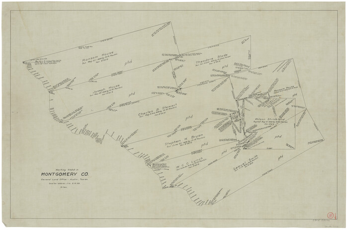
Print $20.00
- Digital $50.00
Montgomery County Working Sketch 9
1933
Size 26.4 x 39.6 inches
Map/Doc 71116
Glasscock County Rolled Sketch 8

Print $20.00
- Digital $50.00
Glasscock County Rolled Sketch 8
1951
Size 37.3 x 31.1 inches
Map/Doc 9057