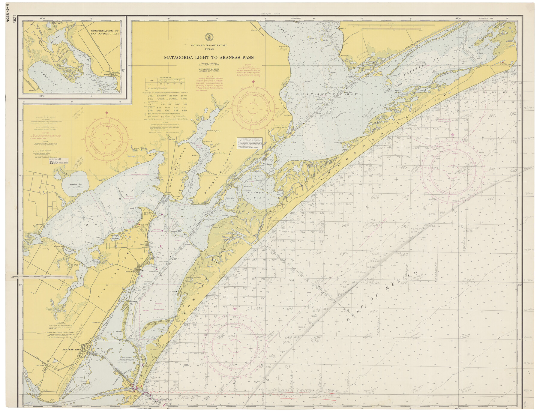
Matagorda Light to Aransas Pass
K-6-1285a
-
Map/Doc
73398
-
Collection
General Map Collection
-
Object Dates
11/8/1965 (Creation Date)
-
Counties
Refugio San Patricio Aransas
-
Subjects
Nautical Charts
-
Height x Width
34.3 x 45.0 inches
87.1 x 114.3 cm
Part of: General Map Collection
Duval County Sketch File 27

Print $6.00
- Digital $50.00
Duval County Sketch File 27
1919
Size 11.0 x 11.8 inches
Map/Doc 21334
Navigation Maps of Gulf Intracoastal Waterway, Port Arthur to Brownsville, Texas

Print $4.00
- Digital $50.00
Navigation Maps of Gulf Intracoastal Waterway, Port Arthur to Brownsville, Texas
1951
Size 16.7 x 21.3 inches
Map/Doc 65444
Jefferson County Rolled Sketch 61F

Print $20.00
- Digital $50.00
Jefferson County Rolled Sketch 61F
1928
Size 27.2 x 40.2 inches
Map/Doc 6415
Victoria County Rolled Sketch 6

Print $20.00
- Digital $50.00
Victoria County Rolled Sketch 6
Size 27.9 x 36.3 inches
Map/Doc 8152
Stonewall County Working Sketch 26

Print $20.00
- Digital $50.00
Stonewall County Working Sketch 26
1973
Size 27.0 x 17.9 inches
Map/Doc 62333
Aransas County Working Sketch 3

Print $20.00
- Digital $50.00
Aransas County Working Sketch 3
1928
Size 20.6 x 32.9 inches
Map/Doc 67170
Duval County Sketch File 41

Print $20.00
- Digital $50.00
Duval County Sketch File 41
1936
Size 19.6 x 17.2 inches
Map/Doc 11397
Coast Chart No. 211 - Padre I. and Laguna Madre, Lat. 27° 12' to Lat. 26° 33', Texas

Print $20.00
- Digital $50.00
Coast Chart No. 211 - Padre I. and Laguna Madre, Lat. 27° 12' to Lat. 26° 33', Texas
1890
Size 41.0 x 33.4 inches
Map/Doc 73501
Texas Intracoastal Waterway - Laguna Madre - Rincon de San Jose to Chubby Island

Print $20.00
- Digital $50.00
Texas Intracoastal Waterway - Laguna Madre - Rincon de San Jose to Chubby Island
1957
Size 38.9 x 27.3 inches
Map/Doc 73513
Cottle County Working Sketch 11

Print $20.00
- Digital $50.00
Cottle County Working Sketch 11
1943
Size 19.2 x 24.1 inches
Map/Doc 68321
Denton County Sketch File 8

Print $6.00
- Digital $50.00
Denton County Sketch File 8
1856
Size 6.9 x 3.8 inches
Map/Doc 20702
Edwards County Sketch File 51

Print $32.00
- Digital $50.00
Edwards County Sketch File 51
1965
Size 11.6 x 9.0 inches
Map/Doc 21800
You may also like
[Maps of surveys in Reeves & Culberson Cos]
![61139, [Maps of surveys in Reeves & Culberson Cos], General Map Collection](https://historictexasmaps.com/wmedia_w700/maps/61139.tif.jpg)
Print $20.00
- Digital $50.00
[Maps of surveys in Reeves & Culberson Cos]
1937
Size 30.7 x 24.7 inches
Map/Doc 61139
Crockett County Rolled Sketch 44

Print $20.00
- Digital $50.00
Crockett County Rolled Sketch 44
Size 44.5 x 36.8 inches
Map/Doc 76170
Burleson County Working Sketch 18

Print $20.00
- Digital $50.00
Burleson County Working Sketch 18
1980
Size 17.6 x 7.8 inches
Map/Doc 67737
Sabine County Sketch File 9

Print $6.00
Sabine County Sketch File 9
1912
Size 12.7 x 8.0 inches
Map/Doc 35624
Galveston County Working Sketch 7

Print $20.00
- Digital $50.00
Galveston County Working Sketch 7
1936
Size 18.0 x 20.6 inches
Map/Doc 69344
Wood County Sketch File 4

Print $4.00
- Digital $50.00
Wood County Sketch File 4
1855
Size 10.2 x 8.1 inches
Map/Doc 40635
Galveston County Sketch File 35

Print $8.00
- Digital $50.00
Galveston County Sketch File 35
1934
Size 11.3 x 8.8 inches
Map/Doc 23419
Flight Mission No. DQO-1K, Frame 154, Galveston County

Print $20.00
- Digital $50.00
Flight Mission No. DQO-1K, Frame 154, Galveston County
1952
Size 18.8 x 22.5 inches
Map/Doc 85007
Map of Oceanica designed to accompany Smith's Geography for Schools

Print $20.00
- Digital $50.00
Map of Oceanica designed to accompany Smith's Geography for Schools
1850
Size 9.7 x 12.1 inches
Map/Doc 93898
Uvalde County Sketch File 22

Print $30.00
- Digital $50.00
Uvalde County Sketch File 22
1919
Size 9.7 x 8.6 inches
Map/Doc 39008
[Val Verde County]
![63095, [Val Verde County], General Map Collection](https://historictexasmaps.com/wmedia_w700/maps/63095.tif.jpg)
Print $20.00
- Digital $50.00
[Val Verde County]
1898
Size 39.1 x 32.4 inches
Map/Doc 63095
Marshall Ford Dam right of way survey, General Ownership Map

Print $40.00
- Digital $50.00
Marshall Ford Dam right of way survey, General Ownership Map
1942
Size 36.6 x 55.9 inches
Map/Doc 60402