Jefferson County Rolled Sketch 61F
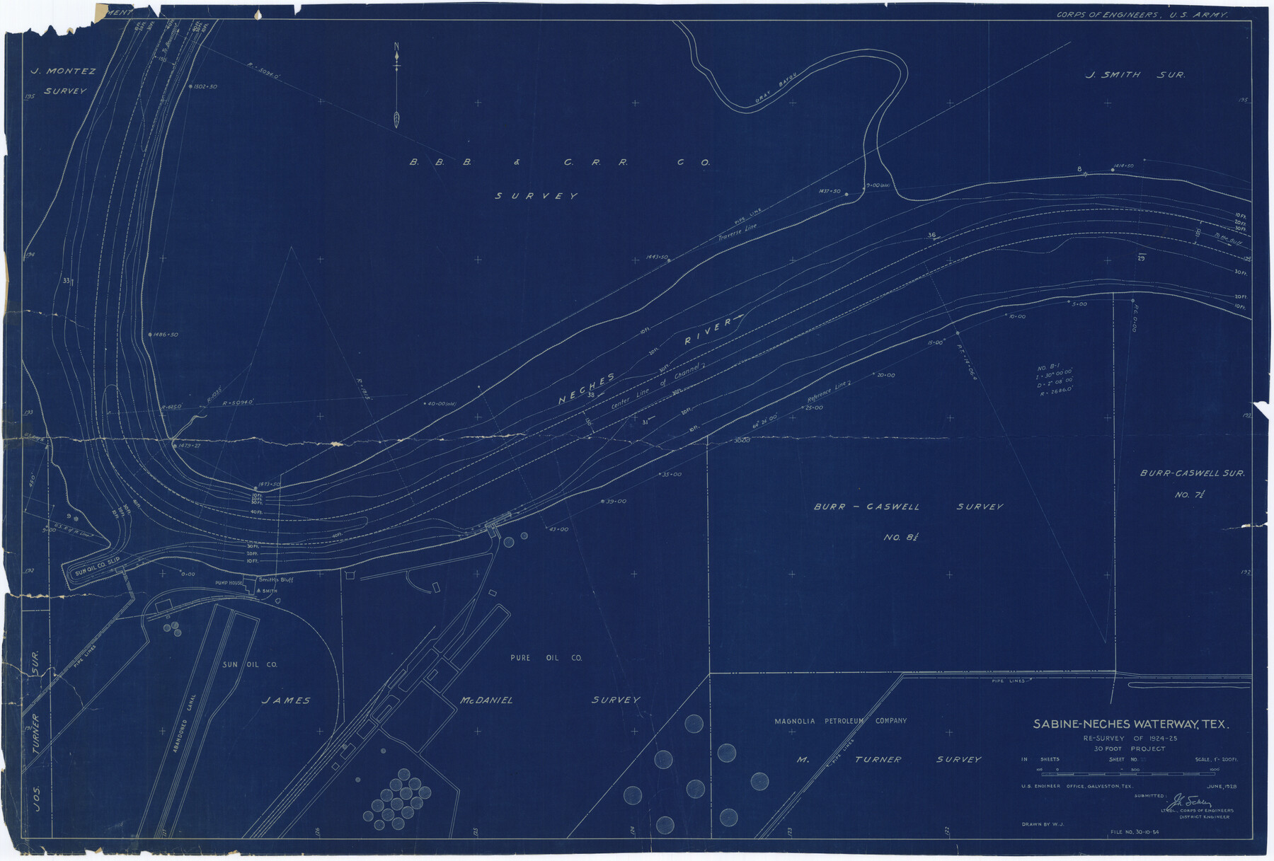
Sabine-Neches Waterway, Tex. re-survey of 1924-25, 30 foot project - Sheet no. 29
-
Map/Doc
6415
-
Collection
General Map Collection
-
Object Dates
1928 (Creation Date)
-
People and Organizations
U.S. Army Corps of Engineers (Publisher)
-
Counties
Jefferson
-
Subjects
Surveying Rolled Sketch
-
Height x Width
27.2 x 40.2 inches
69.1 x 102.1 cm
-
Medium
blueprint/diazo
-
Scale
1" = 200 feet
Part of: General Map Collection
Brazoria County Working Sketch 25

Print $20.00
- Digital $50.00
Brazoria County Working Sketch 25
1964
Size 31.2 x 44.4 inches
Map/Doc 67510

[Surveys along the Cibolo, Balcones and Leon Creeks]
![37, [Surveys along the Cibolo, Balcones and Leon Creeks], General Map Collection](https://historictexasmaps.com/wmedia_w700/maps/37.tif.jpg)
Print $2.00
- Digital $50.00
[Surveys along the Cibolo, Balcones and Leon Creeks]
1841
Size 13.3 x 7.8 inches
Map/Doc 37
Chambers County NRC Article 33.136 Sketch 3

Print $21.00
- Digital $50.00
Chambers County NRC Article 33.136 Sketch 3
2005
Size 25.0 x 36.8 inches
Map/Doc 83595
Sutton County Rolled Sketch 52

Print $20.00
- Digital $50.00
Sutton County Rolled Sketch 52
1950
Size 20.8 x 35.2 inches
Map/Doc 7892
Wichita County Working Sketch 26

Print $20.00
- Digital $50.00
Wichita County Working Sketch 26
1981
Size 13.1 x 21.0 inches
Map/Doc 72536
Presidio County Working Sketch 139

Print $20.00
- Digital $50.00
Presidio County Working Sketch 139
1990
Size 34.7 x 38.2 inches
Map/Doc 71817
Bexar County Working Sketch 14

Print $20.00
- Digital $50.00
Bexar County Working Sketch 14
1971
Size 35.2 x 37.7 inches
Map/Doc 67330
[Surveys on Trespalacios Bay]
![19, [Surveys on Trespalacios Bay], General Map Collection](https://historictexasmaps.com/wmedia_w700/maps/19.tif.jpg)
Print $2.00
- Digital $50.00
[Surveys on Trespalacios Bay]
Size 7.2 x 9.6 inches
Map/Doc 19
Palo Pinto County Working Sketch 17

Print $40.00
- Digital $50.00
Palo Pinto County Working Sketch 17
1974
Size 30.0 x 53.8 inches
Map/Doc 71400
Township 7 South Range 13 West, South Western District, Louisiana

Print $20.00
- Digital $50.00
Township 7 South Range 13 West, South Western District, Louisiana
1879
Size 19.7 x 24.7 inches
Map/Doc 65887
Franklin County Sketch File 17

Print $16.00
- Digital $50.00
Franklin County Sketch File 17
1951
Size 11.3 x 8.8 inches
Map/Doc 23026
You may also like
Taylor County Sketch File 2

Print $20.00
- Digital $50.00
Taylor County Sketch File 2
Size 13.8 x 18.4 inches
Map/Doc 12408
[State Capitol Lands and various county School Land Leagues]
![90508, [State Capitol Lands and various county School Land Leagues], Twichell Survey Records](https://historictexasmaps.com/wmedia_w700/maps/90508-1.tif.jpg)
Print $2.00
- Digital $50.00
[State Capitol Lands and various county School Land Leagues]
1903
Size 8.3 x 10.1 inches
Map/Doc 90508
Fractional Township No. 8 South Range No. 3 East of the Indian Meridian, Indian Territory

Print $20.00
- Digital $50.00
Fractional Township No. 8 South Range No. 3 East of the Indian Meridian, Indian Territory
1898
Size 19.2 x 24.4 inches
Map/Doc 75205
Walker County Working Sketch 13

Print $20.00
- Digital $50.00
Walker County Working Sketch 13
1950
Size 18.0 x 16.6 inches
Map/Doc 72293
Upton County Rolled Sketch 58

Print $20.00
- Digital $50.00
Upton County Rolled Sketch 58
Size 39.0 x 35.0 inches
Map/Doc 46125
Guadalupe County Sketch File 24

Print $4.00
- Digital $50.00
Guadalupe County Sketch File 24
1838
Size 12.9 x 8.4 inches
Map/Doc 24715
Borden County Sketch File 7

Print $8.00
- Digital $50.00
Borden County Sketch File 7
1909
Size 13.3 x 8.4 inches
Map/Doc 14723
Nueva Hispania Tabula Nova

Print $20.00
- Digital $50.00
Nueva Hispania Tabula Nova
1561
Size 9.4 x 12.3 inches
Map/Doc 93796
Dickens County Working Sketch 15

Print $20.00
- Digital $50.00
Dickens County Working Sketch 15
2011
Size 28.8 x 28.6 inches
Map/Doc 90067
Williamson County Working Sketch 6

Print $20.00
- Digital $50.00
Williamson County Working Sketch 6
1938
Size 11.2 x 18.6 inches
Map/Doc 72566
Flight Mission No. DAH-9M, Frame 201, Orange County

Print $20.00
- Digital $50.00
Flight Mission No. DAH-9M, Frame 201, Orange County
1953
Size 18.6 x 22.5 inches
Map/Doc 86869
Liberty County Rolled Sketch F

Print $20.00
- Digital $50.00
Liberty County Rolled Sketch F
Size 24.9 x 25.5 inches
Map/Doc 6621