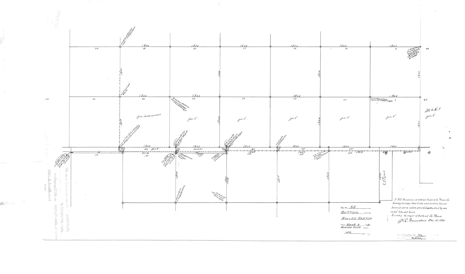
Sutton County Rolled Sketch 52
[Sketch of area between Block 14 and Block OOO]
-
Map/Doc
7892
-
Collection
General Map Collection
-
Object Dates
1950/12/15 (Creation Date)
1951/3/6 (File Date)
-
People and Organizations
H.C. Saunders (Surveyor/Engineer)
-
Counties
Sutton
-
Subjects
Surveying Rolled Sketch
-
Height x Width
20.8 x 35.2 inches
52.8 x 89.4 cm
Part of: General Map Collection
Texas-New Mexico Boundary Along Rio Grande (plats)

Print $390.00
Texas-New Mexico Boundary Along Rio Grande (plats)
1933
Map/Doc 81691
Val Verde County Working Sketch 72

Print $20.00
- Digital $50.00
Val Verde County Working Sketch 72
1967
Size 19.6 x 23.0 inches
Map/Doc 72207
Harris County Sketch File 101

Print $104.00
- Digital $50.00
Harris County Sketch File 101
1991
Size 11.3 x 8.9 inches
Map/Doc 25873
Nueces County Rolled Sketch M-12

Print $20.00
- Digital $50.00
Nueces County Rolled Sketch M-12
1913
Size 24.9 x 40.0 inches
Map/Doc 7171
Atascosa County Sketch File 38

Print $40.00
- Digital $50.00
Atascosa County Sketch File 38
Size 16.3 x 23.8 inches
Map/Doc 10868
[10th St and 29th St Groins - Galveston]
![73621, [10th St and 29th St Groins - Galveston], General Map Collection](https://historictexasmaps.com/wmedia_w700/maps/73621-1.tif.jpg)
Print $6.00
- Digital $50.00
[10th St and 29th St Groins - Galveston]
1983
Size 25.6 x 35.2 inches
Map/Doc 73621
Clay County Sketch File 33

Print $4.00
- Digital $50.00
Clay County Sketch File 33
Size 12.0 x 7.6 inches
Map/Doc 18459
Map of Ferrocarriles Nacionales de Mexico (National Railways of Mexico), Interoceanic Railway of Mexico, Vera Cruz to Isthmus Railroad, Pan-American Railroad, Texas-Mexican Railway

Print $20.00
- Digital $50.00
Map of Ferrocarriles Nacionales de Mexico (National Railways of Mexico), Interoceanic Railway of Mexico, Vera Cruz to Isthmus Railroad, Pan-American Railroad, Texas-Mexican Railway
1911
Size 9.4 x 16.1 inches
Map/Doc 95744
Duval County Boundary File 1a

Print $18.00
- Digital $50.00
Duval County Boundary File 1a
Size 12.8 x 8.4 inches
Map/Doc 52670
Flight Mission No. BRA-16M, Frame 140, Jefferson County

Print $20.00
- Digital $50.00
Flight Mission No. BRA-16M, Frame 140, Jefferson County
1953
Size 18.6 x 22.2 inches
Map/Doc 85746
Tarrant County Working Sketch 24

Print $20.00
- Digital $50.00
Tarrant County Working Sketch 24
2003
Size 26.0 x 34.9 inches
Map/Doc 78642
[Galveston, Harrisburg & San Antonio through El Paso County]
![64012, [Galveston, Harrisburg & San Antonio through El Paso County], General Map Collection](https://historictexasmaps.com/wmedia_w700/maps/64012.tif.jpg)
Print $20.00
- Digital $50.00
[Galveston, Harrisburg & San Antonio through El Paso County]
1906
Size 13.6 x 33.8 inches
Map/Doc 64012
You may also like
Post Route Map of Texas (Inset 1: Dallas-Fort Worth Area; Inset 2: Texas Panhandle)

Print $40.00
- Digital $50.00
Post Route Map of Texas (Inset 1: Dallas-Fort Worth Area; Inset 2: Texas Panhandle)
1939
Size 56.9 x 39.3 inches
Map/Doc 93668
Gaines County Working Sketch 19

Print $20.00
- Digital $50.00
Gaines County Working Sketch 19
1970
Size 46.0 x 37.5 inches
Map/Doc 69319
Map of Port Bolivar

Print $20.00
- Digital $50.00
Map of Port Bolivar
1893
Size 24.9 x 18.5 inches
Map/Doc 2191
Red River, Bois D'Arc Creek Floodway Sheet No. 8

Print $20.00
- Digital $50.00
Red River, Bois D'Arc Creek Floodway Sheet No. 8
1928
Size 17.6 x 24.8 inches
Map/Doc 65272
Cameron County Rolled Sketch 7A

Print $20.00
- Digital $50.00
Cameron County Rolled Sketch 7A
1926
Size 30.2 x 34.0 inches
Map/Doc 5384
Nolan County Sketch File 15

Print $20.00
- Digital $50.00
Nolan County Sketch File 15
1929
Size 24.5 x 22.6 inches
Map/Doc 42165
Brewster County Sketch File NS-X

Print $42.00
- Digital $50.00
Brewster County Sketch File NS-X
1882
Size 20.1 x 10.5 inches
Map/Doc 15943
The Judicial District/County of Menard. Created, January 22, 1841

Print $20.00
The Judicial District/County of Menard. Created, January 22, 1841
2020
Size 22.4 x 21.7 inches
Map/Doc 96335
Padre Island Under Six Flags

Print $40.00
- Digital $50.00
Padre Island Under Six Flags
1962
Size 59.3 x 30.3 inches
Map/Doc 3123
Floyd County Rolled Sketch 5

Print $20.00
- Digital $50.00
Floyd County Rolled Sketch 5
1892
Size 27.2 x 18.7 inches
Map/Doc 5880
Flight Mission No. CRC-4R, Frame 80, Chambers County

Print $20.00
- Digital $50.00
Flight Mission No. CRC-4R, Frame 80, Chambers County
1956
Size 18.6 x 22.4 inches
Map/Doc 84884
Southern Pacific R.R. and connections

Print $20.00
- Digital $50.00
Southern Pacific R.R. and connections
1883
Size 27.9 x 32.5 inches
Map/Doc 94270