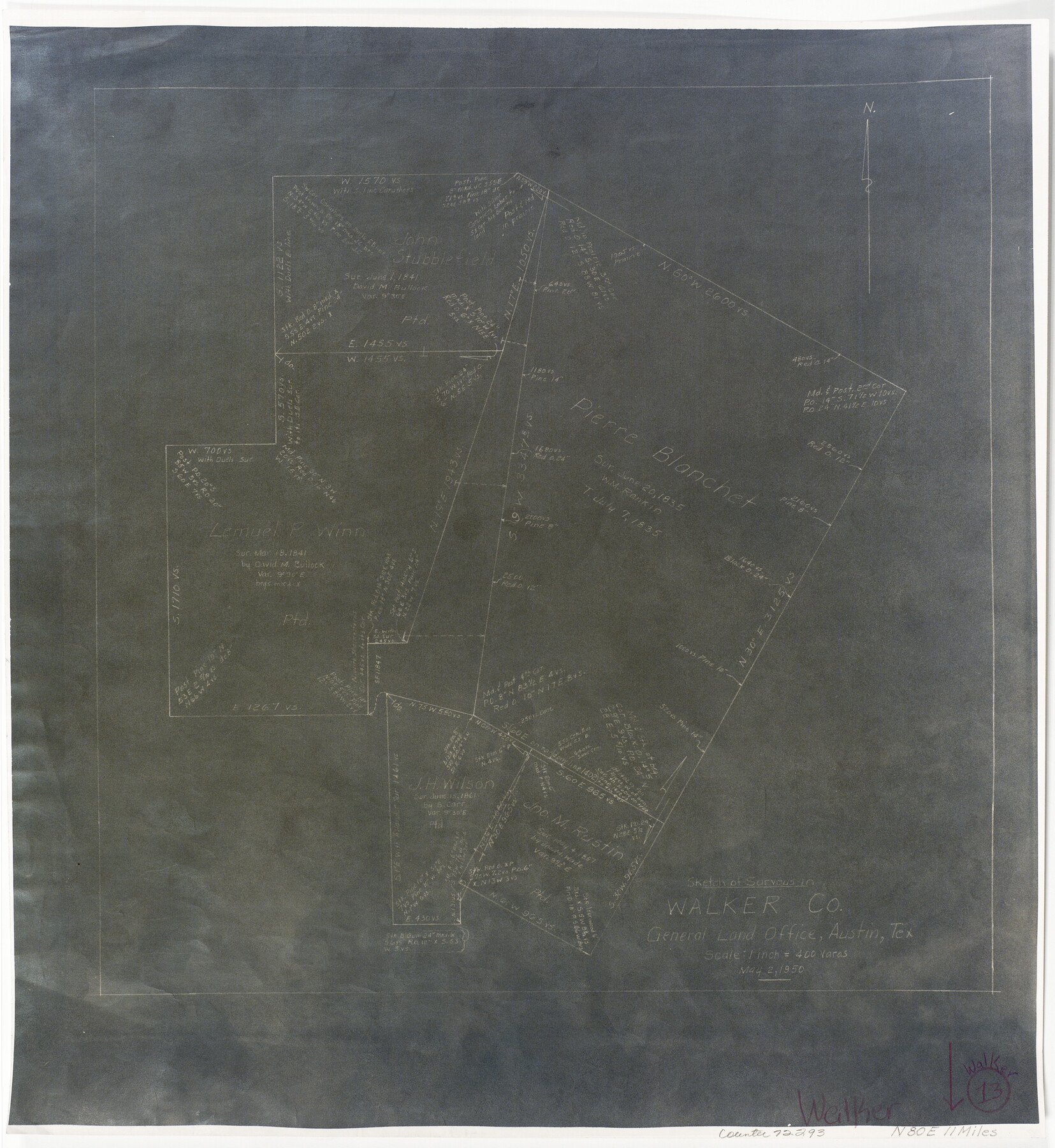
Walker County Working Sketch 13
-
Map/Doc
72293
-
Collection
General Map Collection
-
Object Dates
5/2/1950 (Creation Date)
-
Counties
Walker
-
Subjects
Surveying Working Sketch
-
Height x Width
18.0 x 16.6 inches
45.7 x 42.2 cm
-
Scale
1" = 400 varas
Part of: General Map Collection
Hunt County Rolled Sketch 3A

Print $40.00
- Digital $50.00
Hunt County Rolled Sketch 3A
1959
Size 23.9 x 52.8 inches
Map/Doc 9241
[Neches River Bed, Plat and Calculations]
![77101, [Neches River Bed, Plat and Calculations], General Map Collection](https://historictexasmaps.com/wmedia_w700/maps/77101.tif.jpg)
Print $20.00
- Digital $50.00
[Neches River Bed, Plat and Calculations]
1928
Size 23.2 x 19.8 inches
Map/Doc 77101
[Maps of surveys in Reeves & Culberson Cos]
![61132, [Maps of surveys in Reeves & Culberson Cos], General Map Collection](https://historictexasmaps.com/wmedia_w700/maps/61132.tif.jpg)
Print $20.00
- Digital $50.00
[Maps of surveys in Reeves & Culberson Cos]
1937
Size 30.8 x 24.9 inches
Map/Doc 61132
Lipscomb County Sketch File 4

Print $56.00
- Digital $50.00
Lipscomb County Sketch File 4
1910
Size 11.2 x 8.7 inches
Map/Doc 30233
Houston County Sketch File 6

Print $4.00
- Digital $50.00
Houston County Sketch File 6
1857
Size 12.0 x 4.7 inches
Map/Doc 26760
Trinity River, Hutchins Bridge Sheet

Print $20.00
- Digital $50.00
Trinity River, Hutchins Bridge Sheet
1922
Size 38.6 x 33.2 inches
Map/Doc 65190
Hidalgo County Sketch File 14

Print $20.00
- Digital $50.00
Hidalgo County Sketch File 14
Size 29.6 x 24.5 inches
Map/Doc 11764
Kendall County Sketch File 14

Print $4.00
- Digital $50.00
Kendall County Sketch File 14
1860
Size 8.1 x 10.2 inches
Map/Doc 28701
Harris County Historic Topographic 1

Print $20.00
- Digital $50.00
Harris County Historic Topographic 1
1916
Size 29.3 x 22.7 inches
Map/Doc 65811
[Bastrop District]
![3131, [Bastrop District], General Map Collection](https://historictexasmaps.com/wmedia_w700/maps/3131.tif.jpg)
Print $40.00
- Digital $50.00
[Bastrop District]
1895
Size 36.5 x 52.0 inches
Map/Doc 3131
Montague County Working Sketch 21

Print $20.00
- Digital $50.00
Montague County Working Sketch 21
1952
Size 33.1 x 39.5 inches
Map/Doc 71087
Upton County Rolled Sketch 41

Print $20.00
- Digital $50.00
Upton County Rolled Sketch 41
Size 27.4 x 40.8 inches
Map/Doc 8080
You may also like
The Inca, An Empire and its Ancestors

The Inca, An Empire and its Ancestors
Size 31.2 x 20.4 inches
Map/Doc 95936
Old Miscellaneous File 14

Print $4.00
- Digital $50.00
Old Miscellaneous File 14
1898
Size 11.2 x 8.6 inches
Map/Doc 75449
[Block H, E. L. & R. R. Block C-41, and Public School Lands]
![91386, [Block H, E. L. & R. R. Block C-41, and Public School Lands], Twichell Survey Records](https://historictexasmaps.com/wmedia_w700/maps/91386-1.tif.jpg)
Print $20.00
- Digital $50.00
[Block H, E. L. & R. R. Block C-41, and Public School Lands]
1951
Size 24.5 x 18.4 inches
Map/Doc 91386
Panola County Working Sketch 22

Print $20.00
- Digital $50.00
Panola County Working Sketch 22
1951
Map/Doc 71431
Scurry County Rolled Sketch 4

Print $20.00
- Digital $50.00
Scurry County Rolled Sketch 4
Size 35.7 x 26.0 inches
Map/Doc 7765
Metal Straight Edge Scale 1/20,000 Yard

Metal Straight Edge Scale 1/20,000 Yard
Size 24.0 x 1.6 inches
Map/Doc 97323
Randall County Boundary File 2a

Print $14.00
- Digital $50.00
Randall County Boundary File 2a
Size 9.6 x 6.1 inches
Map/Doc 58118
Hidalgo County Rolled Sketch 8

Print $20.00
- Digital $50.00
Hidalgo County Rolled Sketch 8
1905
Size 20.1 x 26.3 inches
Map/Doc 6209
Uvalde County Rolled Sketch 22

Print $20.00
- Digital $50.00
Uvalde County Rolled Sketch 22
2002
Size 30.4 x 41.0 inches
Map/Doc 78656
[Sketch for Mineral Application 24072, San Jacinto River]
![65599, [Sketch for Mineral Application 24072, San Jacinto River], General Map Collection](https://historictexasmaps.com/wmedia_w700/maps/65599.tif.jpg)
Print $20.00
- Digital $50.00
[Sketch for Mineral Application 24072, San Jacinto River]
1929
Size 23.5 x 18.0 inches
Map/Doc 65599
[Right of Way and Track Map, the Missouri, Kansas and Texas Ry. of Texas - Henrietta Division]
![64757, [Right of Way and Track Map, the Missouri, Kansas and Texas Ry. of Texas - Henrietta Division], General Map Collection](https://historictexasmaps.com/wmedia_w700/maps/64757.tif.jpg)
Print $20.00
- Digital $50.00
[Right of Way and Track Map, the Missouri, Kansas and Texas Ry. of Texas - Henrietta Division]
1918
Size 11.8 x 26.9 inches
Map/Doc 64757
Boundaries between Brownsville, Texas and Matamoros, Tam. (Mexico)

Print $20.00
Boundaries between Brownsville, Texas and Matamoros, Tam. (Mexico)
1910
Size 15.0 x 11.8 inches
Map/Doc 93559