Hunt County Rolled Sketch 3A
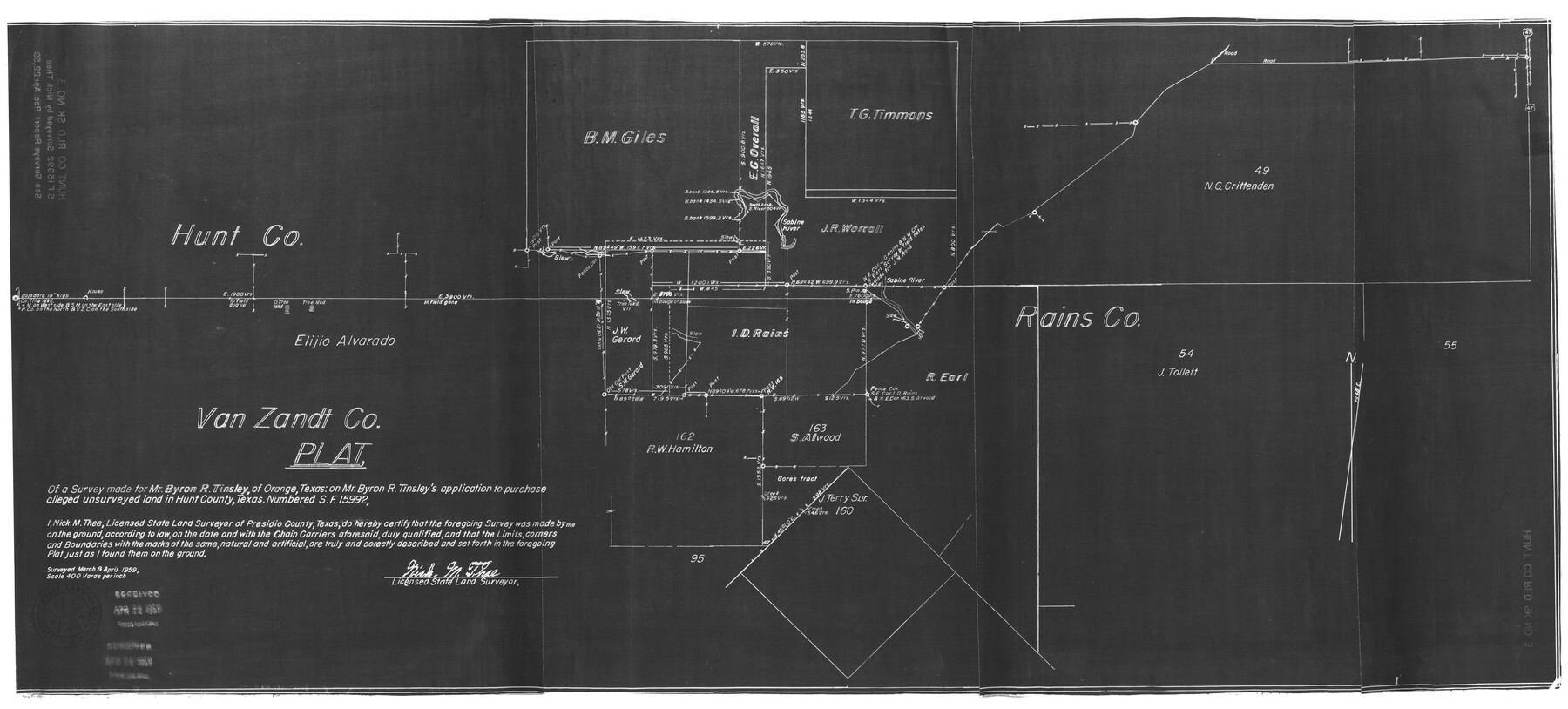
Plat of a survey made for Mr. Byron R. Tinsley, of Orange, Texas: on Mr. Byron R. Tinsley's application to purchase alleged unsurveyed land in Hunt County, Texas. Numbered SF-15992
-
Map/Doc
9241
-
Collection
General Map Collection
-
Object Dates
4/1959 (Creation Date)
4/29/1959 (File Date)
-
People and Organizations
Nick M. Thee (Surveyor/Engineer)
-
Counties
Hunt Van Zandt Rains
-
Subjects
Surveying Rolled Sketch
-
Height x Width
23.9 x 52.8 inches
60.7 x 134.1 cm
-
Medium
photostat
-
Scale
1" = 400 varas
Part of: General Map Collection
Menard County Working Sketch 28

Print $20.00
- Digital $50.00
Menard County Working Sketch 28
1963
Size 24.3 x 37.7 inches
Map/Doc 70975
Flight Mission No. DQN-1K, Frame 41, Calhoun County

Print $20.00
- Digital $50.00
Flight Mission No. DQN-1K, Frame 41, Calhoun County
1953
Size 18.5 x 22.2 inches
Map/Doc 84141
Uvalde County Working Sketch 4

Print $20.00
- Digital $50.00
Uvalde County Working Sketch 4
1920
Size 23.1 x 17.1 inches
Map/Doc 72074
Hays County Sketch File AB

Print $16.00
- Digital $50.00
Hays County Sketch File AB
1891
Size 6.3 x 8.7 inches
Map/Doc 26189
Map of the River Sabine from its mouth on the Gulf of Mexico in the Sea to Logan's Ferry in Latitude 31°58'24" North

Print $40.00
- Digital $50.00
Map of the River Sabine from its mouth on the Gulf of Mexico in the Sea to Logan's Ferry in Latitude 31°58'24" North
1842
Size 173.2 x 31.0 inches
Map/Doc 1744

Shelby County Sketch File 6

Print $8.00
- Digital $50.00
Shelby County Sketch File 6
1854
Size 12.4 x 8.2 inches
Map/Doc 36601
Refugio County Working Sketch 4

Print $20.00
- Digital $50.00
Refugio County Working Sketch 4
1937
Size 33.2 x 31.4 inches
Map/Doc 63513
Atascosa County Sketch File 22

Print $6.00
- Digital $50.00
Atascosa County Sketch File 22
Size 14.2 x 8.6 inches
Map/Doc 13789
Map of Hutchinson County

Print $20.00
- Digital $50.00
Map of Hutchinson County
1898
Size 41.0 x 35.4 inches
Map/Doc 16856
Dickens County Sketch File M

Print $59.00
- Digital $50.00
Dickens County Sketch File M
1908
Size 14.6 x 9.1 inches
Map/Doc 20911
Hutchinson County Rolled Sketch 40

Print $20.00
- Digital $50.00
Hutchinson County Rolled Sketch 40
1981
Size 26.2 x 37.4 inches
Map/Doc 6305
You may also like
Kansas and Nebraska

Print $20.00
- Digital $50.00
Kansas and Nebraska
Size 30.8 x 19.4 inches
Map/Doc 93994
Presidio County Rolled Sketch 40

Print $20.00
- Digital $50.00
Presidio County Rolled Sketch 40
1907
Size 16.5 x 21.5 inches
Map/Doc 7337
Potter County Working Sketch 9

Print $40.00
- Digital $50.00
Potter County Working Sketch 9
1966
Size 46.4 x 48.6 inches
Map/Doc 71669
The Mercer Colony. January 29, 1844

Print $20.00
The Mercer Colony. January 29, 1844
2020
Size 19.8 x 21.7 inches
Map/Doc 96361
Flight Mission No. DQO-3K, Frame 24, Galveston County

Print $20.00
- Digital $50.00
Flight Mission No. DQO-3K, Frame 24, Galveston County
1952
Size 18.7 x 22.4 inches
Map/Doc 85065
Map of Wharton County

Print $20.00
- Digital $50.00
Map of Wharton County
1878
Size 22.4 x 29.9 inches
Map/Doc 4134
Bandera County Working Sketch 17

Print $20.00
- Digital $50.00
Bandera County Working Sketch 17
1943
Size 21.2 x 27.5 inches
Map/Doc 67613
Montgomery County Sketch File 15

Print $4.00
- Digital $50.00
Montgomery County Sketch File 15
1906
Size 9.4 x 8.5 inches
Map/Doc 31817
Edwards County Working Sketch 21

Print $20.00
- Digital $50.00
Edwards County Working Sketch 21
1935
Size 26.7 x 32.0 inches
Map/Doc 68897
Map Showing Ten Divisions of the C. C. Slaughter Cattle Company's Ranch in Hockley and Cochran Counties, Texas

Print $3.00
- Digital $50.00
Map Showing Ten Divisions of the C. C. Slaughter Cattle Company's Ranch in Hockley and Cochran Counties, Texas
Size 13.2 x 10.7 inches
Map/Doc 91126
Brewster County Working Sketch 115

Print $40.00
- Digital $50.00
Brewster County Working Sketch 115
1985
Size 49.6 x 43.4 inches
Map/Doc 67715
