Atascosa County Sketch File 22
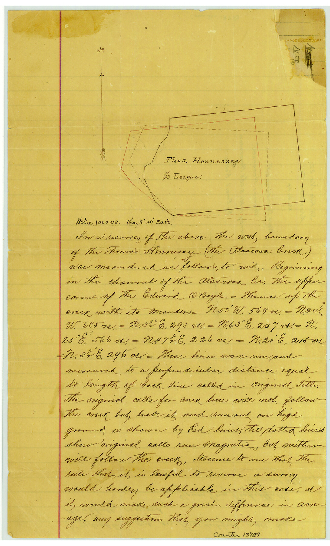
[Sketch and statement of west boundary of Thomas Hennesee survey]
-
Map/Doc
13789
-
Collection
General Map Collection
-
People and Organizations
Emeil Kelley (Surveyor/Engineer)
-
Counties
Atascosa
-
Subjects
Surveying Sketch File
-
Height x Width
14.2 x 8.6 inches
36.1 x 21.8 cm
-
Medium
paper, manuscript
-
Scale
1" = 1000 varas
-
Features
Atascosa Creek
Part of: General Map Collection
San Patricio County Sketch File 44

Print $12.00
- Digital $50.00
San Patricio County Sketch File 44
1942
Size 11.4 x 8.9 inches
Map/Doc 36267
Coke County Rolled Sketch 32

Print $20.00
- Digital $50.00
Coke County Rolled Sketch 32
1982
Size 36.1 x 21.1 inches
Map/Doc 5527
Flight Mission No. BRA-7M, Frame 40, Jefferson County

Print $20.00
- Digital $50.00
Flight Mission No. BRA-7M, Frame 40, Jefferson County
1953
Size 18.7 x 22.3 inches
Map/Doc 85491
Liberty County Rolled Sketch 18

Print $11.00
- Digital $50.00
Liberty County Rolled Sketch 18
1859
Size 10.1 x 15.2 inches
Map/Doc 46540
Motley County Sketch File B3 (N)

Print $10.00
- Digital $50.00
Motley County Sketch File B3 (N)
1900
Size 6.5 x 11.9 inches
Map/Doc 31974
Webb County Rolled Sketch 50

Print $20.00
- Digital $50.00
Webb County Rolled Sketch 50
1943
Size 38.2 x 42.6 inches
Map/Doc 10125
Webb County Sketch File 12a

Print $20.00
- Digital $50.00
Webb County Sketch File 12a
1886
Size 20.7 x 31.4 inches
Map/Doc 12628
Flight Mission No. DAH-9M, Frame 155, Orange County

Print $20.00
- Digital $50.00
Flight Mission No. DAH-9M, Frame 155, Orange County
1953
Size 18.6 x 22.6 inches
Map/Doc 86854
Jeff Davis County Boundary File 1a

Print $8.00
- Digital $50.00
Jeff Davis County Boundary File 1a
Size 14.3 x 8.8 inches
Map/Doc 55501
Jackson County Working Sketch 11

Print $40.00
- Digital $50.00
Jackson County Working Sketch 11
1994
Size 33.8 x 48.4 inches
Map/Doc 66459
Navarro County Sketch File 14

Print $4.00
- Digital $50.00
Navarro County Sketch File 14
1873
Size 8.4 x 10.2 inches
Map/Doc 32326

You may also like
Leon County Working Sketch 22

Print $20.00
- Digital $50.00
Leon County Working Sketch 22
1965
Size 27.9 x 31.1 inches
Map/Doc 70421
Comal County Rolled Sketch 1

Print $20.00
- Digital $50.00
Comal County Rolled Sketch 1
1972
Size 24.2 x 19.6 inches
Map/Doc 5535
Bandera County Working Sketch 30

Print $20.00
- Digital $50.00
Bandera County Working Sketch 30
1969
Size 29.9 x 37.4 inches
Map/Doc 67626
Northern Part of Laguna Madre

Print $20.00
- Digital $50.00
Northern Part of Laguna Madre
1972
Size 44.2 x 35.0 inches
Map/Doc 73529
Bandera County Working Sketch 10

Print $20.00
- Digital $50.00
Bandera County Working Sketch 10
1922
Size 17.9 x 19.4 inches
Map/Doc 67603
Schleicher Co.

Print $20.00
- Digital $50.00
Schleicher Co.
1893
Size 20.8 x 29.3 inches
Map/Doc 63025
Map of Tascosa, Oldham County, Texas

Print $40.00
- Digital $50.00
Map of Tascosa, Oldham County, Texas
Size 34.8 x 66.8 inches
Map/Doc 89711

Flight Mission No. DQN-7K, Frame 40, Calhoun County

Print $20.00
- Digital $50.00
Flight Mission No. DQN-7K, Frame 40, Calhoun County
1953
Size 18.5 x 22.2 inches
Map/Doc 84478
Flight Mission No. CRC-4R, Frame 93, Chambers County

Print $20.00
- Digital $50.00
Flight Mission No. CRC-4R, Frame 93, Chambers County
1956
Size 18.4 x 22.3 inches
Map/Doc 84890
Map of Archer County

Print $20.00
- Digital $50.00
Map of Archer County
1886
Size 24.4 x 20.5 inches
Map/Doc 3240
Flight Mission No. DCL-6C, Frame 116, Kenedy County

Print $20.00
- Digital $50.00
Flight Mission No. DCL-6C, Frame 116, Kenedy County
1943
Size 18.6 x 22.2 inches
Map/Doc 85946