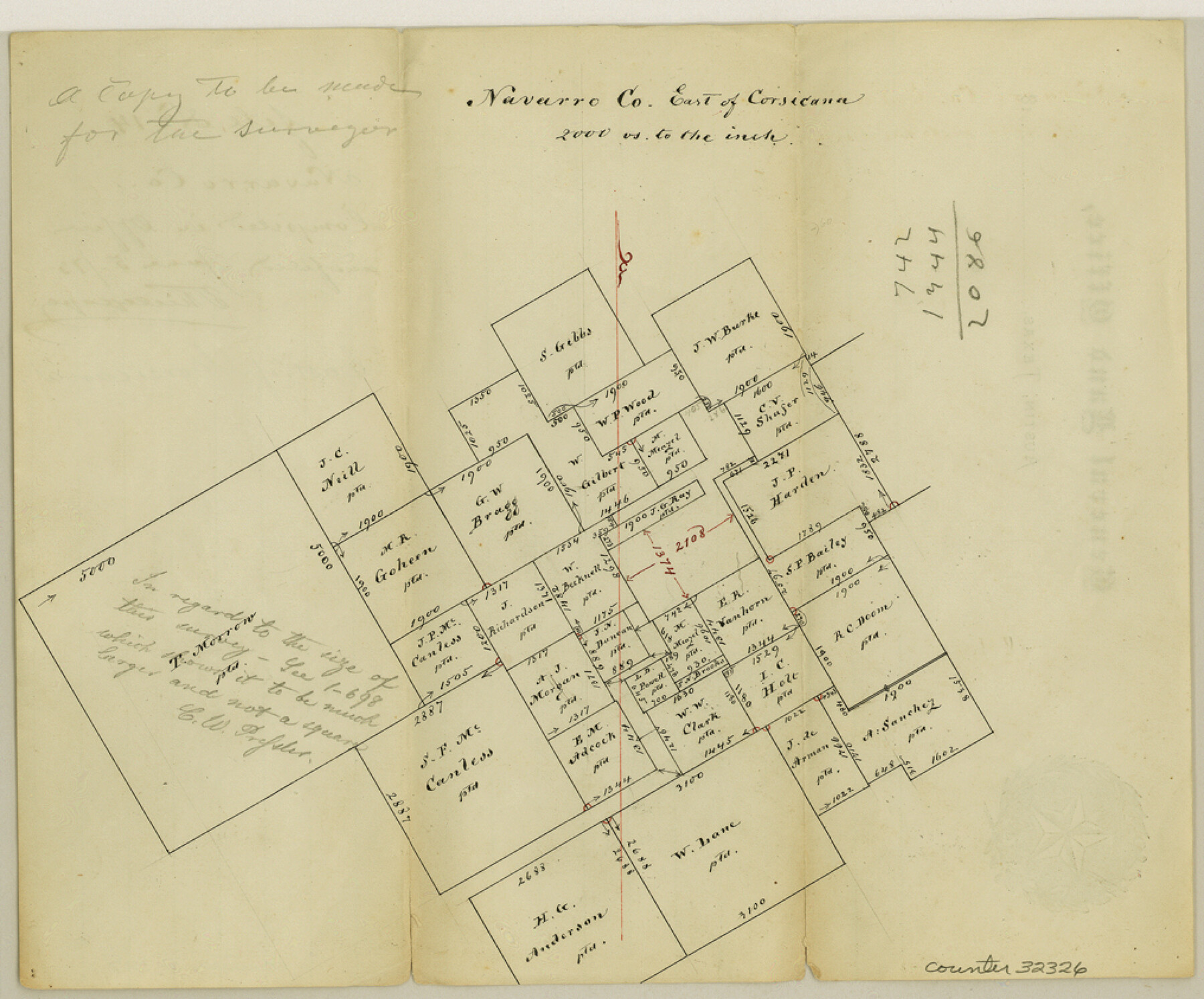
Navarro County Sketch File 14
[Office sketch of area east of Corsicana]
-
Map/Doc
32326
-
Collection
General Map Collection
-
Object Dates
6/5/1873 (Creation Date)
-
Counties
Navarro
-
Subjects
Surveying Sketch File
-
Height x Width
8.4 x 10.2 inches
21.3 x 25.9 cm
-
Medium
paper, manuscript
-
Scale
1" = 2000 varas
Part of: General Map Collection
Cooke County Rolled Sketch 2

Print $20.00
- Digital $50.00
Cooke County Rolled Sketch 2
1944
Size 29.4 x 28.1 inches
Map/Doc 5561
Baie de Galvez-Town

Print $20.00
- Digital $50.00
Baie de Galvez-Town
1820
Size 10.3 x 12.9 inches
Map/Doc 95832
Hunt County Sketch File 14

Print $4.00
- Digital $50.00
Hunt County Sketch File 14
1851
Size 8.5 x 15.2 inches
Map/Doc 27107
Comanche County Sketch File 22

Print $4.00
- Digital $50.00
Comanche County Sketch File 22
1873
Size 15.2 x 9.2 inches
Map/Doc 19106
Kerr County Working Sketch 19

Print $20.00
- Digital $50.00
Kerr County Working Sketch 19
1959
Size 34.5 x 41.3 inches
Map/Doc 70050
Armstrong County

Print $20.00
- Digital $50.00
Armstrong County
1933
Size 44.0 x 41.3 inches
Map/Doc 1773
Fisher County

Print $20.00
- Digital $50.00
Fisher County
1944
Size 41.4 x 36.1 inches
Map/Doc 77279
Carte d'une partie des Côtes de l'Inde depuis Bombay jus'qu'a Surate, avec le détail des Habitations de cette Côte

Print $20.00
- Digital $50.00
Carte d'une partie des Côtes de l'Inde depuis Bombay jus'qu'a Surate, avec le détail des Habitations de cette Côte
1782
Size 13.2 x 18.2 inches
Map/Doc 97119
Pecos County Working Sketch 129

Print $20.00
- Digital $50.00
Pecos County Working Sketch 129
1976
Map/Doc 71603
Wilbarger County Rolled Sketch 10

Print $20.00
- Digital $50.00
Wilbarger County Rolled Sketch 10
1983
Size 37.6 x 23.8 inches
Map/Doc 8259
Chart of the Harbour of San [Luis]
![72763, Chart of the Harbour of San [Luis], General Map Collection](https://historictexasmaps.com/wmedia_w700/maps/72763.tif.jpg)
Print $20.00
- Digital $50.00
Chart of the Harbour of San [Luis]
1846
Size 27.7 x 18.3 inches
Map/Doc 72763
Johnson County Working Sketch 11

Print $20.00
- Digital $50.00
Johnson County Working Sketch 11
1953
Size 28.7 x 22.4 inches
Map/Doc 66624
You may also like
[Littlefield & White Survey, Kimble County, Texas]
![570, [Littlefield & White Survey, Kimble County, Texas], Maddox Collection](https://historictexasmaps.com/wmedia_w700/maps/0570.tif.jpg)
Print $20.00
- Digital $50.00
[Littlefield & White Survey, Kimble County, Texas]
Size 18.6 x 14.2 inches
Map/Doc 570
General Highway Map, Collin County, Texas

Print $20.00
General Highway Map, Collin County, Texas
1939
Size 18.6 x 25.0 inches
Map/Doc 79052
Waller County Sketch File 3

Print $4.00
- Digital $50.00
Waller County Sketch File 3
Size 13.0 x 8.4 inches
Map/Doc 39598
Kent County Boundary File 2

Print $4.00
- Digital $50.00
Kent County Boundary File 2
Size 10.1 x 8.2 inches
Map/Doc 55822
Nueces County Rolled Sketch 54

Print $67.00
- Digital $50.00
Nueces County Rolled Sketch 54
1978
Size 9.8 x 15.0 inches
Map/Doc 47875
Terrell County Working Sketch 70

Print $20.00
- Digital $50.00
Terrell County Working Sketch 70
1979
Size 39.0 x 36.5 inches
Map/Doc 69591
Flight Mission No. CGI-1N, Frame 180, Cameron County

Print $20.00
- Digital $50.00
Flight Mission No. CGI-1N, Frame 180, Cameron County
1955
Size 18.5 x 22.2 inches
Map/Doc 84515
[Sketch showing town lots near railroad track]
![92087, [Sketch showing town lots near railroad track], Twichell Survey Records](https://historictexasmaps.com/wmedia_w700/maps/92087-1.tif.jpg)
Print $20.00
- Digital $50.00
[Sketch showing town lots near railroad track]
Size 22.9 x 9.4 inches
Map/Doc 92087
[Northeast portion of Grayson County]
![78364, [Northeast portion of Grayson County], General Map Collection](https://historictexasmaps.com/wmedia_w700/maps/78364.tif.jpg)
Print $20.00
- Digital $50.00
[Northeast portion of Grayson County]
Size 12.0 x 14.0 inches
Map/Doc 78364
Controlled Mosaic by Jack Amman Photogrammetric Engineers, Inc - Sheet 42

Print $20.00
- Digital $50.00
Controlled Mosaic by Jack Amman Photogrammetric Engineers, Inc - Sheet 42
1954
Size 20.0 x 24.0 inches
Map/Doc 83501
Parker County Sketch File C

Print $4.00
- Digital $50.00
Parker County Sketch File C
1857
Size 6.1 x 7.8 inches
Map/Doc 33512
Flight Mission No. DQO-1K, Frame 20, Galveston County

Print $20.00
- Digital $50.00
Flight Mission No. DQO-1K, Frame 20, Galveston County
1952
Size 19.0 x 22.5 inches
Map/Doc 84979