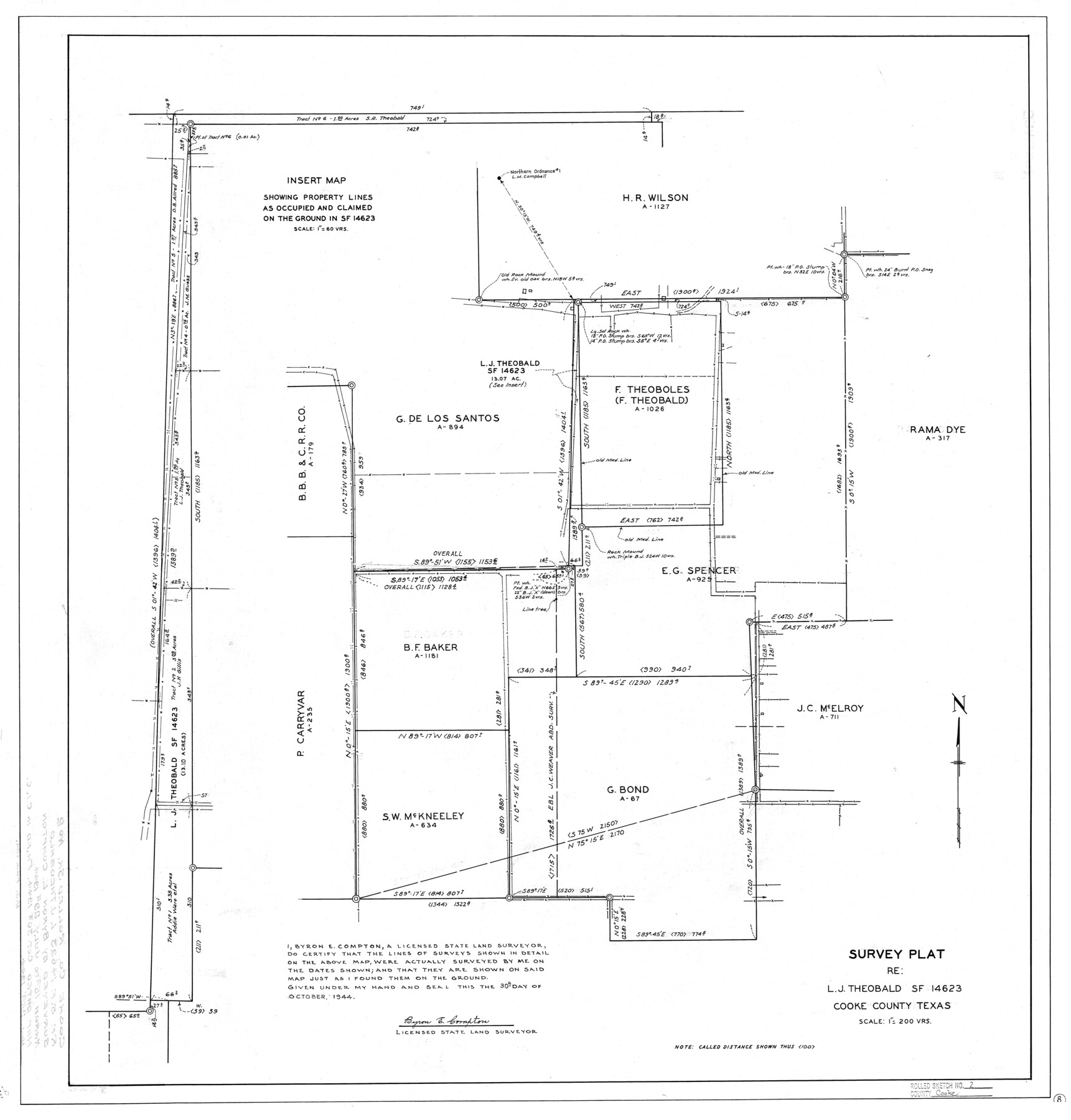
Cooke County Rolled Sketch 2
Survey Plat Re: L.J. Thobald SF.14623, Cooke County, Texas
-
Map/Doc
5561
-
Collection
General Map Collection
-
Object Dates
10/30/1944 (Creation Date)
-
People and Organizations
Byron E. Compton (Surveyor/Engineer)
-
Counties
Cooke
-
Subjects
Surveying Rolled Sketch
-
Height x Width
29.4 x 28.1 inches
74.7 x 71.4 cm
-
Scale
1" = 200 varas
Part of: General Map Collection
Guadalupe County Working Sketch 12

Print $20.00
- Digital $50.00
Guadalupe County Working Sketch 12
2005
Size 29.1 x 23.5 inches
Map/Doc 83571
Dimmit County Sketch File 1

Print $42.00
- Digital $50.00
Dimmit County Sketch File 1
1851
Size 8.8 x 7.5 inches
Map/Doc 21050
Gregg County Rolled Sketch JE

Print $94.00
- Digital $50.00
Gregg County Rolled Sketch JE
1931
Size 30.9 x 42.9 inches
Map/Doc 9023
Rusk County Rolled Sketch 11

Print $20.00
- Digital $50.00
Rusk County Rolled Sketch 11
1956
Size 33.2 x 43.3 inches
Map/Doc 9877
Rockwall County Boundary File 6

Print $48.00
- Digital $50.00
Rockwall County Boundary File 6
Size 14.0 x 8.6 inches
Map/Doc 58420
Rusk County Working Sketch 31

Print $20.00
- Digital $50.00
Rusk County Working Sketch 31
1923
Size 22.6 x 17.4 inches
Map/Doc 63668
Hopkins County Sketch File 5

Print $4.00
- Digital $50.00
Hopkins County Sketch File 5
Size 10.3 x 8.2 inches
Map/Doc 26687
Harris County Working Sketch 80

Print $20.00
- Digital $50.00
Harris County Working Sketch 80
1968
Size 35.8 x 29.9 inches
Map/Doc 65972
Goliad County Sketch File 40

Print $20.00
- Digital $50.00
Goliad County Sketch File 40
1949
Size 23.9 x 36.0 inches
Map/Doc 11572
Reagan County Rolled Sketch 34

Print $40.00
- Digital $50.00
Reagan County Rolled Sketch 34
1956
Size 53.2 x 40.3 inches
Map/Doc 9829
Coke County Rolled Sketch 13

Print $40.00
- Digital $50.00
Coke County Rolled Sketch 13
Size 44.5 x 69.9 inches
Map/Doc 8627
Cottle County Sketch File 11

Print $40.00
- Digital $50.00
Cottle County Sketch File 11
Size 12.9 x 13.3 inches
Map/Doc 19489
You may also like
Goliad County Rolled Sketch 7

Print $69.00
- Digital $50.00
Goliad County Rolled Sketch 7
1849
Size 10.6 x 16.1 inches
Map/Doc 45254

Culberson County Working Sketch 66

Print $40.00
- Digital $50.00
Culberson County Working Sketch 66
1975
Size 52.1 x 33.2 inches
Map/Doc 68520
Spanish and Mexican Land Grants in Texas

Print $20.00
Spanish and Mexican Land Grants in Texas
2015
Size 34.0 x 44.0 inches
Map/Doc 93755
Galveston County Sketch File 1

Print $4.00
- Digital $50.00
Galveston County Sketch File 1
Size 12.7 x 8.5 inches
Map/Doc 23346
Reeves County Working Sketch 61

Print $20.00
- Digital $50.00
Reeves County Working Sketch 61
1982
Size 32.1 x 31.4 inches
Map/Doc 63504
Moore County Sketch File 11

Print $20.00
- Digital $50.00
Moore County Sketch File 11
Size 18.2 x 31.3 inches
Map/Doc 42129
Working Sketch Bastrop County

Print $20.00
- Digital $50.00
Working Sketch Bastrop County
1923
Size 23.1 x 13.7 inches
Map/Doc 90150
Map Shelby County

Print $20.00
- Digital $50.00
Map Shelby County
1852
Size 20.1 x 31.5 inches
Map/Doc 4029
Crosby County Boundary File 5a

Print $60.00
- Digital $50.00
Crosby County Boundary File 5a
Size 8.0 x 35.4 inches
Map/Doc 52044

Upton County Sketch File 38

Print $8.00
- Digital $50.00
Upton County Sketch File 38
1953
Size 11.1 x 8.9 inches
Map/Doc 38903