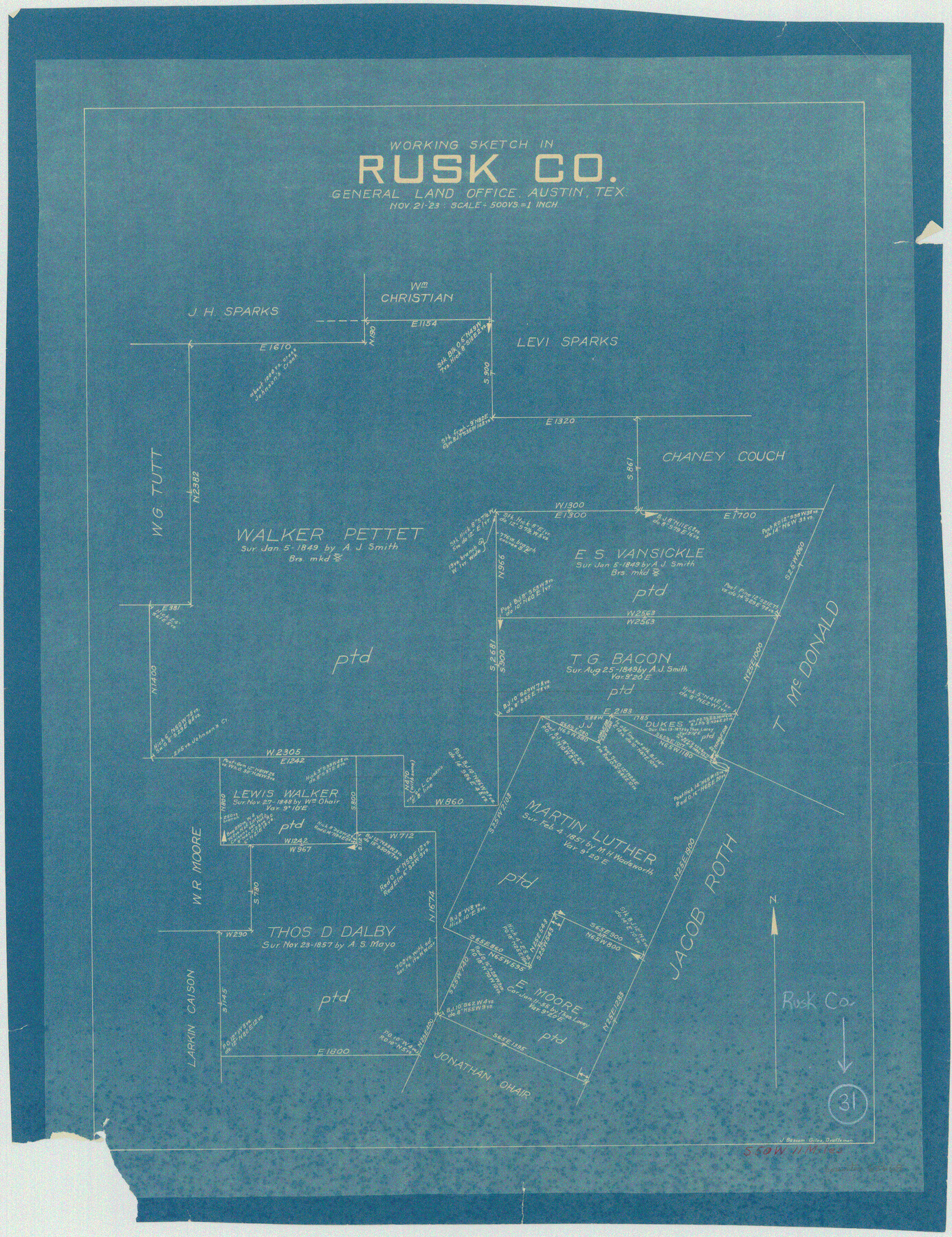
Rusk County Working Sketch 31
-
Map/Doc
63668
-
Collection
General Map Collection
-
Object Dates
11/21/1923 (Creation Date)
-
People and Organizations
J. Bascom Giles (Draftsman)
-
Counties
Rusk
-
Subjects
Surveying Working Sketch
-
Height x Width
22.6 x 17.4 inches
57.4 x 44.2 cm
-
Scale
1" = 500 varas
Part of: General Map Collection
Flight Mission No. DQN-6K, Frame 10, Calhoun County

Print $20.00
- Digital $50.00
Flight Mission No. DQN-6K, Frame 10, Calhoun County
1953
Size 18.5 x 22.3 inches
Map/Doc 84432
Flight Mission No. DCL-6C, Frame 20, Kenedy County

Print $20.00
- Digital $50.00
Flight Mission No. DCL-6C, Frame 20, Kenedy County
1943
Size 18.7 x 22.4 inches
Map/Doc 85877
Brewster County Rolled Sketch 114

Print $20.00
- Digital $50.00
Brewster County Rolled Sketch 114
1964
Size 11.4 x 18.2 inches
Map/Doc 5282
No. 3 Chart of Channel connecting Corpus Christi Bay with Aransas Bay, Texas

Print $20.00
- Digital $50.00
No. 3 Chart of Channel connecting Corpus Christi Bay with Aransas Bay, Texas
1878
Size 18.4 x 28.0 inches
Map/Doc 72771
Brazos County Working Sketch 4

Print $20.00
- Digital $50.00
Brazos County Working Sketch 4
1976
Size 22.5 x 20.6 inches
Map/Doc 67479
Presidio County Working Sketch 6

Print $20.00
- Digital $50.00
Presidio County Working Sketch 6
1920
Size 19.1 x 37.2 inches
Map/Doc 71680
Montgomery County Rolled Sketch 48

Print $20.00
- Digital $50.00
Montgomery County Rolled Sketch 48
2007
Size 11.2 x 17.2 inches
Map/Doc 89278
Harris County Working Sketch 80

Print $20.00
- Digital $50.00
Harris County Working Sketch 80
1968
Size 35.8 x 29.9 inches
Map/Doc 65972
Washington County Sketch File 3

Print $4.00
- Digital $50.00
Washington County Sketch File 3
1860
Size 8.1 x 9.2 inches
Map/Doc 39648
Wilbarger Co.

Print $20.00
- Digital $50.00
Wilbarger Co.
1949
Size 47.8 x 38.8 inches
Map/Doc 73324
Northeast Part of Crockett County

Print $20.00
- Digital $50.00
Northeast Part of Crockett County
1976
Size 35.6 x 46.1 inches
Map/Doc 73120
Crockett County Rolled Sketch CP
Print $20.00
- Digital $50.00
Crockett County Rolled Sketch CP
1928
Size 39.9 x 30.8 inches
Map/Doc 8695
You may also like
Nueces County Rolled Sketch 71

Print $247.00
Nueces County Rolled Sketch 71
1980
Size 37.9 x 24.7 inches
Map/Doc 6924
Map of the Lands Surveyed by the Memphis, El Paso & Pacific R.R. Company

Print $20.00
- Digital $50.00
Map of the Lands Surveyed by the Memphis, El Paso & Pacific R.R. Company
1859
Size 15.8 x 19.0 inches
Map/Doc 4844
Real County Working Sketch 89

Print $20.00
- Digital $50.00
Real County Working Sketch 89
Size 28.0 x 37.1 inches
Map/Doc 71981
[Blocks C41, C42, A1, and vicinity]
![92641, [Blocks C41, C42, A1, and vicinity], Twichell Survey Records](https://historictexasmaps.com/wmedia_w700/maps/92641-1.tif.jpg)
Print $20.00
- Digital $50.00
[Blocks C41, C42, A1, and vicinity]
Size 15.7 x 43.3 inches
Map/Doc 92641
Mrs. R. L. Westerman Subdivision of 2 1/2 Acres out of North Half of Survey Number 1, Block Number 36, Township 5 North. Dawson County, Texas

Print $20.00
- Digital $50.00
Mrs. R. L. Westerman Subdivision of 2 1/2 Acres out of North Half of Survey Number 1, Block Number 36, Township 5 North. Dawson County, Texas
1924
Size 18.6 x 24.5 inches
Map/Doc 92591
[Nueces Bay, Mustang Island and Padre Island]
![73463, [Nueces Bay, Mustang Island and Padre Island], General Map Collection](https://historictexasmaps.com/wmedia_w700/maps/73463-1.tif.jpg)
Print $4.00
- Digital $50.00
[Nueces Bay, Mustang Island and Padre Island]
1887
Size 18.5 x 26.2 inches
Map/Doc 73463
Liberty County Rolled Sketch JLW

Print $40.00
- Digital $50.00
Liberty County Rolled Sketch JLW
1935
Size 28.0 x 85.5 inches
Map/Doc 9665
General Highway Map, Bowie County, Texas

Print $20.00
General Highway Map, Bowie County, Texas
1961
Size 18.2 x 25.0 inches
Map/Doc 79380
Sketch showing the Fred Turner surveys in Pecos County, Texas

Print $20.00
- Digital $50.00
Sketch showing the Fred Turner surveys in Pecos County, Texas
1928
Size 28.9 x 36.0 inches
Map/Doc 91590
Map of Brett Ranch situated in McMullen & La Salle Counties

Print $20.00
- Digital $50.00
Map of Brett Ranch situated in McMullen & La Salle Counties
Size 20.0 x 22.3 inches
Map/Doc 5068
Reagan County Sketch File 6

Print $20.00
- Digital $50.00
Reagan County Sketch File 6
1927
Size 23.4 x 14.1 inches
Map/Doc 12215
Map of Liberty County Texas

Print $20.00
- Digital $50.00
Map of Liberty County Texas
1879
Size 25.4 x 25.3 inches
Map/Doc 42994