Brewster County Rolled Sketch 114
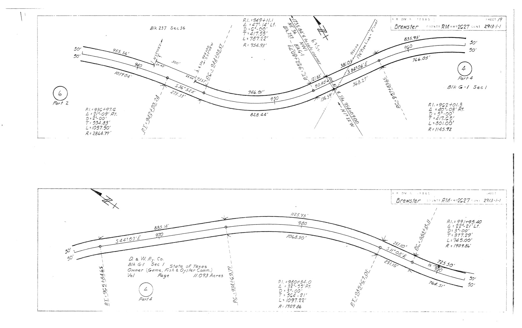
Plans of proposed State Highway Right of Way, RM Highway 2627, Brewster County, Control 2913-1-1 from: US 383, 38 mi. S of Marathon, SE to: Heath Crossing on Rio Grande (Sheet 19)
-
Map/Doc
5282
-
Collection
General Map Collection
-
Object Dates
1965/3/29 (File Date)
1964/12/3 (Creation Date)
-
People and Organizations
State Highway Department (Publisher)
-
Counties
Brewster
-
Subjects
Surveying Rolled Sketch
-
Height x Width
11.4 x 18.2 inches
29.0 x 46.2 cm
-
Medium
blueprint/diazo
-
Comments
This is one sheet of a set of 29 maps. For the complete set, see map numbers 5264-5292.
Related maps
Brewster County Rolled Sketch 114

Print $20.00
- Digital $50.00
Brewster County Rolled Sketch 114
1964
Size 11.8 x 18.5 inches
Map/Doc 5264
Brewster County Rolled Sketch 114

Print $20.00
- Digital $50.00
Brewster County Rolled Sketch 114
1964
Size 11.7 x 18.4 inches
Map/Doc 5265
Brewster County Rolled Sketch 114

Print $20.00
- Digital $50.00
Brewster County Rolled Sketch 114
1964
Size 11.7 x 18.6 inches
Map/Doc 5266
Brewster County Rolled Sketch 114

Print $20.00
- Digital $50.00
Brewster County Rolled Sketch 114
1964
Size 11.7 x 18.4 inches
Map/Doc 5267
Brewster County Rolled Sketch 114

Print $20.00
- Digital $50.00
Brewster County Rolled Sketch 114
1964
Size 23.8 x 18.9 inches
Map/Doc 5268
Brewster County Rolled Sketch 114

Print $20.00
- Digital $50.00
Brewster County Rolled Sketch 114
1964
Size 11.0 x 18.3 inches
Map/Doc 5269
Brewster County Rolled Sketch 114

Print $20.00
- Digital $50.00
Brewster County Rolled Sketch 114
1964
Size 11.1 x 18.4 inches
Map/Doc 5270
Brewster County Rolled Sketch 114

Print $20.00
- Digital $50.00
Brewster County Rolled Sketch 114
1964
Size 11.5 x 18.5 inches
Map/Doc 5271
Brewster County Rolled Sketch 114

Print $20.00
- Digital $50.00
Brewster County Rolled Sketch 114
1964
Size 11.6 x 18.3 inches
Map/Doc 5272
Brewster County Rolled Sketch 114

Print $20.00
- Digital $50.00
Brewster County Rolled Sketch 114
1964
Size 11.6 x 17.3 inches
Map/Doc 5273
Brewster County Rolled Sketch 114

Print $20.00
- Digital $50.00
Brewster County Rolled Sketch 114
1964
Size 11.5 x 17.6 inches
Map/Doc 5274
Brewster County Rolled Sketch 114

Print $20.00
- Digital $50.00
Brewster County Rolled Sketch 114
1964
Size 11.6 x 18.5 inches
Map/Doc 5275
Brewster County Rolled Sketch 114

Print $20.00
- Digital $50.00
Brewster County Rolled Sketch 114
1964
Size 11.7 x 18.3 inches
Map/Doc 5276
Brewster County Rolled Sketch 114

Print $20.00
- Digital $50.00
Brewster County Rolled Sketch 114
1964
Size 11.4 x 18.4 inches
Map/Doc 5277
Brewster County Rolled Sketch 114

Print $20.00
- Digital $50.00
Brewster County Rolled Sketch 114
1964
Size 12.0 x 18.4 inches
Map/Doc 5278
Brewster County Rolled Sketch 114

Print $20.00
- Digital $50.00
Brewster County Rolled Sketch 114
1964
Size 11.9 x 18.4 inches
Map/Doc 5279
Brewster County Rolled Sketch 114

Print $20.00
- Digital $50.00
Brewster County Rolled Sketch 114
1964
Size 11.9 x 18.3 inches
Map/Doc 5280
Brewster County Rolled Sketch 114

Print $20.00
- Digital $50.00
Brewster County Rolled Sketch 114
1964
Size 11.7 x 17.7 inches
Map/Doc 5281
Brewster County Rolled Sketch 114

Print $20.00
- Digital $50.00
Brewster County Rolled Sketch 114
1964
Size 12.2 x 17.5 inches
Map/Doc 5283
Brewster County Rolled Sketch 114

Print $20.00
- Digital $50.00
Brewster County Rolled Sketch 114
1964
Size 11.4 x 17.7 inches
Map/Doc 5284
Part of: General Map Collection
Coke County Working Sketch 10

Print $20.00
- Digital $50.00
Coke County Working Sketch 10
1937
Size 25.1 x 26.7 inches
Map/Doc 68047
Dimmit County Working Sketch 36

Print $20.00
- Digital $50.00
Dimmit County Working Sketch 36
1962
Size 28.0 x 40.7 inches
Map/Doc 68697
Robertson County Working Sketch 15

Print $20.00
- Digital $50.00
Robertson County Working Sketch 15
1984
Size 28.7 x 25.2 inches
Map/Doc 63588

Howard County Working Sketch 8

Print $20.00
- Digital $50.00
Howard County Working Sketch 8
1956
Size 25.3 x 31.3 inches
Map/Doc 66275
Hutchinson County Rolled Sketch 12

Print $20.00
- Digital $50.00
Hutchinson County Rolled Sketch 12
Size 26.1 x 41.4 inches
Map/Doc 6282
La Salle County Sketch File 47

Print $8.00
- Digital $50.00
La Salle County Sketch File 47
1941
Size 14.2 x 8.9 inches
Map/Doc 29613
Loving County Rolled Sketch 12

Print $20.00
- Digital $50.00
Loving County Rolled Sketch 12
Size 35.5 x 42.6 inches
Map/Doc 76418
Throckmorton County Sketch File 10

Print $6.00
- Digital $50.00
Throckmorton County Sketch File 10
1955
Size 11.2 x 8.8 inches
Map/Doc 38102
Angelina County Sketch File 17a

Print $8.00
- Digital $50.00
Angelina County Sketch File 17a
1863
Size 13.1 x 8.2 inches
Map/Doc 13024
Nueces County Sketch File 2

Print $24.00
- Digital $50.00
Nueces County Sketch File 2
1847
Size 7.6 x 12.5 inches
Map/Doc 32500
Randall County Rolled Sketch 8

Print $20.00
- Digital $50.00
Randall County Rolled Sketch 8
Size 32.9 x 40.6 inches
Map/Doc 7429
You may also like
Brewster County Sketch File N-23

Print $6.00
- Digital $50.00
Brewster County Sketch File N-23
1951
Size 14.4 x 9.0 inches
Map/Doc 15697
Kent County Working Sketch 14

Print $20.00
- Digital $50.00
Kent County Working Sketch 14
1965
Size 28.2 x 35.4 inches
Map/Doc 70021
Culberson County Rolled Sketch 52

Print $20.00
- Digital $50.00
Culberson County Rolled Sketch 52
Size 18.7 x 24.8 inches
Map/Doc 5675

Map of Hamilton County

Print $20.00
Map of Hamilton County
1876
Size 19.0 x 22.2 inches
Map/Doc 88945
Borden County, Texas

Print $20.00
- Digital $50.00
Borden County, Texas
1892
Size 25.7 x 20.9 inches
Map/Doc 394
The State of Texas

Print $20.00
- Digital $50.00
The State of Texas
1845
Size 18.9 x 23.2 inches
Map/Doc 93870
Hidalgo County Working Sketch 6

Print $20.00
- Digital $50.00
Hidalgo County Working Sketch 6
1960
Size 21.4 x 20.4 inches
Map/Doc 66183
Ward County Rolled Sketch 14

Print $20.00
- Digital $50.00
Ward County Rolled Sketch 14
1940
Size 18.5 x 26.2 inches
Map/Doc 8157
The Judicial District/County of Burnet. Boundaries Redefined, December 6, 1841

Print $20.00
The Judicial District/County of Burnet. Boundaries Redefined, December 6, 1841
2020
Size 19.2 x 21.6 inches
Map/Doc 96323
Zavala County Sketch File 1

Print $20.00
- Digital $50.00
Zavala County Sketch File 1
Size 28.5 x 22.7 inches
Map/Doc 12725
Texas State Boundary Line 9

Print $174.00
Texas State Boundary Line 9
2000
Size 11.3 x 8.8 inches
Map/Doc 75076