Throckmorton County Sketch File 10
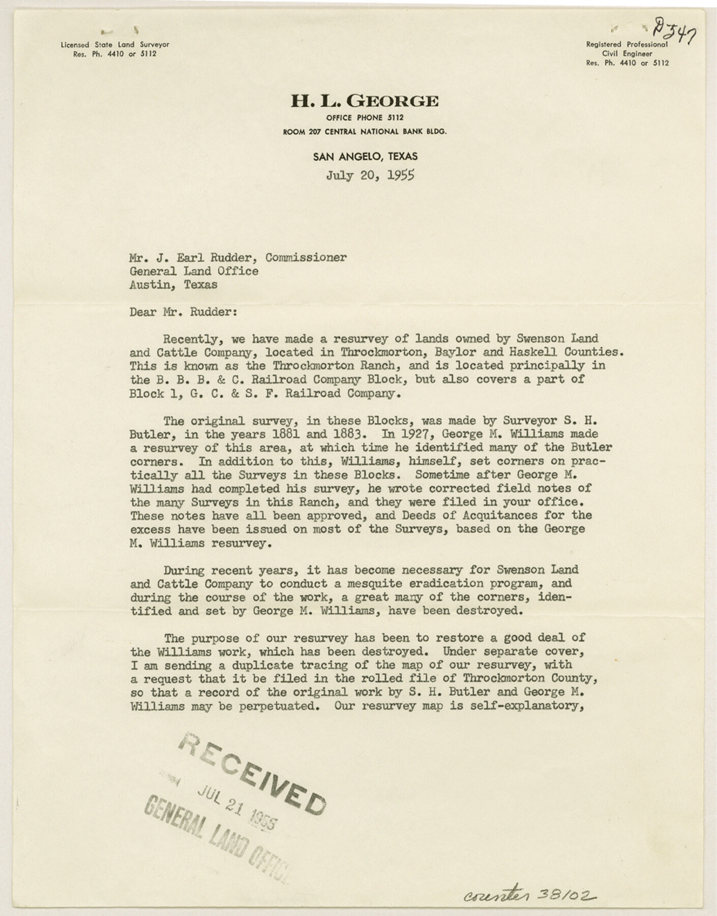
[Letter relating to resurvey of Swenson Land and Cattle Company lands]
-
Map/Doc
38102
-
Collection
General Map Collection
-
Object Dates
1955/7/20 (Creation Date)
1955/7/21 (File Date)
1955/7/20 (Correspondence Date)
1881 (Survey Date)
1883 (Survey Date)
1927 (Survey Date)
-
People and Organizations
Hugh L. George (Surveyor/Engineer)
S.H. Butler (Surveyor/Engineer)
George M. Williams (Surveyor/Engineer)
-
Counties
Throckmorton Baylor Haskell
-
Subjects
Surveying Sketch File
-
Height x Width
11.2 x 8.8 inches
28.4 x 22.4 cm
-
Medium
paper, print
-
Features
Throckmorton Ranch
Part of: General Map Collection
Dallas County Rolled Sketch 3A

Print $40.00
- Digital $50.00
Dallas County Rolled Sketch 3A
1953
Size 29.9 x 78.8 inches
Map/Doc 8768
Matagorda County Sketch File 40

Print $20.00
- Digital $50.00
Matagorda County Sketch File 40
Size 33.0 x 25.5 inches
Map/Doc 12048
Ward County Working Sketch 38

Print $40.00
- Digital $50.00
Ward County Working Sketch 38
1969
Size 62.2 x 30.3 inches
Map/Doc 72344
Rusk County Sketch File 43

Print $20.00
Rusk County Sketch File 43
1951
Size 23.5 x 26.6 inches
Map/Doc 12278
Val Verde County Rolled Sketch 72

Print $20.00
- Digital $50.00
Val Verde County Rolled Sketch 72
Size 15.2 x 28.5 inches
Map/Doc 8134
Val Verde County Sketch File 42

Print $20.00
- Digital $50.00
Val Verde County Sketch File 42
1939
Size 19.4 x 20.3 inches
Map/Doc 12584
Flight Mission No. DCL-7C, Frame 28, Kenedy County

Print $20.00
- Digital $50.00
Flight Mission No. DCL-7C, Frame 28, Kenedy County
1943
Size 15.4 x 15.4 inches
Map/Doc 86020
San Jacinto County Working Sketch 4

Print $20.00
- Digital $50.00
San Jacinto County Working Sketch 4
1934
Size 16.2 x 20.8 inches
Map/Doc 63717
Rains County Sketch File 9

Print $20.00
- Digital $50.00
Rains County Sketch File 9
Size 14.2 x 16.3 inches
Map/Doc 34960
Hidalgo County Working Sketch 5

Print $20.00
- Digital $50.00
Hidalgo County Working Sketch 5
1956
Size 38.1 x 37.9 inches
Map/Doc 66182
Victoria County Sketch File 5

Print $4.00
- Digital $50.00
Victoria County Sketch File 5
1877
Size 14.5 x 8.8 inches
Map/Doc 39520
Oldham County Boundary File 1a

Print $62.00
- Digital $50.00
Oldham County Boundary File 1a
Size 13.0 x 8.1 inches
Map/Doc 57734
You may also like
Galveston County Rolled Sketch 25

Print $20.00
- Digital $50.00
Galveston County Rolled Sketch 25
1965
Size 18.6 x 24.2 inches
Map/Doc 5961
Brown County Rolled Sketch 2C

Print $20.00
- Digital $50.00
Brown County Rolled Sketch 2C
1984
Size 26.7 x 24.6 inches
Map/Doc 5352
McCulloch County Working Sketch 18

Print $20.00
- Digital $50.00
McCulloch County Working Sketch 18
1997
Size 42.9 x 32.8 inches
Map/Doc 70693
[Sketch of part of Blks. B5, 6, 2Z, M6, M8, M11 and M15]
![89644, [Sketch of part of Blks. B5, 6, 2Z, M6, M8, M11 and M15], Twichell Survey Records](https://historictexasmaps.com/wmedia_w700/maps/89644-1.tif.jpg)
Print $40.00
- Digital $50.00
[Sketch of part of Blks. B5, 6, 2Z, M6, M8, M11 and M15]
Size 18.6 x 62.0 inches
Map/Doc 89644
Red River County Working Sketch 81-2

Print $20.00
- Digital $50.00
Red River County Working Sketch 81-2
1987
Size 14.6 x 18.6 inches
Map/Doc 72065
Calhoun County Rolled Sketch 8

Print $40.00
- Digital $50.00
Calhoun County Rolled Sketch 8
1921
Size 25.6 x 53.4 inches
Map/Doc 5364
Medina County Working Sketch 12

Print $20.00
- Digital $50.00
Medina County Working Sketch 12
1971
Size 24.2 x 23.9 inches
Map/Doc 70927
Polk County Working Sketch 23b

Print $40.00
- Digital $50.00
Polk County Working Sketch 23b
1957
Size 28.8 x 54.6 inches
Map/Doc 71639
Donley County Sketch File 9

Print $4.00
- Digital $50.00
Donley County Sketch File 9
1884
Size 6.6 x 7.7 inches
Map/Doc 21238
[Blocks T1, T2, T3, and Vicinity]
![90983, [Blocks T1, T2, T3, and Vicinity], Twichell Survey Records](https://historictexasmaps.com/wmedia_w700/maps/90983-1.tif.jpg)
Print $20.00
- Digital $50.00
[Blocks T1, T2, T3, and Vicinity]
Size 30.3 x 33.6 inches
Map/Doc 90983
Louisiana and Texas Intracoastal Waterway

Print $20.00
- Digital $50.00
Louisiana and Texas Intracoastal Waterway
Size 13.9 x 19.0 inches
Map/Doc 83347
Trinity County Sketch File 33A

Print $6.00
- Digital $50.00
Trinity County Sketch File 33A
1920
Size 6.5 x 6.8 inches
Map/Doc 38575