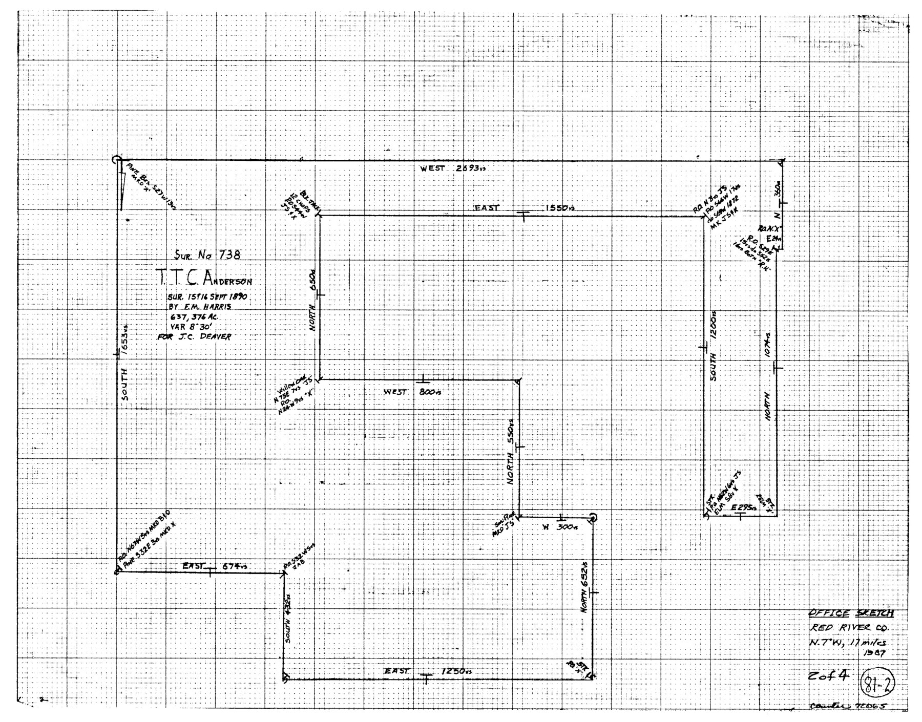
Red River County Working Sketch 81-2
-
Map/Doc
72065
-
Collection
General Map Collection
-
Object Dates
1987 (Creation Date)
-
Counties
Red River
-
Subjects
Surveying Working Sketch
-
Height x Width
14.6 x 18.6 inches
37.1 x 47.2 cm
Related maps
Red River County Working Sketch 81-1

Print $20.00
- Digital $50.00
Red River County Working Sketch 81-1
1987
Size 14.6 x 18.4 inches
Map/Doc 72064
Red River County Working Sketch 81-3

Print $20.00
- Digital $50.00
Red River County Working Sketch 81-3
1987
Size 17.5 x 21.5 inches
Map/Doc 72066
Red River County Working Sketch 81-4

Print $20.00
- Digital $50.00
Red River County Working Sketch 81-4
1987
Size 21.8 x 16.7 inches
Map/Doc 72067
Part of: General Map Collection
Township 10 South Range 13 West, South Western District, Louisiana

Print $20.00
- Digital $50.00
Township 10 South Range 13 West, South Western District, Louisiana
1876
Size 19.5 x 24.6 inches
Map/Doc 65853
Jefferson County Rolled Sketch 35

Print $20.00
- Digital $50.00
Jefferson County Rolled Sketch 35
1957
Size 37.9 x 26.0 inches
Map/Doc 6394
Red River, Levee Improvement Districts Widths of Floodways - Bois D'Arc Creek

Print $20.00
- Digital $50.00
Red River, Levee Improvement Districts Widths of Floodways - Bois D'Arc Creek
1921
Size 29.5 x 26.0 inches
Map/Doc 65271
Live Oak County Sketch File 31

Print $30.00
- Digital $50.00
Live Oak County Sketch File 31
1935
Size 36.0 x 32.5 inches
Map/Doc 10528

Denton County Sketch File 41

Print $6.00
- Digital $50.00
Denton County Sketch File 41
1883
Size 12.8 x 8.5 inches
Map/Doc 20789
Milam County Sketch File 2

Print $4.00
- Digital $50.00
Milam County Sketch File 2
1849
Size 8.0 x 12.4 inches
Map/Doc 31627

Starr County Working Sketch 4

Print $20.00
- Digital $50.00
Starr County Working Sketch 4
1927
Size 38.5 x 28.9 inches
Map/Doc 63920

Flight Mission No. DCL-7C, Frame 76, Kenedy County

Print $20.00
- Digital $50.00
Flight Mission No. DCL-7C, Frame 76, Kenedy County
1943
Size 15.4 x 15.1 inches
Map/Doc 86062
San Jacinto County Rolled Sketch 14

Print $20.00
- Digital $50.00
San Jacinto County Rolled Sketch 14
1998
Size 28.0 x 40.0 inches
Map/Doc 7565
You may also like
Medina County Sketch File 2

Print $12.00
- Digital $50.00
Medina County Sketch File 2
Size 7.5 x 12.5 inches
Map/Doc 31439
Jeff Davis County Rolled Sketch 19

Print $40.00
- Digital $50.00
Jeff Davis County Rolled Sketch 19
1885
Size 37.1 x 57.9 inches
Map/Doc 9265
Frio County Working Sketch 2

Print $20.00
- Digital $50.00
Frio County Working Sketch 2
1914
Size 17.9 x 15.1 inches
Map/Doc 69276
Dimmit County Sketch File 28

Print $40.00
- Digital $50.00
Dimmit County Sketch File 28
Size 14.7 x 17.4 inches
Map/Doc 11350
Crockett County Sketch File 57

Print $22.00
- Digital $50.00
Crockett County Sketch File 57
Size 12.2 x 8.9 inches
Map/Doc 19832

Flight Mission No. DQO-1K, Frame 115, Galveston County

Print $20.00
- Digital $50.00
Flight Mission No. DQO-1K, Frame 115, Galveston County
1952
Size 18.9 x 22.5 inches
Map/Doc 84993
Navigation Maps of Gulf Intracoastal Waterway, Port Arthur to Brownsville, Texas

Print $4.00
- Digital $50.00
Navigation Maps of Gulf Intracoastal Waterway, Port Arthur to Brownsville, Texas
1951
Size 16.6 x 21.5 inches
Map/Doc 65440
General Highway Map, Kleberg County, Texas

Print $20.00
General Highway Map, Kleberg County, Texas
1961
Size 24.6 x 18.3 inches
Map/Doc 79559
Flight Mission No. CRE-3R, Frame 39, Jackson County

Print $20.00
- Digital $50.00
Flight Mission No. CRE-3R, Frame 39, Jackson County
1956
Size 18.6 x 22.2 inches
Map/Doc 85386
Stonewall County Rolled Sketch 31

Print $20.00
- Digital $50.00
Stonewall County Rolled Sketch 31
1982
Size 25.6 x 42.9 inches
Map/Doc 7875
Flight Mission No. CLL-1N, Frame 182, Willacy County

Print $20.00
- Digital $50.00
Flight Mission No. CLL-1N, Frame 182, Willacy County
1954
Size 18.4 x 22.0 inches
Map/Doc 87052