Milam County Sketch File 2
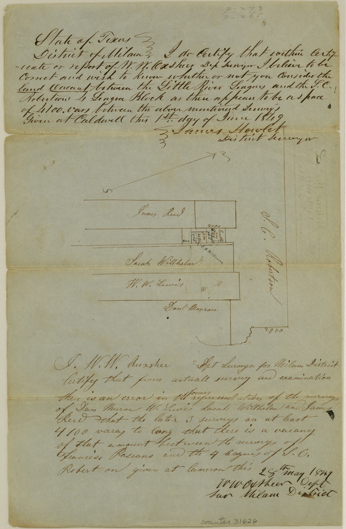
[Sketch of surveys northwest of the town of Cameron]
-
Map/Doc
31627
-
Collection
General Map Collection
-
Object Dates
6/1/1849 (Creation Date)
6/10/1849 (File Date)
-
People and Organizations
James Howlett (Surveyor/Engineer)
W.W. Oxsheer (Surveyor/Engineer)
-
Counties
Milam
-
Subjects
Surveying Sketch File
-
Height x Width
8.0 x 12.4 inches
20.3 x 31.5 cm
-
Medium
paper, manuscript
-
Features
Little River
[Cameron]
Part of: General Map Collection
Intracoastal Waterway in Texas - Corpus Christi to Point Isabel including Arroyo Colorado to Mo. Pac. R.R. Bridge Near Harlingen

Print $20.00
- Digital $50.00
Intracoastal Waterway in Texas - Corpus Christi to Point Isabel including Arroyo Colorado to Mo. Pac. R.R. Bridge Near Harlingen
1933
Size 28.0 x 41.0 inches
Map/Doc 61875
Flight Mission No. CGI-1N, Frame 144, Cameron County

Print $20.00
- Digital $50.00
Flight Mission No. CGI-1N, Frame 144, Cameron County
1955
Size 18.7 x 22.3 inches
Map/Doc 84500
Flight Mission No. DQN-2K, Frame 127, Calhoun County

Print $20.00
- Digital $50.00
Flight Mission No. DQN-2K, Frame 127, Calhoun County
1953
Size 18.4 x 22.3 inches
Map/Doc 84301

Presidio County Sketch File 68

Print $4.00
- Digital $50.00
Presidio County Sketch File 68
1941
Size 11.2 x 8.8 inches
Map/Doc 34662
Flight Mission No. CRK-5P, Frame 160, Refugio County

Print $20.00
- Digital $50.00
Flight Mission No. CRK-5P, Frame 160, Refugio County
1956
Size 18.6 x 22.4 inches
Map/Doc 86941
Travis County State Real Property Sketch 4

Print $20.00
- Digital $50.00
Travis County State Real Property Sketch 4
1987
Size 25.7 x 30.7 inches
Map/Doc 61695
Crockett County Sketch File 35d

Print $10.00
- Digital $50.00
Crockett County Sketch File 35d
Size 14.2 x 8.9 inches
Map/Doc 19750
Jackson County Sketch File 31

Print $18.00
- Digital $50.00
Jackson County Sketch File 31
1940
Size 14.4 x 8.4 inches
Map/Doc 27756
Val Verde County Working Sketch 113

Print $40.00
- Digital $50.00
Val Verde County Working Sketch 113
2003
Size 54.9 x 34.6 inches
Map/Doc 78492
Kinney County Working Sketch 36

Print $20.00
- Digital $50.00
Kinney County Working Sketch 36
1966
Size 31.7 x 42.0 inches
Map/Doc 70218
Jackson County Working Sketch 14

Print $20.00
- Digital $50.00
Jackson County Working Sketch 14
1990
Size 31.7 x 32.2 inches
Map/Doc 66462
You may also like
Culberson County Sketch File 15

Print $20.00
- Digital $50.00
Culberson County Sketch File 15
1933
Size 30.4 x 24.4 inches
Map/Doc 11267
Map of Mason County, Texas

Print $20.00
- Digital $50.00
Map of Mason County, Texas
Size 26.0 x 19.2 inches
Map/Doc 404
Garza County Sketch File 26a

Print $20.00
- Digital $50.00
Garza County Sketch File 26a
1915
Size 13.1 x 23.9 inches
Map/Doc 11547
Coast Chart No. 210 Aransas Pass and Corpus Christi Bay with the coast to latitude 27° 12' Texas

Print $20.00
- Digital $50.00
Coast Chart No. 210 Aransas Pass and Corpus Christi Bay with the coast to latitude 27° 12' Texas
1913
Size 27.9 x 18.3 inches
Map/Doc 72806
Chambers County Working Sketch 22

Print $20.00
- Digital $50.00
Chambers County Working Sketch 22
1978
Size 29.2 x 35.7 inches
Map/Doc 68005
Mason County Boundary File 63

Print $10.00
- Digital $50.00
Mason County Boundary File 63
Size 9.4 x 5.9 inches
Map/Doc 56879
Map Shelby County

Print $20.00
- Digital $50.00
Map Shelby County
1852
Size 20.1 x 31.5 inches
Map/Doc 4029
Roberts County Working Sketch 32

Print $20.00
- Digital $50.00
Roberts County Working Sketch 32
1978
Size 26.6 x 22.5 inches
Map/Doc 63558
Brewster County Rolled Sketch 88

Print $20.00
- Digital $50.00
Brewster County Rolled Sketch 88
1948
Size 23.7 x 19.7 inches
Map/Doc 5248
Palo Pinto County Sketch File A

Print $6.00
- Digital $50.00
Palo Pinto County Sketch File A
Size 8.7 x 4.1 inches
Map/Doc 33389
Galveston County NRC Article 33.136 Sketch 75

Print $32.00
- Digital $50.00
Galveston County NRC Article 33.136 Sketch 75
2014
Size 24.0 x 36.0 inches
Map/Doc 95118
Gaines County Sketch File 15

Print $5.00
- Digital $50.00
Gaines County Sketch File 15
1956
Size 11.6 x 8.8 inches
Map/Doc 23202