Culberson County Sketch File 15
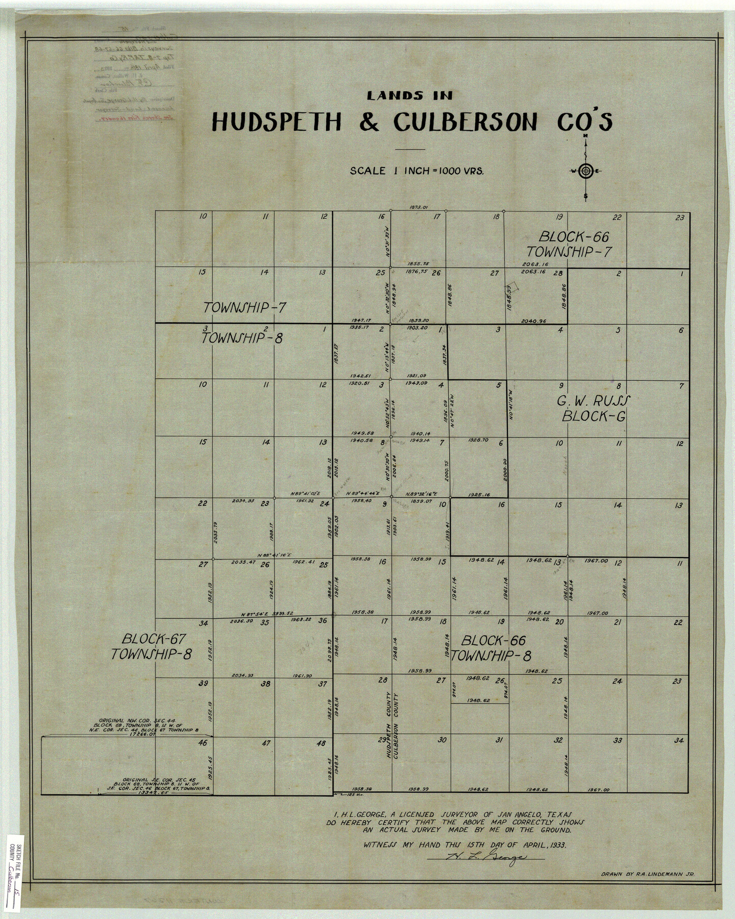
Lands in Hudspeth & Culberson Co's. - Surveys in Blks. 66-67-68, Tsp. 7-8 T.&P. Ry. Co.
-
Map/Doc
11267
-
Collection
General Map Collection
-
Object Dates
1933/4/15 (Creation Date)
1933/4/18 (File Date)
-
People and Organizations
H.L. George (Surveyor/Engineer)
R.A. Lindemann, Jr. (Draftsman)
-
Counties
Culberson Hudspeth
-
Subjects
Surveying Sketch File
-
Height x Width
30.4 x 24.4 inches
77.2 x 62.0 cm
-
Medium
paper, manuscript
Part of: General Map Collection
Duval County Rolled Sketch 11

Print $20.00
- Digital $50.00
Duval County Rolled Sketch 11
Size 20.4 x 30.1 inches
Map/Doc 5733
Zapata County Working Sketch 20

Print $20.00
- Digital $50.00
Zapata County Working Sketch 20
1979
Size 20.9 x 18.5 inches
Map/Doc 62071
Baylor County Sketch File A2

Print $4.00
- Digital $50.00
Baylor County Sketch File A2
1899
Size 10.4 x 8.2 inches
Map/Doc 14075
Wharton County Working Sketch 17

Print $20.00
- Digital $50.00
Wharton County Working Sketch 17
1951
Size 36.1 x 24.2 inches
Map/Doc 72481
Comal County Sketch File 15

Print $6.00
- Digital $50.00
Comal County Sketch File 15
Size 10.3 x 8.6 inches
Map/Doc 19031
Lubbock County

Print $20.00
- Digital $50.00
Lubbock County
1968
Size 43.5 x 35.4 inches
Map/Doc 77359
Matagorda County NRC Article 33.136 Sketch 10

Print $46.00
- Digital $50.00
Matagorda County NRC Article 33.136 Sketch 10
2013
Size 24.0 x 36.0 inches
Map/Doc 94519
Right of Way and Track Map Houston & Texas Central R.R. operated by the T. & N.O. R.R. Co., Austin Branch

Print $40.00
- Digital $50.00
Right of Way and Track Map Houston & Texas Central R.R. operated by the T. & N.O. R.R. Co., Austin Branch
1918
Size 25.8 x 57.8 inches
Map/Doc 64558
Matagorda County Working Sketch 14

Print $40.00
- Digital $50.00
Matagorda County Working Sketch 14
1950
Size 42.9 x 50.5 inches
Map/Doc 70872
Garza County Sketch File H1

Print $24.00
- Digital $50.00
Garza County Sketch File H1
Size 7.6 x 8.8 inches
Map/Doc 24030
El Paso County Rolled Sketch WL

Print $20.00
- Digital $50.00
El Paso County Rolled Sketch WL
1922
Size 26.9 x 19.1 inches
Map/Doc 5860
Red River County Working Sketch 22

Print $20.00
- Digital $50.00
Red River County Working Sketch 22
1955
Size 27.9 x 26.8 inches
Map/Doc 72005
You may also like
Irion County Rolled Sketch 25

Print $20.00
- Digital $50.00
Irion County Rolled Sketch 25
2008
Size 35.7 x 24.4 inches
Map/Doc 89227
![88993, San Jacinto Co[unty], Library of Congress](https://historictexasmaps.com/wmedia_w700/maps/88993.tif.jpg)
Stonewall County Working Sketch 19

Print $20.00
- Digital $50.00
Stonewall County Working Sketch 19
1957
Size 35.3 x 35.1 inches
Map/Doc 62326

Dickens County Rolled Sketch C

Print $20.00
- Digital $50.00
Dickens County Rolled Sketch C
1895
Size 20.5 x 25.5 inches
Map/Doc 5710
Terrell County Working Sketch 27

Print $20.00
- Digital $50.00
Terrell County Working Sketch 27
1944
Size 30.1 x 31.7 inches
Map/Doc 62177
[Map of Portion of Pecos County as Surveyed by F. F. Friend]
![91563, [Map of Portion of Pecos County as Surveyed by F. F. Friend], Twichell Survey Records](https://historictexasmaps.com/wmedia_w700/maps/91563-1.tif.jpg)
Print $20.00
- Digital $50.00
[Map of Portion of Pecos County as Surveyed by F. F. Friend]
1926
Size 17.3 x 13.9 inches
Map/Doc 91563
Garza County Sketch File C

Print $22.00
- Digital $50.00
Garza County Sketch File C
1900
Size 18.0 x 10.8 inches
Map/Doc 24013
Dimmit County Boundary File 6a

Print $6.00
- Digital $50.00
Dimmit County Boundary File 6a
Size 8.9 x 3.9 inches
Map/Doc 52587
[Sketch of State Capitol Leagues 615-621, 623-627, 177-209 in Lamb and Bailey Counties]
![89744, [Sketch of State Capitol Leagues 615-621, 623-627, 177-209 in Lamb and Bailey Counties], Twichell Survey Records](https://historictexasmaps.com/wmedia_w700/maps/89744-1.tif.jpg)
Print $40.00
- Digital $50.00
[Sketch of State Capitol Leagues 615-621, 623-627, 177-209 in Lamb and Bailey Counties]
1912
Size 71.2 x 31.5 inches
Map/Doc 89744
Cottle County Working Sketch 24

Print $20.00
- Digital $50.00
Cottle County Working Sketch 24
2014
Size 10.6 x 18.3 inches
Map/Doc 93707
Orange County Rolled Sketch 25

Print $20.00
- Digital $50.00
Orange County Rolled Sketch 25
1951
Size 29.0 x 43.5 inches
Map/Doc 10723