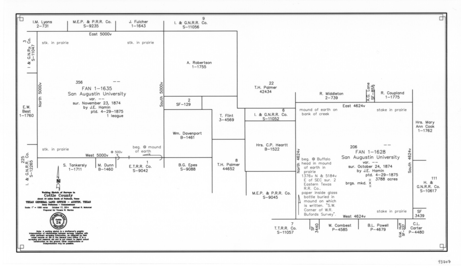
Cottle County Working Sketch 24
-
Map/Doc
93707
-
Collection
General Map Collection
-
Object Dates
10/17/2014 (Creation Date)
-
People and Organizations
Michael R. Mokarzel (Draftsman)
-
Counties
Cottle
-
Subjects
Surveying Working Sketch
-
Height x Width
10.6 x 18.3 inches
26.9 x 46.5 cm
-
Scale
1" = 1000 varas
Part of: General Map Collection
Nueces County Sketch File 12

Print $4.00
- Digital $50.00
Nueces County Sketch File 12
1848
Size 9.8 x 8.7 inches
Map/Doc 32528
Milam County Working Sketch 2

Print $20.00
- Digital $50.00
Milam County Working Sketch 2
1937
Size 20.2 x 20.5 inches
Map/Doc 71017
Roberts County Working Sketch 35

Print $20.00
- Digital $50.00
Roberts County Working Sketch 35
1978
Size 26.7 x 22.5 inches
Map/Doc 63561
University Lands Block 35 Crane & Ector Counties

Print $20.00
- Digital $50.00
University Lands Block 35 Crane & Ector Counties
1935
Size 40.2 x 46.7 inches
Map/Doc 2442
Potter County Sketch File 10

Print $40.00
- Digital $50.00
Potter County Sketch File 10
Size 58.9 x 37.7 inches
Map/Doc 10576
Bastrop County Rolled Sketch 1A

Print $20.00
- Digital $50.00
Bastrop County Rolled Sketch 1A
Size 37.0 x 24.5 inches
Map/Doc 5122
Flight Mission No. CLL-1N, Frame 77, Willacy County

Print $20.00
- Digital $50.00
Flight Mission No. CLL-1N, Frame 77, Willacy County
1954
Size 18.4 x 22.1 inches
Map/Doc 87023
Galveston Harbor and Channel, Texas Rehabilitation of South Jetty, Comparison of Shorelines and Offshore Contours 1890 to 1960

Print $20.00
- Digital $50.00
Galveston Harbor and Channel, Texas Rehabilitation of South Jetty, Comparison of Shorelines and Offshore Contours 1890 to 1960
1961
Size 31.6 x 41.8 inches
Map/Doc 61827
A new map for travellers through the United States of America showing the railroads, canals & stageroads with the distances

Print $20.00
- Digital $50.00
A new map for travellers through the United States of America showing the railroads, canals & stageroads with the distances
1846
Size 22.4 x 27.9 inches
Map/Doc 95921
Newton County Rolled Sketch 6

Print $20.00
- Digital $50.00
Newton County Rolled Sketch 6
Size 24.9 x 45.7 inches
Map/Doc 6842
Controlled Mosaic by Jack Amman Photogrammetric Engineers, Inc - Sheet 12

Print $20.00
- Digital $50.00
Controlled Mosaic by Jack Amman Photogrammetric Engineers, Inc - Sheet 12
1954
Size 20.0 x 24.0 inches
Map/Doc 83456
Cherokee County Sketch File 28

Print $6.00
- Digital $50.00
Cherokee County Sketch File 28
1916
Size 11.0 x 14.0 inches
Map/Doc 18173
You may also like
Tom Green County Sketch File 65

Print $18.00
- Digital $50.00
Tom Green County Sketch File 65
1892
Size 13.3 x 8.4 inches
Map/Doc 38227
Pecos County Rolled Sketch 181

Print $20.00
- Digital $50.00
Pecos County Rolled Sketch 181
1980
Size 18.4 x 18.7 inches
Map/Doc 7300
[Surveys Along Canadian River]
![92359, [Surveys Along Canadian River], Twichell Survey Records](https://historictexasmaps.com/wmedia_w700/maps/92359-1.tif.jpg)
Print $20.00
- Digital $50.00
[Surveys Along Canadian River]
Size 42.9 x 27.0 inches
Map/Doc 92359
Latest Map of the State of Texas

Print $20.00
Latest Map of the State of Texas
1888
Size 30.7 x 32.9 inches
Map/Doc 79747
Cooke County Working Sketch 7

Print $20.00
- Digital $50.00
Cooke County Working Sketch 7
1939
Size 25.1 x 33.7 inches
Map/Doc 68244

Brewster County Working Sketch 2

Print $20.00
- Digital $50.00
Brewster County Working Sketch 2
1907
Size 29.0 x 26.4 inches
Map/Doc 67535
Cameron County Rolled Sketch Z2

Print $20.00
- Digital $50.00
Cameron County Rolled Sketch Z2
1937
Size 23.7 x 40.9 inches
Map/Doc 5402
Colorado River, Hungerford Sheet

Print $6.00
- Digital $50.00
Colorado River, Hungerford Sheet
1941
Size 24.1 x 35.4 inches
Map/Doc 65309
Hays County Sketch File 3

Print $4.00
- Digital $50.00
Hays County Sketch File 3
1846
Size 7.1 x 8.2 inches
Map/Doc 26202
Jefferson County Rolled Sketch 67

Print $20.00
- Digital $50.00
Jefferson County Rolled Sketch 67
2007
Size 21.1 x 23.6 inches
Map/Doc 93426
Asher & Adams' Geological Map - United States and Territories

Print $20.00
- Digital $50.00
Asher & Adams' Geological Map - United States and Territories
1874
Size 17.9 x 24.9 inches
Map/Doc 95175