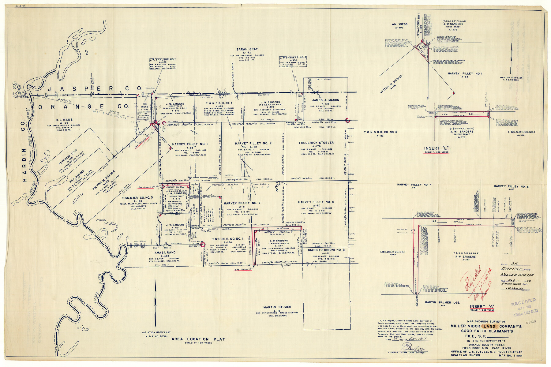
Orange County Rolled Sketch 25
Map showing survey of Miller Vidor Land Company's Good Faith Claimant's file in the northwest part Orange County, Texas
-
Map/Doc
10723
-
Collection
General Map Collection
-
Object Dates
12/17/1951 (Creation Date)
2/7/1952 (File Date)
-
People and Organizations
J.S. Boyles (Surveyor/Engineer)
-
Counties
Orange
-
Subjects
Surveying Rolled Sketch
-
Height x Width
29.0 x 43.5 inches
73.7 x 110.5 cm
-
Medium
blueprint/diazo
-
Comments
See Scrap Files 15329, 15330, and 15331.
Part of: General Map Collection
Somervell County Working Sketch 6

Print $20.00
- Digital $50.00
Somervell County Working Sketch 6
1992
Size 23.2 x 21.5 inches
Map/Doc 63910
Nautical Chart 892-SC - Intracoastal Waterway - Carlos Bay to Redfish Bay including Copano Bay, Texas

Print $20.00
- Digital $50.00
Nautical Chart 892-SC - Intracoastal Waterway - Carlos Bay to Redfish Bay including Copano Bay, Texas
1972
Size 16.0 x 18.7 inches
Map/Doc 75912
Robertson County Sketch File 9

Print $68.00
Robertson County Sketch File 9
1846
Size 10.2 x 8.3 inches
Map/Doc 35366
Kaufman County Boundary File 3

Print $14.00
- Digital $50.00
Kaufman County Boundary File 3
Size 12.7 x 8.2 inches
Map/Doc 55922
Flight Mission No. BRA-6M, Frame 98, Jefferson County

Print $20.00
- Digital $50.00
Flight Mission No. BRA-6M, Frame 98, Jefferson County
1953
Size 18.5 x 22.2 inches
Map/Doc 85441
Flight Mission No. CRC-5R, Frame 41, Chambers County

Print $20.00
- Digital $50.00
Flight Mission No. CRC-5R, Frame 41, Chambers County
1956
Size 18.7 x 22.3 inches
Map/Doc 84960
Travis County Sketch File 2

Print $4.00
- Digital $50.00
Travis County Sketch File 2
1851
Size 8.2 x 9.9 inches
Map/Doc 38271
Zapata County Rolled Sketch 9

Print $20.00
- Digital $50.00
Zapata County Rolled Sketch 9
1912
Size 15.0 x 15.5 inches
Map/Doc 8310
Floyd County Working Sketch 5

Print $20.00
- Digital $50.00
Floyd County Working Sketch 5
1955
Size 33.3 x 23.6 inches
Map/Doc 69184
Map of Cherokee County

Print $40.00
- Digital $50.00
Map of Cherokee County
1933
Size 55.0 x 38.7 inches
Map/Doc 95453
Flight Mission No. DQN-5K, Frame 49, Calhoun County

Print $20.00
- Digital $50.00
Flight Mission No. DQN-5K, Frame 49, Calhoun County
1953
Size 17.4 x 22.3 inches
Map/Doc 84394
Part of Laguna Madre from Mosquito Trangulation Station to Sand Triangulation Station

Print $40.00
- Digital $50.00
Part of Laguna Madre from Mosquito Trangulation Station to Sand Triangulation Station
1881
Size 34.5 x 54.6 inches
Map/Doc 73486
You may also like
Jeff Davis County Working Sketch 43

Print $20.00
- Digital $50.00
Jeff Davis County Working Sketch 43
1983
Size 37.2 x 47.0 inches
Map/Doc 66538
Wise County Sketch File 31

Print $12.00
- Digital $50.00
Wise County Sketch File 31
1877
Size 13.1 x 8.1 inches
Map/Doc 40582
Map of Gregg County

Print $20.00
- Digital $50.00
Map of Gregg County
1874
Size 14.0 x 13.9 inches
Map/Doc 3604
Map of North Meadow Located on S. Part SE 1/4 Section

Print $20.00
- Digital $50.00
Map of North Meadow Located on S. Part SE 1/4 Section
Size 11.6 x 21.0 inches
Map/Doc 92284
Culberson Co.

Print $20.00
- Digital $50.00
Culberson Co.
1943
Size 41.2 x 25.5 inches
Map/Doc 77256
Kendall County Sketch File 9

Print $6.00
- Digital $50.00
Kendall County Sketch File 9
1879
Size 4.6 x 9.3 inches
Map/Doc 28692
Mason County Working Sketch 1

Print $3.00
- Digital $50.00
Mason County Working Sketch 1
Size 10.7 x 16.2 inches
Map/Doc 70837
Crockett County Rolled Sketch 62

Print $20.00
- Digital $50.00
Crockett County Rolled Sketch 62
1947
Size 27.0 x 38.1 inches
Map/Doc 5605
Flight Mission No. DAH-9M, Frame 88, Orange County

Print $20.00
- Digital $50.00
Flight Mission No. DAH-9M, Frame 88, Orange County
1953
Size 18.5 x 22.6 inches
Map/Doc 86852
Dimmit County Working Sketch 16

Print $20.00
- Digital $50.00
Dimmit County Working Sketch 16
1943
Size 25.6 x 24.8 inches
Map/Doc 68677
Map exhibiting the lines of march passed over by the troops of the United States during the year ending June 30th, 1858 prepared by order of the Hon. J.B. Floyd, Sec. War.

Print $20.00
- Digital $50.00
Map exhibiting the lines of march passed over by the troops of the United States during the year ending June 30th, 1858 prepared by order of the Hon. J.B. Floyd, Sec. War.
1858
Size 20.0 x 20.3 inches
Map/Doc 94079
Dimmit County Sketch File 9a

Print $4.00
- Digital $50.00
Dimmit County Sketch File 9a
Size 12.7 x 8.2 inches
Map/Doc 21073