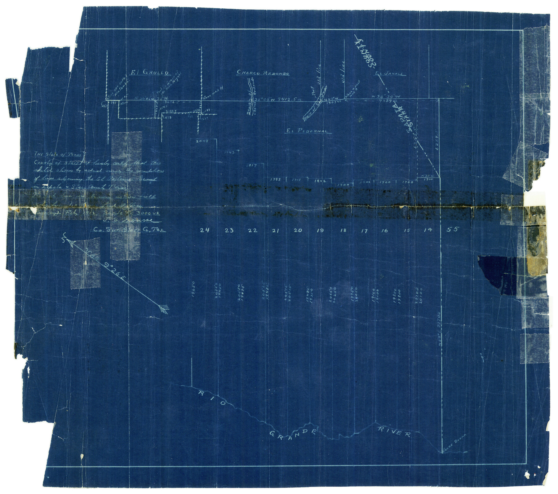
Zapata County Rolled Sketch 9
[Sketch of Porciones 14-24 along Rio Grande and surrounding area]
-
Map/Doc
8310
-
Collection
General Map Collection
-
Object Dates
2/1912 (Creation Date)
-
People and Organizations
J.S. Monroe (Surveyor/Engineer)
-
Counties
Zapata
-
Subjects
Surveying Rolled Sketch
-
Height x Width
15.0 x 15.5 inches
38.1 x 39.4 cm
-
Medium
blueprint/diazo
-
Scale
1" = 3000 varas
Part of: General Map Collection
Duval County Working Sketch 22

Print $20.00
- Digital $50.00
Duval County Working Sketch 22
1942
Size 21.9 x 26.0 inches
Map/Doc 68746
Brazos Santiago, Texas

Print $20.00
- Digital $50.00
Brazos Santiago, Texas
1867
Size 25.6 x 18.2 inches
Map/Doc 72989
Chambers County Rolled Sketch 22

Print $20.00
- Digital $50.00
Chambers County Rolled Sketch 22
1940
Size 24.9 x 38.9 inches
Map/Doc 5427
Dickens County Sketch File 6a

Print $6.00
- Digital $50.00
Dickens County Sketch File 6a
1882
Size 16.5 x 9.4 inches
Map/Doc 20969
Gonzales County Sketch File 11

Print $4.00
- Digital $50.00
Gonzales County Sketch File 11
1842
Size 12.8 x 7.9 inches
Map/Doc 24392
Ochiltree County Rolled Sketch 1

Print $20.00
- Digital $50.00
Ochiltree County Rolled Sketch 1
1942
Size 29.3 x 38.8 inches
Map/Doc 9655
Kimble County Sketch File 6

Print $4.00
- Digital $50.00
Kimble County Sketch File 6
Size 6.4 x 8.0 inches
Map/Doc 28918
Limestone County Working Sketch 11

Print $20.00
- Digital $50.00
Limestone County Working Sketch 11
1922
Size 36.1 x 33.9 inches
Map/Doc 70561
Hutchinson County Rolled Sketch 44-5

Print $20.00
- Digital $50.00
Hutchinson County Rolled Sketch 44-5
2002
Size 24.0 x 36.0 inches
Map/Doc 77541
[Surveys near Onion Creek]
![108, [Surveys near Onion Creek], General Map Collection](https://historictexasmaps.com/wmedia_w700/maps/108-1.tif.jpg)
Print $2.00
- Digital $50.00
[Surveys near Onion Creek]
1841
Size 11.0 x 7.8 inches
Map/Doc 108
Flight Mission No. DCL-7C, Frame 138, Kenedy County

Print $20.00
- Digital $50.00
Flight Mission No. DCL-7C, Frame 138, Kenedy County
1943
Size 18.6 x 22.3 inches
Map/Doc 86095
Real County Working Sketch Graphic Index, Sheet 1 (Sketches 1 to 42)

Print $20.00
- Digital $50.00
Real County Working Sketch Graphic Index, Sheet 1 (Sketches 1 to 42)
1972
Size 42.9 x 31.0 inches
Map/Doc 76678
You may also like
[Northwest Garza County around John Walker and Thomas Hughes surveys]
![90906, [Northwest Garza County around John Walker and Thomas Hughes surveys], Twichell Survey Records](https://historictexasmaps.com/wmedia_w700/maps/90906-1.tif.jpg)
Print $20.00
- Digital $50.00
[Northwest Garza County around John Walker and Thomas Hughes surveys]
1913
Size 28.3 x 14.5 inches
Map/Doc 90906
Brewster County Sketch File 48

Print $4.00
- Digital $50.00
Brewster County Sketch File 48
1940
Size 11.4 x 9.2 inches
Map/Doc 16327
![92466, [Muleshoe], Twichell Survey Records](https://historictexasmaps.com/wmedia_w700/maps/92466-1.tif.jpg)
Tom Green County Sketch File 68

Print $20.00
- Digital $50.00
Tom Green County Sketch File 68
1913
Size 30.8 x 41.5 inches
Map/Doc 10406
Val Verde County Working Sketch 1

Print $40.00
- Digital $50.00
Val Verde County Working Sketch 1
Size 34.8 x 58.2 inches
Map/Doc 72136
Map of section no. 12 of a survey of Padre Island made for the Office of the Attorney General of the State of Texas

Print $40.00
- Digital $50.00
Map of section no. 12 of a survey of Padre Island made for the Office of the Attorney General of the State of Texas
1941
Size 75.9 x 41.0 inches
Map/Doc 2268
Map of a resurvey of the land involved in the suit of Lillian-Vineyard vs. O.M. O'Connor et al (Lamar townlots excepted)

Print $20.00
- Digital $50.00
Map of a resurvey of the land involved in the suit of Lillian-Vineyard vs. O.M. O'Connor et al (Lamar townlots excepted)
1911
Size 18.8 x 17.9 inches
Map/Doc 481
Perspective Map of Texarkana, Texas and Arkansas

Print $20.00
Perspective Map of Texarkana, Texas and Arkansas
1888
Size 18.1 x 29.2 inches
Map/Doc 93485
Sherman County Sketch File D

Print $5.00
- Digital $50.00
Sherman County Sketch File D
1959
Size 10.6 x 8.9 inches
Map/Doc 36721
[Map Showing Fence Line between Blocks XIT and LS]
![91408, [Map Showing Fence Line between Blocks XIT and LS], Twichell Survey Records](https://historictexasmaps.com/wmedia_w700/maps/91408-1.tif.jpg)
Print $20.00
- Digital $50.00
[Map Showing Fence Line between Blocks XIT and LS]
1886
Size 18.4 x 16.7 inches
Map/Doc 91408
Scurry County Rolled Sketch 12

Print $20.00
- Digital $50.00
Scurry County Rolled Sketch 12
1983
Size 27.7 x 27.0 inches
Map/Doc 7772
Blanco County Working Sketch 31

Print $20.00
- Digital $50.00
Blanco County Working Sketch 31
1972
Size 19.1 x 25.7 inches
Map/Doc 67391