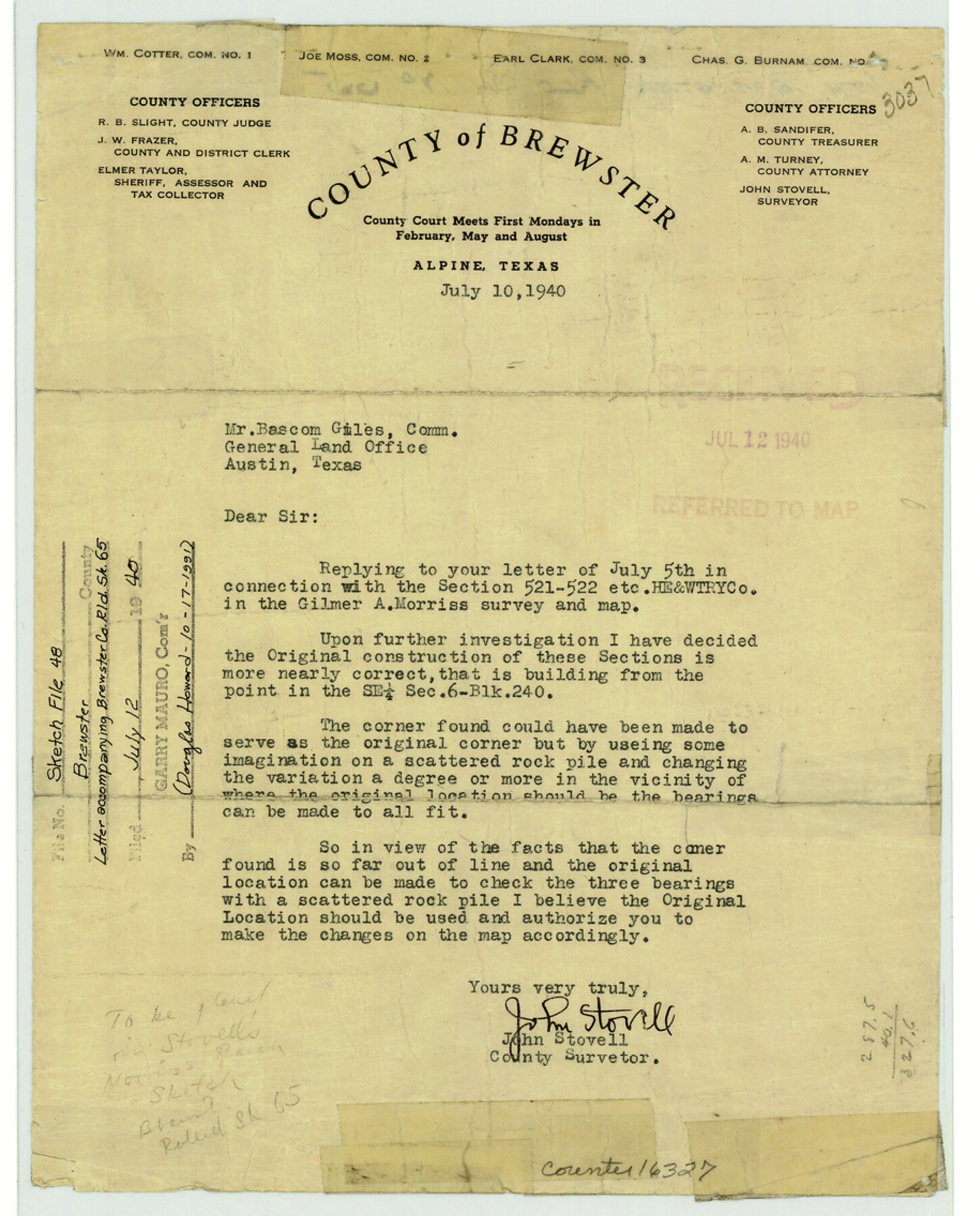
Brewster County Sketch File 48
[Letter regarding Morriss Ranch, Blocks 233, 234, 239 and 240 and adjoining area]
-
Map/Doc
16327
-
Collection
General Map Collection
-
Object Dates
1940/7/10 (Creation Date)
1940/7/12 (File Date)
-
People and Organizations
John Stovell (Surveyor/Engineer)
-
Counties
Brewster
-
Subjects
Surveying Sketch File
-
Height x Width
11.4 x 9.2 inches
29.0 x 23.4 cm
-
Medium
paper, print
-
Comments
See Brewster County Rolled Sketch 65 (8489) for sketch.
Related maps
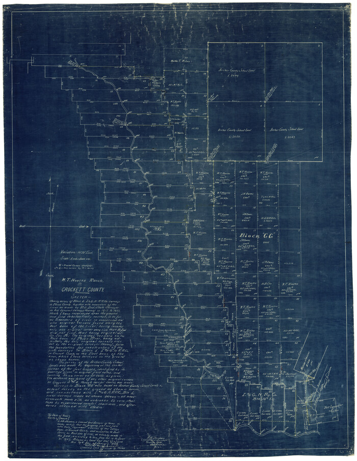
Brewster County Rolled Sketch 65

Print $40.00
- Digital $50.00
Brewster County Rolled Sketch 65
1940
Size 57.0 x 38.8 inches
Map/Doc 8489
Part of: General Map Collection
Jim Hogg County Working Sketch 9

Print $20.00
- Digital $50.00
Jim Hogg County Working Sketch 9
1973
Size 14.3 x 11.2 inches
Map/Doc 66595
Webb County Working Sketch 18

Print $20.00
- Digital $50.00
Webb County Working Sketch 18
1923
Size 18.6 x 12.8 inches
Map/Doc 72383
Sketch of coast of Texas, Laguna Madre from Pt. of Rocks to Corpus Christi [and accompanying letter]
![72964, Sketch of coast of Texas, Laguna Madre from Pt. of Rocks to Corpus Christi [and accompanying letter], General Map Collection](https://historictexasmaps.com/wmedia_w700/maps/72964.tif.jpg)
Print $2.00
- Digital $50.00
Sketch of coast of Texas, Laguna Madre from Pt. of Rocks to Corpus Christi [and accompanying letter]
Size 11.2 x 8.8 inches
Map/Doc 72964
Red River County Working Sketch 35

Print $20.00
- Digital $50.00
Red River County Working Sketch 35
1964
Size 34.9 x 41.0 inches
Map/Doc 72018
Trinity River, Clapps Ferry Sheet

Print $20.00
- Digital $50.00
Trinity River, Clapps Ferry Sheet
1925
Size 47.5 x 36.4 inches
Map/Doc 65180
Rachford's Complete Map of the City of Beaumont

Print $20.00
- Digital $50.00
Rachford's Complete Map of the City of Beaumont
1897
Size 33.4 x 23.6 inches
Map/Doc 97355
Travis County Appraisal District Plat Map 2_2915

Print $20.00
- Digital $50.00
Travis County Appraisal District Plat Map 2_2915
Size 21.5 x 26.4 inches
Map/Doc 94219
Panola County Sketch File 25

Print $20.00
- Digital $50.00
Panola County Sketch File 25
1946
Size 24.1 x 21.4 inches
Map/Doc 12140
Sketch Showing surveys on Harbor Island in Nueces County

Print $20.00
- Digital $50.00
Sketch Showing surveys on Harbor Island in Nueces County
1951
Size 45.7 x 34.6 inches
Map/Doc 1915
Eastland County Working Sketch 22

Print $20.00
- Digital $50.00
Eastland County Working Sketch 22
1920
Size 19.9 x 19.2 inches
Map/Doc 68803
Bandera County Working Sketch 42

Print $20.00
- Digital $50.00
Bandera County Working Sketch 42
1978
Size 26.9 x 29.8 inches
Map/Doc 67638
Travis County Working Sketch 48

Print $40.00
- Digital $50.00
Travis County Working Sketch 48
1981
Size 53.7 x 40.3 inches
Map/Doc 69432
You may also like
Map of Montague County

Print $20.00
- Digital $50.00
Map of Montague County
1858
Size 28.6 x 20.5 inches
Map/Doc 3886
Pecos County Sketch File 101

Print $40.00
- Digital $50.00
Pecos County Sketch File 101
1960
Size 15.6 x 11.7 inches
Map/Doc 34012
Crockett County Rolled Sketch CP
Print $20.00
- Digital $50.00
Crockett County Rolled Sketch CP
1928
Size 39.9 x 30.8 inches
Map/Doc 8695
Nueces River, La Fruta Sheet

Print $20.00
- Digital $50.00
Nueces River, La Fruta Sheet
1927
Size 36.4 x 37.2 inches
Map/Doc 65089
Mills County Sketch File 25

Print $8.00
- Digital $50.00
Mills County Sketch File 25
1949
Size 11.3 x 8.8 inches
Map/Doc 31674

[Portion of Harrison County]
![78366, [Portion of Harrison County], General Map Collection](https://historictexasmaps.com/wmedia_w700/maps/78366.tif.jpg)
Print $3.00
- Digital $50.00
[Portion of Harrison County]
1841
Size 15.7 x 11.6 inches
Map/Doc 78366
Falls County Sketch File 18

Print $4.00
- Digital $50.00
Falls County Sketch File 18
Size 10.3 x 8.2 inches
Map/Doc 22380
Ward County Working Sketch 42

Print $20.00
- Digital $50.00
Ward County Working Sketch 42
1970
Size 42.2 x 41.3 inches
Map/Doc 72348
[Texas Boundary Line]
![92080, [Texas Boundary Line], Twichell Survey Records](https://historictexasmaps.com/wmedia_w700/maps/92080-1.tif.jpg)
Print $20.00
- Digital $50.00
[Texas Boundary Line]
Size 21.7 x 12.1 inches
Map/Doc 92080
Liberty County Sketch File 38

Print $22.00
- Digital $50.00
Liberty County Sketch File 38
1899
Size 13.9 x 8.9 inches
Map/Doc 29983
Dallas County Rolled Sketch 1

Print $40.00
- Digital $50.00
Dallas County Rolled Sketch 1
1938
Size 22.7 x 78.5 inches
Map/Doc 8765