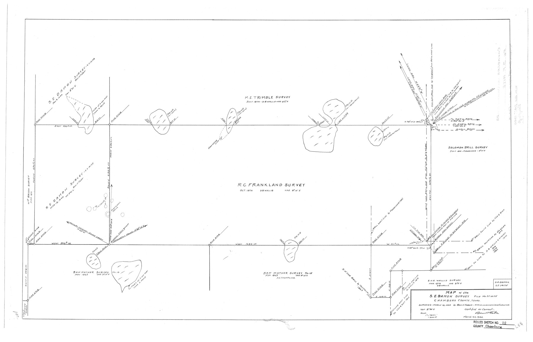
Chambers County Rolled Sketch 22
Map of the S.E. Damon survey file no. SF-14175, Chambers County, Texas
-
Map/Doc
5427
-
Collection
General Map Collection
-
Object Dates
1940/3/18 (Survey Date)
1940/4/24 (File Date)
1940/3/20 (Creation Date)
-
People and Organizations
Ben H. Faber (Surveyor/Engineer)
-
Counties
Chambers
-
Subjects
Surveying Rolled Sketch
-
Height x Width
24.9 x 38.9 inches
63.2 x 98.8 cm
-
Scale
1" = 72 varas = 200 ft.
Part of: General Map Collection

Yoakum County Sketch File 6

Print $24.00
- Digital $50.00
Yoakum County Sketch File 6
Size 14.5 x 8.8 inches
Map/Doc 40738
Railroad Track Map, H&TCRRCo., Falls County, Texas

Print $4.00
- Digital $50.00
Railroad Track Map, H&TCRRCo., Falls County, Texas
1918
Size 11.6 x 18.6 inches
Map/Doc 62834
Coryell County Working Sketch 9

Print $20.00
- Digital $50.00
Coryell County Working Sketch 9
1947
Size 28.7 x 30.0 inches
Map/Doc 68216
Starr County Sketch File 18

Print $20.00
- Digital $50.00
Starr County Sketch File 18
1880
Size 38.2 x 25.1 inches
Map/Doc 10606
Wise County Sketch File 9

Print $5.00
- Digital $50.00
Wise County Sketch File 9
1854
Size 11.9 x 14.8 inches
Map/Doc 40539
Johnson County Sketch File 11

Print $8.00
- Digital $50.00
Johnson County Sketch File 11
1880
Size 8.0 x 6.8 inches
Map/Doc 28447
Cameron County Sketch File 6

Print $20.00
- Digital $50.00
Cameron County Sketch File 6
1970
Size 11.0 x 8.5 inches
Map/Doc 17032
Cottle County Working Sketch 9

Print $20.00
- Digital $50.00
Cottle County Working Sketch 9
1919
Size 33.3 x 32.1 inches
Map/Doc 68319
Wheeler County Working Sketch 12

Print $40.00
- Digital $50.00
Wheeler County Working Sketch 12
1978
Size 38.5 x 51.1 inches
Map/Doc 72501
Right of Way and Track Map International & Gt. Northern Ry. operated by the International & Gt. Northern Ry. Co., Gulf Division, Columbia Branch

Print $40.00
- Digital $50.00
Right of Way and Track Map International & Gt. Northern Ry. operated by the International & Gt. Northern Ry. Co., Gulf Division, Columbia Branch
1917
Size 25.1 x 57.0 inches
Map/Doc 64600
Montague County Working Sketch 38

Print $20.00
- Digital $50.00
Montague County Working Sketch 38
1990
Size 14.9 x 15.6 inches
Map/Doc 71104
You may also like
Red River County Working Sketch 32

Print $20.00
- Digital $50.00
Red River County Working Sketch 32
1962
Size 27.6 x 20.0 inches
Map/Doc 72015
Kleberg County Aerial Photograph Index Sheet 6

Print $20.00
- Digital $50.00
Kleberg County Aerial Photograph Index Sheet 6
1956
Size 19.3 x 23.5 inches
Map/Doc 83723
Houston County Sketch File 34

Print $6.00
- Digital $50.00
Houston County Sketch File 34
1914
Size 13.3 x 11.0 inches
Map/Doc 26811
Flight Mission No. CGN-3P, Frame 24, San Patricio County

Print $20.00
- Digital $50.00
Flight Mission No. CGN-3P, Frame 24, San Patricio County
1956
Size 18.5 x 22.3 inches
Map/Doc 86982
Flight Mission No. DQO-8K, Frame 54, Galveston County

Print $20.00
- Digital $50.00
Flight Mission No. DQO-8K, Frame 54, Galveston County
1952
Size 18.5 x 22.2 inches
Map/Doc 85161
Flight Mission No. DQO-8K, Frame 6, Galveston County

Print $20.00
- Digital $50.00
Flight Mission No. DQO-8K, Frame 6, Galveston County
1952
Size 18.8 x 22.3 inches
Map/Doc 85129
Camp County Working Sketch Graphic Index

Print $20.00
- Digital $50.00
Camp County Working Sketch Graphic Index
1942
Size 25.1 x 29.7 inches
Map/Doc 76487
Blanco County Sketch File 1

Print $4.00
- Digital $50.00
Blanco County Sketch File 1
1874
Size 7.8 x 7.9 inches
Map/Doc 14578
Sulphur River and Cuthand Creek, Hardison Lake Sheet

Print $20.00
- Digital $50.00
Sulphur River and Cuthand Creek, Hardison Lake Sheet
1919
Size 13.4 x 18.0 inches
Map/Doc 78327
[Sketch of Potter County Road, North of River]
![93059, [Sketch of Potter County Road, North of River], Twichell Survey Records](https://historictexasmaps.com/wmedia_w700/maps/93059-1.tif.jpg)
Print $20.00
- Digital $50.00
[Sketch of Potter County Road, North of River]
Size 12.5 x 29.5 inches
Map/Doc 93059
Presidio County Rolled Sketch 145

Print $20.00
- Digital $50.00
Presidio County Rolled Sketch 145
2012
Size 36.6 x 24.5 inches
Map/Doc 93380
Map of Moser Ranch, Bowie County, Texas

Print $20.00
- Digital $50.00
Map of Moser Ranch, Bowie County, Texas
Size 29.0 x 27.4 inches
Map/Doc 73558