Jackson County Sketch File 31
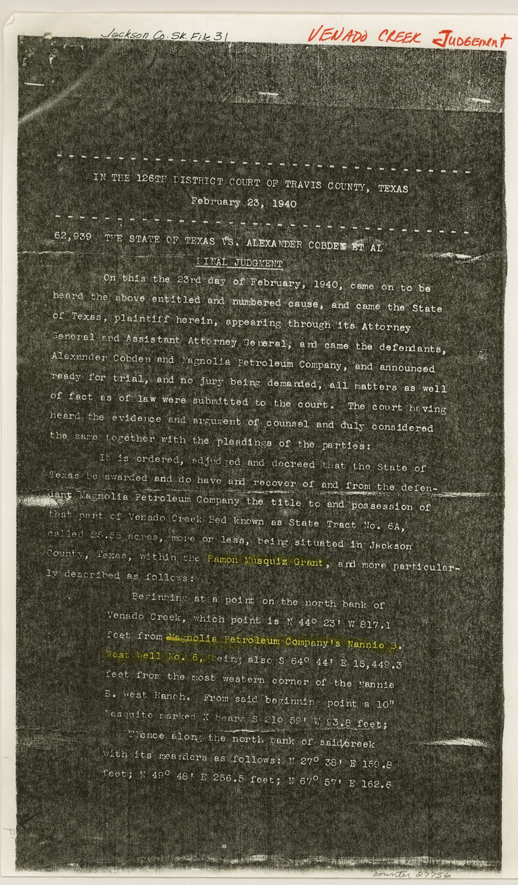
[Venado Creek Judgement - State of Texas vs. Alexander Cobden, et al]
-
Map/Doc
27756
-
Collection
General Map Collection
-
Object Dates
1940/2/23 (Creation Date)
1991/10/25 (File Date)
-
People and Organizations
126th District Court, Travis County (Surveyor/Engineer)
-
Counties
Jackson
-
Subjects
Surveying Sketch File
-
Height x Width
14.4 x 8.4 inches
36.6 x 21.3 cm
-
Medium
photostat, negative
-
Features
Venado Creek
Part of: General Map Collection
Hunt County Working Sketch 2

Print $20.00
- Digital $50.00
Hunt County Working Sketch 2
Size 20.5 x 16.5 inches
Map/Doc 66349
Hill County Sketch File 1

Print $4.00
- Digital $50.00
Hill County Sketch File 1
1857
Size 9.0 x 7.9 inches
Map/Doc 26459
Baylor County Sketch File 27

Print $4.00
- Digital $50.00
Baylor County Sketch File 27
1895
Size 11.1 x 8.9 inches
Map/Doc 14226
Coryell County Working Sketch 9

Print $20.00
- Digital $50.00
Coryell County Working Sketch 9
1947
Size 28.7 x 30.0 inches
Map/Doc 68216
Florida et Apalche

Print $20.00
- Digital $50.00
Florida et Apalche
1597
Size 11.2 x 14.4 inches
Map/Doc 94076
Flight Mission No. DAG-24K, Frame 128, Matagorda County

Print $20.00
- Digital $50.00
Flight Mission No. DAG-24K, Frame 128, Matagorda County
1953
Size 17.2 x 22.5 inches
Map/Doc 86546
Presidio County Sketch File 54

Print $4.00
- Digital $50.00
Presidio County Sketch File 54
Size 14.3 x 8.8 inches
Map/Doc 34620
Upton County Sketch File 26

Print $20.00
- Digital $50.00
Upton County Sketch File 26
1928
Size 22.6 x 14.2 inches
Map/Doc 12520
Limestone County Working Sketch 5

Print $20.00
- Digital $50.00
Limestone County Working Sketch 5
1922
Size 21.2 x 28.9 inches
Map/Doc 70555
Randall County Rolled Sketch 1

Print $20.00
- Digital $50.00
Randall County Rolled Sketch 1
1889
Size 21.1 x 35.1 inches
Map/Doc 9807
Presidio County Sketch File 122

Print $22.00
- Digital $50.00
Presidio County Sketch File 122
2010
Size 11.0 x 8.5 inches
Map/Doc 89604
Runnels County Sketch File 41

Print $20.00
Runnels County Sketch File 41
1892
Size 22.8 x 25.7 inches
Map/Doc 12271
You may also like
Limestone County, 1922

Print $40.00
- Digital $50.00
Limestone County, 1922
1922
Size 36.4 x 50.1 inches
Map/Doc 89704
Trinity County Working Sketch 17

Print $20.00
- Digital $50.00
Trinity County Working Sketch 17
1978
Size 24.0 x 26.6 inches
Map/Doc 69466
Terrell County

Print $20.00
- Digital $50.00
Terrell County
1905
Size 30.7 x 33.8 inches
Map/Doc 92806
Hispania Nova

Print $20.00
- Digital $50.00
Hispania Nova
1597
Size 12.0 x 14.9 inches
Map/Doc 94120
Hockley County Rolled Sketch 3

Print $40.00
- Digital $50.00
Hockley County Rolled Sketch 3
Size 82.9 x 29.4 inches
Map/Doc 9173
Limestone County Sketch File B

Print $8.00
- Digital $50.00
Limestone County Sketch File B
1878
Size 8.2 x 7.3 inches
Map/Doc 30151
[Surveys along the Neches River in Jasper District]
![69733, [Surveys along the Neches River in Jasper District], General Map Collection](https://historictexasmaps.com/wmedia_w700/maps/69733.tif.jpg)
Print $2.00
- Digital $50.00
[Surveys along the Neches River in Jasper District]
1847
Size 9.2 x 6.8 inches
Map/Doc 69733
[Sketch around H. & T. C. Block 34 and PSL Block B19]
![91954, [Sketch around H. & T. C. Block 34 and PSL Block B19], Twichell Survey Records](https://historictexasmaps.com/wmedia_w700/maps/91954-1.tif.jpg)
Print $20.00
- Digital $50.00
[Sketch around H. & T. C. Block 34 and PSL Block B19]
Size 36.9 x 28.8 inches
Map/Doc 91954
Bexar County Rolled Sketch 4

Print $20.00
- Digital $50.00
Bexar County Rolled Sketch 4
Size 24.3 x 36.8 inches
Map/Doc 5137
Erath County Sketch File A

Print $4.00
- Digital $50.00
Erath County Sketch File A
Size 8.6 x 11.0 inches
Map/Doc 22249
Loving County Rolled Sketch 1B

Print $40.00
- Digital $50.00
Loving County Rolled Sketch 1B
1952
Size 42.7 x 77.7 inches
Map/Doc 9466
Shackelford County Rolled Sketch 4

Print $20.00
- Digital $50.00
Shackelford County Rolled Sketch 4
Size 38.8 x 47.7 inches
Map/Doc 9916