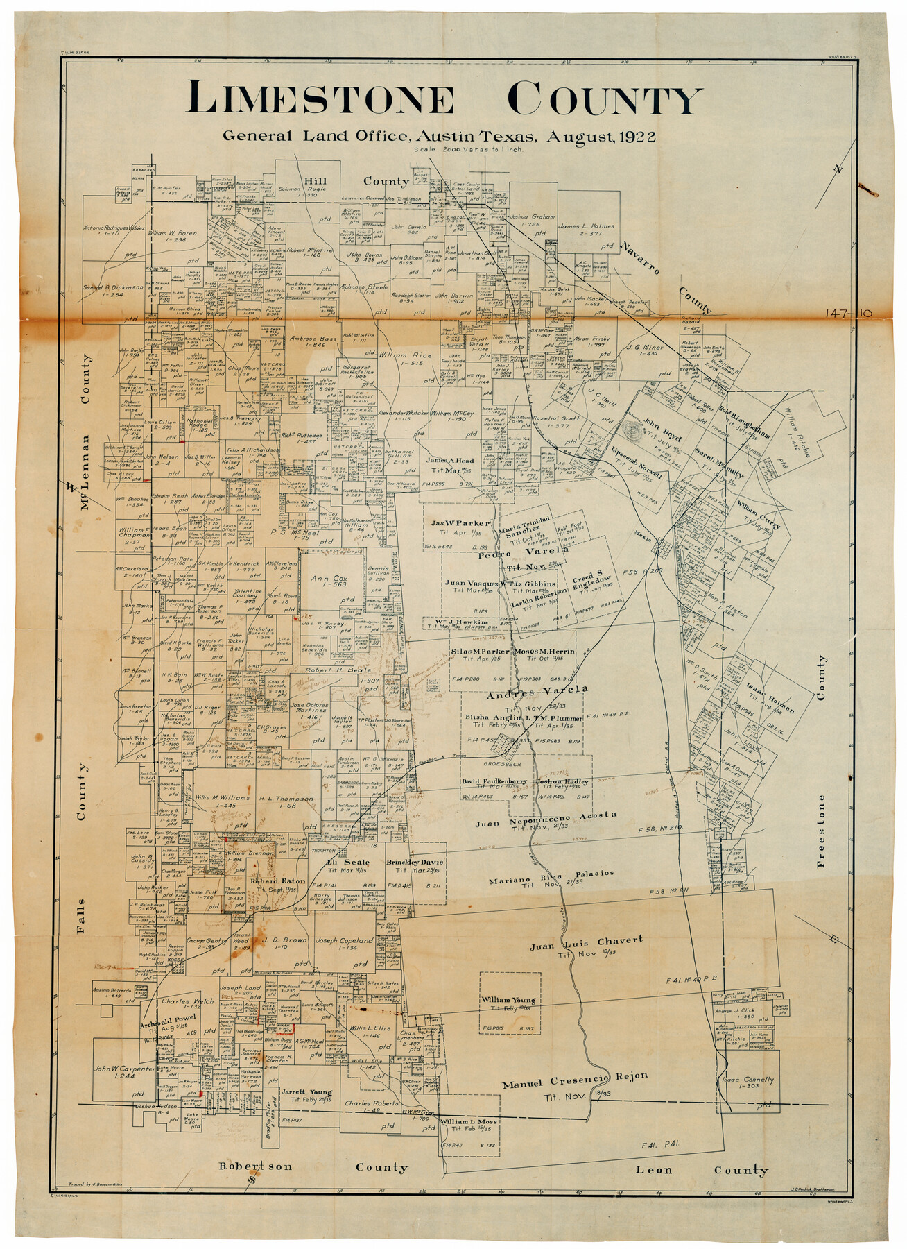
Limestone County, 1922
147-10
-
Map/Doc
89704
-
Collection
Twichell Survey Records
-
Object Dates
1922 (Creation Date)
-
People and Organizations
J.D. Hedick (Draftsman)
-
Counties
Limestone
-
Subjects
County
-
Height x Width
36.4 x 50.1 inches
92.5 x 127.3 cm
Part of: Twichell Survey Records
[Public School Land Leagues]
![90445, [Public School Land Leagues], Twichell Survey Records](https://historictexasmaps.com/wmedia_w700/maps/90445-1.tif.jpg)
Print $3.00
- Digital $50.00
[Public School Land Leagues]
Size 11.8 x 15.8 inches
Map/Doc 90445
[Blocks 44, 6T, 26, B10, and B12]
![91528, [Blocks 44, 6T, 26, B10, and B12], Twichell Survey Records](https://historictexasmaps.com/wmedia_w700/maps/91528-1.tif.jpg)
Print $20.00
- Digital $50.00
[Blocks 44, 6T, 26, B10, and B12]
Size 19.7 x 15.8 inches
Map/Doc 91528
[Townships 1 & 2, Blocks 53, 54 & 55]
![92952, [Townships 1 & 2, Blocks 53, 54 & 55], Twichell Survey Records](https://historictexasmaps.com/wmedia_w700/maps/92952-1.tif.jpg)
Print $20.00
- Digital $50.00
[Townships 1 & 2, Blocks 53, 54 & 55]
Size 34.3 x 20.0 inches
Map/Doc 92952
[Mrs. Adair Resurvey]
![89976, [Mrs. Adair Resurvey], Twichell Survey Records](https://historictexasmaps.com/wmedia_w700/maps/89976-1.tif.jpg)
Print $20.00
- Digital $50.00
[Mrs. Adair Resurvey]
1918
Size 36.5 x 27.4 inches
Map/Doc 89976
[Portions of Blocks T1, B, and T]
![90950, [Portions of Blocks T1, B, and T], Twichell Survey Records](https://historictexasmaps.com/wmedia_w700/maps/90950-1.tif.jpg)
Print $2.00
- Digital $50.00
[Portions of Blocks T1, B, and T]
1910
Size 13.8 x 4.3 inches
Map/Doc 90950
Map of Block "C" of J. E. and J. W. Rhea's Ranch situated in Parmer Co., Texas

Print $20.00
- Digital $50.00
Map of Block "C" of J. E. and J. W. Rhea's Ranch situated in Parmer Co., Texas
1905
Size 13.5 x 25.4 inches
Map/Doc 91600
[Sketch showing correct location of the North and East lines of the Nave McCord pasture fence]
![90896, [Sketch showing correct location of the North and East lines of the Nave McCord pasture fence], Twichell Survey Records](https://historictexasmaps.com/wmedia_w700/maps/90896-1.tif.jpg)
Print $20.00
- Digital $50.00
[Sketch showing correct location of the North and East lines of the Nave McCord pasture fence]
1900
Size 20.3 x 11.8 inches
Map/Doc 90896
![91464, [Block B7], Twichell Survey Records](https://historictexasmaps.com/wmedia_w700/maps/91464-1.tif.jpg)
[Sutton, Hale & Ector Co. School Land]
![90103, [Sutton, Hale & Ector Co. School Land], Twichell Survey Records](https://historictexasmaps.com/wmedia_w700/maps/90103-1.tif.jpg)
Print $3.00
- Digital $50.00
[Sutton, Hale & Ector Co. School Land]
Size 9.8 x 16.7 inches
Map/Doc 90103
[Sketch Showing Wm. T. Brewer, John R. Taylor, Wm. F. Butler, Timothy DeVore, L. M. Thorn and adjoining surveys]
![90230, [Sketch Showing Wm. T. Brewer, John R. Taylor, Wm. F. Butler, Timothy DeVore, L. M. Thorn and adjoining surveys], Twichell Survey Records](https://historictexasmaps.com/wmedia_w700/maps/90230-1.tif.jpg)
Print $20.00
- Digital $50.00
[Sketch Showing Wm. T. Brewer, John R. Taylor, Wm. F. Butler, Timothy DeVore, L. M. Thorn and adjoining surveys]
Size 25.1 x 19.2 inches
Map/Doc 90230
Cochran County, Texas

Print $40.00
- Digital $50.00
Cochran County, Texas
Size 38.1 x 48.3 inches
Map/Doc 89870
[River Secs. 68-73, Archer County School Land League 3 and surrounding surveys]
![90468, [River Secs. 68-73, Archer County School Land League 3 and surrounding surveys], Twichell Survey Records](https://historictexasmaps.com/wmedia_w700/maps/90468-1.tif.jpg)
Print $20.00
- Digital $50.00
[River Secs. 68-73, Archer County School Land League 3 and surrounding surveys]
Size 38.4 x 36.4 inches
Map/Doc 90468
You may also like

Stephens County Sketch File 17

Print $6.00
- Digital $50.00
Stephens County Sketch File 17
1912
Size 11.2 x 8.7 inches
Map/Doc 37074
Hill County Sketch File 8a

Print $4.00
- Digital $50.00
Hill County Sketch File 8a
1858
Size 10.2 x 8.1 inches
Map/Doc 26474
Flight Mission No. DAG-18K, Frame 68, Matagorda County

Print $20.00
- Digital $50.00
Flight Mission No. DAG-18K, Frame 68, Matagorda County
1952
Size 16.4 x 16.3 inches
Map/Doc 86361
Pecos County Rolled Sketch 111

Print $20.00
- Digital $50.00
Pecos County Rolled Sketch 111
1941
Size 30.0 x 20.9 inches
Map/Doc 7256
Dickens County Sketch File 22

Print $8.00
- Digital $50.00
Dickens County Sketch File 22
1913
Size 11.2 x 9.1 inches
Map/Doc 20985
Borden County Sketch File 1

Print $6.00
- Digital $50.00
Borden County Sketch File 1
Size 16.2 x 11.0 inches
Map/Doc 14701
Lubbock County Working Sketch 2

Print $20.00
- Digital $50.00
Lubbock County Working Sketch 2
Size 31.7 x 21.4 inches
Map/Doc 70661
In the Supreme Court of the United States, The State of Oklahoma, Complainant vs. The State of Texas, Defendant, The United States of America, Intervener, Red River Valley, Texas and Oklahoma Between the 98th and 100th Meridians in Five Sheets, 1921

Print $40.00
- Digital $50.00
In the Supreme Court of the United States, The State of Oklahoma, Complainant vs. The State of Texas, Defendant, The United States of America, Intervener, Red River Valley, Texas and Oklahoma Between the 98th and 100th Meridians in Five Sheets, 1921
1921
Size 38.4 x 60.0 inches
Map/Doc 75275
Real County Working Sketch 22

Print $20.00
- Digital $50.00
Real County Working Sketch 22
1945
Size 20.0 x 21.7 inches
Map/Doc 71914
Where Did Columbus Discover America?

Where Did Columbus Discover America?
1986
Size 14.7 x 20.6 inches
Map/Doc 96837
Shelby County Sketch File 4

Print $4.00
- Digital $50.00
Shelby County Sketch File 4
1852
Size 13.1 x 8.2 inches
Map/Doc 36597